Download
1 / 49
490 likes | 696 Vues
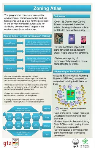
Antelope Valley Area Plan Update. Zoning Consistency Presentation. March 2012. Process Update. 1) Purpose of Presentation 2) Background 3) Land Use Policy 4) Zoning 5) Land Use Policy and Zoning 6) New Zones. Antelope Valley Area Plan Update. Purpose of Presentation.

E N D
Antelope Valley Area Plan Update Zoning ConsistencyPresentation March 2012
Process Update • 1) Purpose of Presentation • 2) Background • 3) Land Use Policy • 4) Zoning • 5) Land Use Policy and Zoning • 6) New Zones
Antelope Valley Area Plan Update Purpose of Presentation
Purpose of Presentation • What is zoning? • What is the difference between zoning and land use policy? Their relationship? • What zones are going to be used, both new and old? • Why is zoning on some properties are being changed? • How are the zones applied and matched to the land use policy?
Antelope Valley Area Plan Update Background
Background • Update of the 1986 Antelope Valley Area Plan • Population changes need to be accommodated • Account for environmental changes • Comply with State mandates
Background • Since project commencement in 2007: • 23 community meetings • Additional stakeholder meetings • March 2011: Release of Preliminary Draft Antelope Valley Area Plan • August 2011: Notice of Preparation • September 2011: EIR Scoping Meeting
Antelope Valley Area Plan Update Land Use Policy
Land Use Policy • Rural Preservation Strategy • Maintain rural lifestyle • Environment and biology protection • Open space preservation • Continued agricultural uses • Conservation of non-renewable resources • Increased mobility options
Land Use Policy • How the Land Use Policy was applied • Workshop participants helped to define general areas • Land use designations within existing communities include “higher” densities, ranging from RL5 on the low end to H30 on the high end • Less developed areas are based on the Hazards and Environmental Constraints Map where the lowest densities are applied, ranging from RL40 on the low end to RL10 on the high end
Land Use Policy • How the Land Use Policy was applied • Hazards and Environmental Constraints Map Class I = 1du/10ac Class II = 1du/20ac Class III = 1du/40ac
Land Use Policy • How the Land Use Policy was applied
Land Use Policy and Zoning • Connection between Land Use Policy and Zoning • Land Use Policy provides the overall framework and general direction for development of a parcel • Zoning implements Land Use Policy by detailing the specific development standards for individual parcels • Zoning has to be consistent with the Land Use Policy
Zoning • Determines the permitted uses on a parcel • Spells out specific development standards regulating the use of individual parcels (i.e. setbacks, max heights, min lot sizes etc.) • Has the force of law; provisions are enforced by the County • Ensures that the exercise of an individual owner’s property rights does not encroach upon the rights of another property owner
Zoning - Current • R-1: Single-family Residence Zone • R-2: Two-family Residence Zone • R-3: Limited Multiple Residence Zone • R-A: Residential Agricultural Zone • A-1: Light Agriculture Zone • A-2: Heavy Agriculture Zone • C-1: Restricted Business Zone • C-2: Neighborhood Business Zone • C-3: Unlimited Commercial Zone • M-1: Light Manufacturing Zone • M-2: Heavy Manufacturing Zone • D-2: Desert-Mountain Zone • R-R: Resort-Recreation Zone *This is not an inclusive listing of all zones.
Zoning - New • R-1: Single-family Residence Zone • R-2: Two-family Residence Zone • R-3: Limited Multiple Residence Zone • R-A: Residential Agricultural Zone • A-1: Light Agriculture • A-2: Heavy Agriculture • C-RU: Rural Commercial • MXD –RU: Rural Mixed Use • M-1: Light Manufacturing Zone • M-2: Heavy Manufacturing Zone • C-R: Commercial Recreation Zone • (no C-1, C-2, C-3, D-2 and R-R zones in the AV) *This is not an inclusive listing of all zones.
Antelope Valley Area Plan Update Land Use Policy and Zoning
Land Use Policy and Zoning Commercial & Industrial
Land Use Policy and Zoning Residential
Land Use Policy and Zoning Agricultural
Possible Uses Agricultural and Residential
Land Use Policy and Zoning Density vs Minimum Lot Size • Density (Land Use Policy) • Determines the number of dwelling units allowed in a given parcel (i.e. RL10 allows 2 units in 20 ac, 4 units in 40 ac, 6 units in 60 ac etc.) • determines the number of parcels a property can be subdivided into • Minimum Lot Size (Zoning) • determines the smallest size any one of the resulting parcels can be (i.e. A-2-10,000 = 10,000 sq ft; A-2-2 = 2 acres)
Land Use Policy and Zoning Density vs Minimum Lot Size Sample Scenario: 40 ac lot, RL10, A-2-2 * RL10 will allow 4 units in 40 acres * A-2-2 will allow newly subdivided lots as small as 2 acres 10 ac 10 ac 34 ac 2 ac 2 ac 2 ac 10 ac 10 ac
Land Use Policy and Zoning Density vs Minimum Lot Size
Antelope Valley Area Plan Update New Zones
Rural Zones Rural Commercial (C-RU) • Most Town Centers and other Commercial areas • Parking provisions for large vehicles such as dually trucks and utility vehicles • In Special Parking Districts: parking provisions for RVs, vehicle with trailers and semi-trucks. • Additional requirements for parcels adjacent to Residential and Agricultural zones
Possible Uses in C-RU • Permitted Uses • Restaurants • Stores (including auto and RV Sales) • Professional Offices • Automobile battery service/brake repair/muffler shops • Uses requiring a CUP • Automobile body/fender repair, painting and upholstering
Rural Zones Rural Mixed Use (MXD-RU) • Town Centers of Littlerock, Quartz Hill and Lake Los Angeles • Same parking provisions and development standards as C-RU • Allows Mixed Use Development (Residential and Commercial uses on the same parcel) • Apartments (up to 5 units) • Duplexes • Townhouses
Mixed Use Development in MXD-RU Vertical Horizontal Commercial Residential Residential Commercial
Possible Uses in MXD-RU • Permitted Uses • Restaurants • Stores • Professional Offices • Auto sales (No RV Sales) • Uses requiring a CUP • Automobile battery service/brake repair/muffler shops (No body/fender repair, painting, upholstery)
Prohibited Uses in a Mixed Use Development • Prohibited in Mixed Use Development • Automobile repair • Utility buildings • Hospitals • Meat markets • Menageries/Zoos • Mortuaries • Veterinary clinics
Optional Rural Parking C-RU and MXD-RU Standard Large Vehicles RV/Trailer (in certain areas) * Images taken from: www.netcarshow.com, www.hybridcars.com, www.rvstoredirect.com, www.happytrailstrailers.com
Optional Rural Parking Provisions – Semi-trucks • Only in certain areas • Subject to restrictions * Source: www.featurepics.com
Antelope Valley Area Plan Update GIS Maps
Sample GIS-NET Maps Land Use Policy RL10 RL10 RL1 H2 CR-MU RL10 RL20 RL5 H2
Sample GIS-NET Maps Zoning
For More Information Visit the TOWN & COUNTRY website: http://planning.lacounty.gov/tnc
For More Information Land Use Policy and Zoning Map: http://planning.lacounty.gov/gisnet
For More Information Call us: (213) 974-6476 E-mail us: tnc@planning.lacounty.gov Write us: Department of Regional Planning Community Studies North 320 W Temple Street Los Angeles, CA 90012 http://planning.lacounty.gov/tnc
For More Information Special Office Hours: 9:00am-12:00pm & 1:00-3:00pm at County Field - Monday, April 9 Office in Lancaster - Tuesday, April 17 (335A E Ave K-6) - Monday, April 23 - Thursday, May 3 - Thursday, May 10 - Wednesday, May 16 - Thursday, May 31 Appointments recommended. Otherwise, first come first served.