Download
1 / 36
360 likes | 367 Vues
Satellites and NWS Aviation Activities Mark Andrews NWS Headquarters OCWWS/Meteorological Services Div. Aviation Weather Services Branch Frederick R. Mosher NWS/NCEP/Aviation Weather Center. GOES Satellite Data. GOES data continually used in aviation forecast operations.

E N D
Satellites and NWS Aviation ActivitiesMark AndrewsNWS HeadquartersOCWWS/Meteorological Services Div. Aviation Weather Services BranchFrederick R. MosherNWS/NCEP/Aviation Weather Center
GOES Satellite Data • GOES data continually used in aviation forecast operations. • AWC has a direct readout facility. • GOES data is used in conjunction with other observations and forecast data. • Local imaging processing of GOES digital data adds to its value
Aviation is Weather Sensitive • Thunderstorms • Turbulence • Aircraft Icing • Volcanic Ash • Head/Tail Winds • Clouds/Restricted Visibility
Thunderstorms • GOES data used to integrate and make sense of other observations.
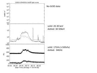
Lightning Data +GOES IR Bad lightning data Elongated data
Thunderstorms • GOES data used to integrate and make sense of other observations. • Pattern recognition of anvil patterns.
Thunderstorms • GOES data used to integrate and make sense of other observations. • Pattern recognition of anvil patterns. • Derived thunderstorm products such as Global Convective Diagnostic (GCD).
Global Convective Diagnostic (GCD) • New GCD method makes use of temperature difference between the infrared and water vapor channels. These channels are available on all geostationary satellites. • GCD processed at AWC from Direct Readout digital data.
GCD ThunderstormDetection Tir=Twv Tir>Twv
Global Convective Product (GCD) now available on AWC web page http://aviationweather.gov/gcd/
Turbulence • Overlay of Pilot reports on Water Vapor • Pattern Recognition: Jet cores, transverse banding of clouds, water vapor image darkening, location of troughs and ridges, etc. See Gary Ellrod’s papers for details.
Water Vapor Image with Overlaid Pilot Reports and Ellrod Index Moderate turbulence Ellrod Index Jet core
Aircraft Icing • In flight icing caused by by supercooled water droplets within clouds. Remote detection is still not solved problem. • Current Icing Potential (CIP) product uses GOES cloud information to edit model relative humidity and temperature information.
Volcanic Ash Detection • GOES satellite images main tool for detection and tracking of ash. • Multiple channels are used to detect the ash depending on the situation. • Visible Channel • 11-12 micron difference. • 3.9, 11, 13, visible multispectral products.
Winds Affect Flight Times and Fuel Consumption • Flight Planning requires accurate knowledge of winds at flight levels. • Winds obtained from radiosondes, aircraft, temperature soundings, and feature tracked winds from satellite images. • Infrared, visible, and water vapor images used for feature tracked winds.
Clouds/Restricted Visibility • Flying into the ground/mountains is the most frequent weather related fatality for general aviation pilots. • Night time Fog image (3.9-11 micron) has been a major improvement in monitoring fog and low cloud situations.
Fog image at night with surface IFR/VFR observations overlay
Summary • GOES satellite data is widely used in detection of aviation weather hazards. • Direct readout facilities allow for local image processing of products for local use. • Additional information/programs for aviation related image processing available from Frederick.R.Mosher@noaa.gov