Download
1 / 7
70 likes | 159 Vues
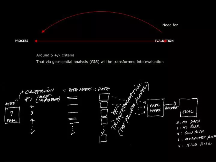
Need for. PROCESS EVALUATION. Around 5 +/- criteria That via geo-spatial analysis (GIS) will be transformed into evaluation. CRITERIA FOR DATA NEEDS. WHAT is important? (Slope)

E N D
Need for PROCESS EVALUATION Around 5 +/- criteria That via geo-spatial analysis (GIS) will be transformed into evaluation
CRITERIA FOR DATA NEEDS • WHAT is important? (Slope) • Why is it important? • because of vulnerability model (ex. AEC) • because of attractiveness model • HOW is It important? (“bad or good) • How does it influence evaluation? • HOW important is it? “building constrain” • Determinates use
Evaluation Value Range CRITERIA DATA NEED? Spatial Operations GIS Evaluations Map Vulnerability Map Map 1…. 2… MAP MAP 1…. 2… MAP FINAL MAP housing allocations MAP 1…. 2… MAP 1…. 2… MAP MAP 1…. 2… MAP
Examples of criteria carried develop in flow diagram Evaluation Value Range FUNDAMENTALS CRITERIA DATA NEED? Spatial Operations Evaluation Map EVALUATION MAP Preservation of remainder of the past are necessary to maintain a sense of place PROXIMITY to heritage sites is important to maintain sense of place 1.Euclidian Distance 2.Reclassify Historic Sites Roads