Download
1 / 22
220 likes | 315 Vues
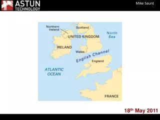
River Monitoring and Climate Change Conference Leominster, MA May 18, 2011 Sponsored by. Understanding Habitat Vulnerability Under Climate Change Conditions John O ’ Leary Massachusetts Division of Fisheries and Wildlife.

E N D
River Monitoring and Climate Change Conference Leominster, MAMay 18, 2011Sponsored by
Understanding Habitat Vulnerability Under Climate Change ConditionsJohn O’Leary Massachusetts Division of Fisheries and Wildlife
Understanding the factors that make your watershed vulnerable to climate change conditions is an important first step to developing a monitoring strategy
Project Goal To ensure that the wildlife conservation strategies detailed in the State Wildlife Action Plan (SWAP) are adapted for climate change impacts
Vulnerability • The IPCC definition of vulnerability: “depends not only on a system’s sensitivity, but also on its ability to adapt to new climate conditions” (Watson et al. 1966: 23)
Climate Change Information used in Vulnerability Assessment • Results from Northeast Climate Impacts Assessment Report (Hayhoe 2006) • High and low carbon dioxide emissions scenarios • Provided information on future climate conditions: temperature; type , amount and timing of precipitation; extreme events
Sensitivity and Adaptive Capacity Variables 1. Current rate of loss 2. Elevation 3. Latitude 4. Vulnerability to increasing temperature 5. Vulnerability to increased attack by biological stressors (grazers and browsers, pests, invasives, pathogens) 6. Habitat intrinsic dispersive rate 7. Vulnerability to increased frequency or intensity of extreme events (fire, drought, windstorms, floods) 8. Vulnerability to phenologic change 9. Vulnerability to human maladaptive responses 10. Vulnerability due to obstacles to range shifts 11. Likely future impacts of non-climate stressors
HABITAT VULNERABILITY CATEGORIES 7 High risk of being eliminated entirely from state 6 Majority of habitat may be eliminated (>50%) but not entirely 5 Risk of substantial reduction in habitat area (<50% loss) 4 Extent of habitat may not change appreciably 3 Habitat may become established in state 2 Extent of habitat may expand moderately (<50%) 1 May greatly benefit from climate change (>50% range extension)
Habitat Types Evaluated • Spruce-Fir Forest • Northern Hardwood Forest • Southern/Central Hardwood Forest • Pitch pine-scrub oak Community • Coldwater Rivers and Streams • Large Coldwater Lakes • Smaller Coldwater Lakes and Ponds • Warmwater Ponds, Lakes, and Rivers • Coldwater Kettle Ponds • Connecticut and Merrimack Mainstems • Emergent Marsh • Shrub Swamp • Spruce-fir Boreal Swamp • Atlantic White Cedar Swamp • Riparian Forest • Hardwood Swamp • Vernal Pools • Intertidal Mud/Sandflats • Saltmarsh • Brackish Marsh
Vulnerability and confidence scores (in parentheses) • Habitat Low Emissions High Emissions • Forested Habitats • Spruce-fir Forest 6 (High) 7 (High) • Northern Hardwood Forest 5 (Medium) 6 (Medium) • Central/Southern Hardwood • Forest 1 (Medium) 1 (Medium) • Pitch pine-scrub oak • Community 4 (Medium) 4 (Medium) • Freshwater Aquatic Habitats • Coldwater Rivers/Streams 5 (High) 6 (High) • Large Coldwater Lakes 5 (Medium) 6 (Medium) • Smaller Coldwater Lakes and • Ponds 7 (High) 7 (High) • Coldwater Kettle Ponds 5 (Low) 5 (Low) • Warmwater Ponds, Lakes, and • Rivers 2 (Medium) 2 (Medium) • Connecticut and Merrimack • Mainstems 5 (Medium) 6 (Medium) Habitat Low Emissions High Emissions Wetland Habitats Emergent Marsh 5 (High) 6 (High) Shrub Swamp 4/5 (Medium) 2 (Medium) Spruce-fir Boreal Swamp 6 (High) 7 (High) Atlantic White Cedar Swamp 4 (Medium) 5 (Medium) Riparian Forest 5 (Low) 5 (Low) Hardwood Swamp 4 (Medium) 5 (Medium) Vernal Pools 4 (Low) 5 (Low) Coastal Habitats Intertidal Mud/Sandflats 6 (High) 6 (High) Saltmarsh 1 (High) 1 (High) Brackish Marsh 6 (High) 6 (High)
Four Key Elements for Watershed Vulnerability Assessment • Projected changes in precipitation • Projected changes in temperature • Existing impacts • Potential maladaptive responses by society
Climate Change ProjectionsTemperature • By mid-century, mean annual temperature is projected to increase 3.7°-5.8°F • End-of-century projections suggest a greater mean annual temperature increase in the western part of the state. • Mean winter temperatures are projected to increase 4.3°-6.1°F (mid-century) and 5.8°-9.8°F (end-of-century) • Mean summer temperatures are projected to increase 3.8°-6.4°F (mid-century) and 5.1°-10.6°F (end-of-century)
Climate Change ProjectionsPrecipitation • By mid-century, projections indicate an increase of approximately 100 mm in total annual precipitation for the state. • Eastern regions of the state may receive 25-50mm more in total annual precipitation than western regions of the state. • Mean snow depth in the state will be 13-20 cm less than the reference period (1971-2000)
Existing Impacts • Amount of impervious surface • Fragmentation • Water withdrawals • Channel modifications • Riparian corridor
Maladaptive Responsesto Climate Change Impacts • Dikes and Levees • Chemical weed control in lakes • Broad scale spaying of wetlands to control disease vectors • New dam construction for flood control or to augment flow during low flow periods
Connecticut River Example • Projected changes in precipitation - Snow pack driven hydrograph • Projected changes in temperature - Ponding of water behind dams, lack of riparian cover • Existing impacts – Dams, storm-water runoff, impervious surfaces, connection to flood plain • Potential maladaptive responses by society - More Dams? More Dikes? Channelization? More, More, More….
Changes in Precipitation Timing, Amount and Type will Impact Habitats
For more Information • To find the Vulnerability Assessment Reports go to www.mass.gov/dfwele/dfw/click on Habitat, go to the State Comprehensive Wildlife Strategy and click on Climate Change in the quick links box • For Climate Project information go to www.climatewizard.org