Download
1 / 18
180 likes | 340 Vues
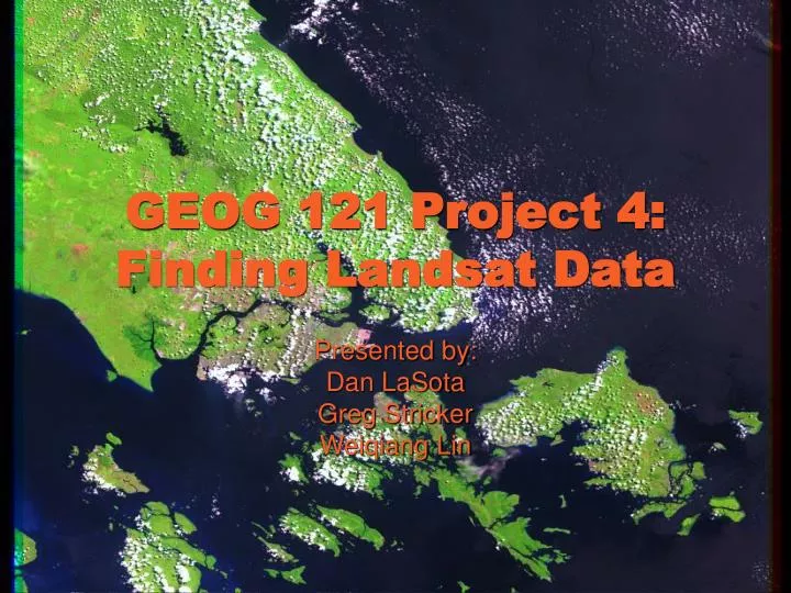
GEOG 121 Project 4: Finding Landsat Data. Presented by: Dan LaSota Greg Stricker Weiqiang Lin. About Landsat: Purpose. The Landsat Program is established to acquire remote sensing imagery of the earth for monitoring and managing the Earth's resources.

E N D
GEOG 121 Project 4:Finding Landsat Data Presented by: Dan LaSota Greg Stricker Weiqiang Lin
About Landsat: Purpose • The Landsat Program is established to acquire remote sensing imagery of the earth for monitoring and managing the Earth's resources. • Applications include: agriculture, geology, forestry, regional planning, education, national security and global climate change research. • Landsat 7 is the most recent NASA satellite among 6 others that have produced a continuous multispectral record of the Earth's land surface for 32 years now. • Special Emphasis on: Currency, accuracy, affordability and public accessibility of Landsat Data. • It is used across disciplines to achieve improved understanding of the Earth's land surfaces and the impact of humans on the environment.
About Landsat: Brief History • NASA initiated an Earth Resources Survey (ERS) Program 1965 to develop methods for remote sensing of earth resources from space. • First Earth Resources Technology Satellite (Landsat 1) launched in 1972 with two Earth-viewing sensing systems • a return beam vidicon (RBV) – discontinued after Landsat 3 and • an 80 meter multispectral scanner (MSS). • Original MSS measures radiation within four narrow bands that span visible green wavelengths, visible red wavelengths, and slightly longer, near-IR wavelengths. • Landsat 4 launched in 1984 with the MSS and the Thematic Mapper (TM) featuring higher spatial resolution (30 meters) and improved spectral sensitivity (7 bands, including visible blue, two mid-infrared, & thermal infrared wavelengths). • The Landsat 7 Enhanced Thematic Mapper Plus (ETM+) Sensor was launched in Apr 1999, with improved resolution and precision, necessitated by the high costs of imaging, Land Remote Sensing Policy Act (1992) and the loss of Landsat 6. • Landsat is a tri-agency joint program of NASA, NOAA and the USGS.
About Landsat: Satellite Characteristics Source: http://ltpwww.gsfc.nasa.gov/IAS/handbook/handbook_htmls/chapter1/chapter1.html#section1.1
About Landsat: How it works? Space Segment • The ETM+ sensor onboard the spacecraft obtains data along the ground track at a fixed swath (185 km in width). • The orbit of Landsat 7 is repetitive, circular and near polar at a nominal altitude of 705 km (438 miles) at the Equator. • The spacecraft completes just over 14 orbits per day, covering the entire Earth between 81 degrees N & S latitude every 16 days. • A multispectral data set having high (30 meter) & medium to coarse (250 to 1000 meter) spatial resolution is acquired on a global basis repetitively. Source: http://ltpwww.gsfc.nasa.gov/IAS/handbook/handbook_htmls/chapter5/htmls/swath_pattern.html
About Landsat: How it works? Ground Segment • Segment consists of both Landsat 7 unique components as well as institutional services. Some examples: • Landsat 7 Unique Components • Landsat Ground Station LGS, located at EDC, in Sioux Falls, SD is a receive site for the wideband X-Band downlinksof payload data from the space vehicle. • In addition to LGS, the Alaska Ground Station & the Svalbard Norway Ground Station receive payload data downlinks. • International Ground Stations are satellite data receiving stations located worldwide. They receive, process, & distribute services. • Institutional Services • Landsat Ground Networkprovides communication support. • Space Network – relay services • NASA Integrated Support Network – supports Institutional Services
About Landsat: Products • Level 0R Product: an essentially raw data form that is marginally useful prior to radiometric and geometric correction. • Level 1R product is a radiometrically corrected 0R product. 1R product & 0R at input level have identical geometry. • The 1G product is available to users and is a radiometrically and systematically corrected 0R image. • Can be processed by LPGS or NLAPS • Geometrically rectified for sensor/satellite/terrestrial distortions • Scene rotated, aligned, & georeferenced to a user-defined map projection. • Earthexplorer always utilize the low gain LMAX value when scaling the radiance of a scene so that all pixels saturate at the same radiance. • Others: 1P (precision corrected), 1T (terrain corrected), SLC-off Products
About Landsat: Distribution • Landsat 7 data distribution system will provide access to Landsat 7 Level 0R data products within 24 hours of collection, and • Level 1 processed products within 48 hours of request. • Media: • Exabyte tape • CD-ROM or • Electronic transfer via FTP • Imagery of foreign land masses will be recorded to EDC at Sioux Falls, yet the temporal depth will be a fraction of what's available at the international ground stations.
What is SLC-off? • An instrument malfunction occurred onboard Landsat 7 on May 31, 2003. The problem was caused by failure of the Scan Line Corrector (SLC), which compensates for the forward motion of the satellite. • The center of a SLC-off data product is very similar in quality to previous Landsat 7 data. However, the scene's edges will contain alternating scan lines of missing data or duplicated data. • As of 5/10/2004, product is in 1G form and has the gap areas filled with Landsat 7 data acquired at a similar time of year prior to the failure. • EDC has reduced the price of Landsat 7 ETM+ SLC-off scenes from $600 to $250.
How to do Project 4 Generating Landsat Image To find coordinates: www.census.gov/cgi-bin/gazetteer To generate Landsat Image: http://earthexplorer.usgs.gov Click on “Enter as: Guest” Click on “Enter Coordinates” to do so in Decimals/DDMMSS Under Data Set Selection, check the box for “ETM+ SLC-off (Landsat 7, Jul 2003 – Present) Click “Continue”, then “Search” on the following page When the search is completed, click on the Data Set “ETM+ SLC-off (Landsat 7, July 2003 - present)”
How to do Project 4 Creating the Report • Click on the “Show” button, under the column “Preview Image”, that corresponds to the smallest amount of cloud cover and the most recent image. • Right click to Save Picture As (e.g. jpg) for Project 4. • Click on the “Show” button under “Show All Fields” for your image to show metadata. • Hyperlink the metadata to Project 4 - OR • Click on File and choose “Properties” • Copy the URL for the metadata • Create new page for metadata using Microsoft Frontpage • Upload it to Pass Explorer • Provide a link in Project 4 to this Metadata Page.
How to do Project 4 Answering the Questions • Note Scene Acquisition Date for the image you have selected. • The World Reference System (WRS) indexes orbits (paths) and scene centers (rows) into a global grid system, comprising 233 paths by 248 rows. • The standard WRS scene as defined for Landsats 4 and 5 was preserved as a product for Landsat 7. • A path distance of 90 kilometers before and after a WRS center point defines the standard scene length of 180 km (includes 20 scans of overlap) The standard WRS scene overlaps neighboring scenes along a path by 5% at the equator and has a width or cross track distance of 185 kilometers. • Definitions • The term row refers to the latitudinal center line across a frame of imagery along any given path. • The intersection of rows and paths produces the nominal scene center for that landsat image • The path/row numbers do not coincide with latitudes 90° north and south.
How to do Project 4 Answering the Questions • Location and Extent of the Scene • Coordinates of the NW, NE, SW and SE corners can be found in the metadata • Cost of actual Landsat scene that corresponds to the free browse image: • USGS Landsat ETM+ : $600.00 for first scene • USGS Landsat ETM+ SLC-Off : $250.00 for first scene • http://edcsns17.cr.usgs.gov/helpdocs/prices.html#LANDSAT_ETM+
Sources • NASA Landsat Program (2004) http://geo.arc.nasa.gov/sge/landsat/landsat.html • Landsat 7 Science Data Users Handbook (2004) http://ltpwww.gsfc.nasa.gov/IAS/handbook/handbook_toc.html • U.S. Census Bureau (2000) www.census.gov/cgi-bin/gazetteer • USGS Earthexplorer (2004) http://earthexplorer.usgs.gov • USGS Landsat Project (2004) http://landsat.usgs.gov/programdesc.html • Esri Online Campus (2004) http://campus.esri.com