Download
1 / 1
10 likes | 194 Vues
Sergio F. Abarca 1 , Luis M. Farfán 2 , Julio C. Marín 3 and Graciela B. Raga 4. 1 Naval Postgraduate School, 2 Centro de Investigaci ón Científica y Educaci ón Superior de Ensenada, 3 Universidad de Valparaíso, 4 Universidad Nacional Aut ó noma de M éxico. Background.

E N D
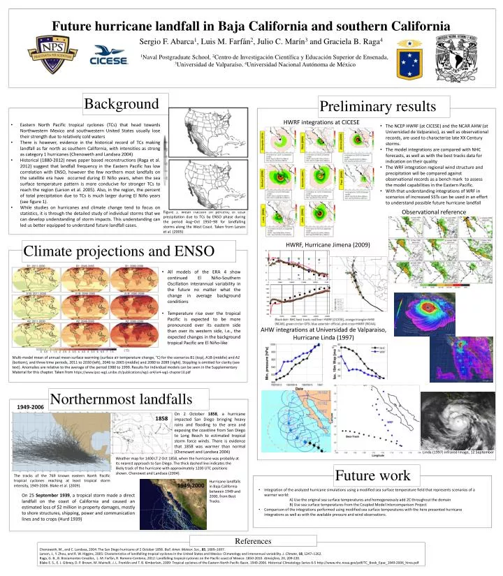
Sergio F. Abarca1, Luis M. Farfán2, Julio C. Marín3 and Graciela B. Raga4 1Naval Postgraduate School, 2Centro de InvestigaciónCientífica y Educación Superior de Ensenada, 3Universidad de Valparaíso, 4Universidad NacionalAutónoma de México Background Preliminary results HWRF integrations at CICESE • Eastern North Pacific tropical cyclones (TCs) that head towards Northwestern Mexico and southwestern United States usually lose their strength due to relatively cold waters • There is however, evidence in the historical record of TCs making landfall as far north as southern California, with intensities as strong as category 1 hurricanes (Chenoweth and Landsea 2004) • Historical (1880-2012) news paper based reconstructions (Raga et al. 2012) suggest that landfall frequency in the Eastern Pacific has low correlation with ENSO, however the few northern most landfalls on the satellite era have occurred during El Niño years, when the sea surface temperature pattern is more conducive for stronger TCs to reach the region (Larson et al. 2005). Also, in the region, the percent of total precipitation due to TCs is much larger during El Niño years (see figure 1). • While studies on hurricanes and climate change tend to focus on statistics, it is through the detailed study of individual storms that we can develop understanding of storm impacts. This understanding can led us better equipped to understand future landfall cases. • The NCEP HWRF (at CICESE) and the NCAR AHW (at Universidad de Valparaiso), as well as observational records, are used to characterize late XX Century storms. • The model integrations are compared with NHC forecasts, as well as with the best tracks data for indication on their quality • The WRF integration regional wind structure and precipitation will be compared against observational records as a bench mark to assess the model capabilities in the Eastern Pacific. • With that understanding integrations of WRF in scenarios of increased SSTs can be used in an effort to understand possible future hurricane landfall Future hurricane landfall in Baja California and southern California Observational reference HWRF, Hurricane Jimena (2009) Climate projections and ENSO • All models of the ERA 4 show continued El Niño-Southern Oscillation interannual variability in the future no matter what the change in average background conditions • Temperature rise over the tropical Pacific is expected to be more pronounced over its eastern side than over its western side, i.e., the expected changes in the background tropical Pacific are El Niño-like AHW integrations at Universidad de Valparaiso, Hurricane Linda (1997) Multi-model mean of annual mean surface warming (surface air temperature change, °C) for the scenarios B1 (top), A1B (middle) and A2 (bottom), and three time periods, 2011 to 2030 (left), 2046 to 2065 (middle) and 2080 to 2099 (right). Stippling is omitted for clarity (see text). Anomalies are relative to the average of the period 1980 to 1999. Results for individual models can be seen in the Supplementary Material for this chapter. Taken from https://www.ipcc-wg1.unibe.ch/publications/wg1-ar4/ar4-wg1-chapter10.pdf Northernmost landfalls Hurricane Linda (1997) Figure 1. Mean fraction (in percent) of total precipitation due to TCs by ENSO phase during the period Aug–Oct 1950–98 for landfalling storms along the West Coast. Taken from Larson et al. (2005) 1949-2006 On 2 October 1858, a hurricane impacted San Diego bringing heavy rains and flooding to the area and exposing the coastline from San Diego to Long Beach to estimated tropical storm force winds.There is evidence that 1858 was warmer than normal (Chenowet and Landsea 2004) 1858 Linda (1997) infrared Image, 12 September Weather map for 1400 LT 2 Oct 1858, when the hurricane was probably at its nearest approach to San Diego. The thick dashed line indicates the likely track of the hurricane with approximately 1200 UTC positions shown. Chenowet and Landsea (2004). Future work The tracks of the 769 known eastern North Pacific tropical cyclones reaching at least tropical storm intensity, 1949-2006. Blake et al. (2009). 1949-2000 Hurricane landfalls in Baja California between 1949 and 2000, from Best Tracks. • Integration of the analyzed hurricane simulations using a modified sea surface temperature field that represents scenarios of a warmer world: • A) Use the original sea surface temperatures and homogeneously add 2C throughout the domain • B) Use sea surface temperatures from the Coupled Model IntercomparisonProject • Comparison of the integrations performed using modified sea surface temperatures with the here presented hurricane integrations as well as with the available pressure and wind observations. On 25 September 1939, a tropical storm made a direct landfall on the coast of California and caused an estimated loss of $2 million in property damages, mostly to shore structures, shipping, power and communication lines and to crops (Hurd 1939) References Chenoweth, M., and C. Landsea, 2004: The San Diego hurricane of 2 October 1858. Bull. Amer. Meteor. Soc., 85, 1689–1697. Larson, J., Y. Zhou, and R. W. Higgins, 2005: Characteristics of landfalling tropical cyclones in the United States and Mexico: Climatology and interannual variability. J. Climate, 18, 1247–1262. Raga, G. B., B. Bracamontes-Cevallos, L. M. Farfán, R. Romero-Centeno, 2012: Landfalling tropical cyclones on the Pacific coast of Mexico: 1850-2010. Atmósfera, 20, 209-220. Blake E. S., E. J. Gibney, D. P. Brown, M. Mainelli, J. L. Franklin and T. B. Kimberlain, 2009: Tropical cyclones of the Eastern North Pacific Basin, 1949-2006. Historical Climatology Series 6-5 http://www.nhc.noaa.gov/pdf/TC_Book_Epac_1949-2006_hires.pdf