Download
1 / 13
130 likes | 219 Vues
O ver-storm GH for inner-core convection/RI/mature. Science Questions What is role of hot towers in TC intensification and RI? Are they a cause of intensification or an effect?

E N D
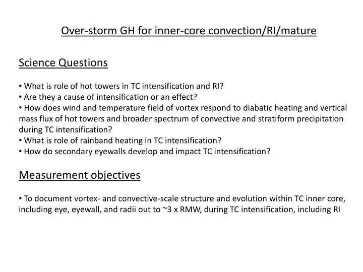
Over-storm GH for inner-core convection/RI/mature • Science Questions • What is role of hot towers in TC intensification and RI? • Are they a cause of intensification or an effect? • How does wind and temperature field of vortex respond to diabatic heating and vertical mass flux of hot towers and broader spectrum of convective and stratiform precipitation during TC intensification? • What is role of rainband heating in TC intensification? • How do secondary eyewalls develop and impact TC intensification? • Measurement objectives • To document vortex- and convective-scale structure and evolution within TC inner core, including eye, eyewall, and radii out to ~3 x RMW, during TC intensification, including RI
Basic patterns for over-storm GH for inner-core convection/RI/mature • Vortex survey patterns (fig-4, butterfly, rotating fig-4) • Purpose • - to provide spatial coverage of vortex structure via radial legs • Conditions for flying • If there is a TC with a reasonable chance of intensifying over next 48 h; “reasonable” being defined by best available guidance (e.g., SHIPS, SHIPS Rapid Intensification Index, numerical model guidance) • No flight/cancellation if TC expected to enter obviously hostile environment over next 48 h (e.g., landfall, extremely high vertical shear, very cold SST’s) • Guidelines • - basic pattern on which modules are attached • - repeat pattern for temporal evolution • Descope/contingency • - fly box pattern around eyewall if too turbulent to overfly eyewall • - number of azimuths (i.e., fig-4, butterfly, rotating fig-4) and leg • lengths can be adjusted to reduce on-station time
Figure-4 IP 4 3 2 Flight time 100 km leg: 0.96 h 200 km leg: 1.82 h (100 km leg shown here) Purpose: Vortex survey
Butterfly 6 IP 4 3 2 5 Flight time 100 km leg: 1.46 h 200 km leg: 2.72 h (100 km leg shown here) Purpose: Vortex survey
Rotating Figure-4 IP 7 4 8 6 3 5 2 Purpose: Vortex survey Flight time 100 km leg: 1.88 h 200 km leg: 3.51 h (100 km leg shown here)
Basic patterns for over-storm GH for inner-core convection/RI/mature • Modules (Bowtie, racetrack, or lawnmower) • Purpose • - to sample convective burst, or if system is highly-sheared storm • - provide high-temporal resolution sampling to monitor convective • structure and evolution • Conditions for flying • If, during the execution of a vortex survey pattern, satellite data or radar data from NOAA P-3 indicates a convective burst is occurring within inner core and within reasonable distance of GH • If TC is experiencing asymmetric distribution of precipitation, e.g., in response to vertical shear • Guidelines • - repeat pattern for temporal evolution as many times as possible without significantly degrading vortex survey (e.g., should be completed in < 2 h time) • Descope/contingency • - size of pattern can be modified to reduce module time
Convective burst or sheared/asymmetric precipitation module Bowtie (green) and racetrack (red) Note: axis of pattern for module can be rotated; leading convective/trailing stratiform schematic shown here not likely to be seen in eyewall of mature TC
Example: Hurricane Bonnie (1998) Sheared TC with convective burst on NE side IP 4 7 5 6 8 3 2 Purpose: Vortex survey pattern
Example: Hurricane Bonnie (1998) Sheared TC with convective burst on NE side: Upon completion of survey pattern, execute burst module, then repeat survey 12 9 11 10 8 Purpose: Convective burst or sheared/asymmetric precipitation Option 1: racetrack pattern
Example: Hurricane Bonnie (1998) Sheared TC with convective burst on NE side: Upon completion of survey pattern, execute burst module, then repeat survey 13 12 9 14 11 10 8 Purpose: Convective burst or sheared/asymmetric precipitation Option 2: lawnmower pattern
Basic patterns for over-storm GH for inner-core convection/RI/mature • Modules (outside primary eyewall, e.g., concentric eyewall, rainband modules) • Purpose • - to provide greater azimuthal coverage of concentric eyewalls, rainbands • Conditions for flying • If, during the execution of a vortex survey pattern, satellite data or radar data from NOAA P-3 indicates a concentric eyewall or principal rainband is present • Guidelines • - box pattern can be flown for concentric eyewall module, racetrack-type pattern for temporal evolution for rainband module • Descope/contingency • - size of pattern, e.g., length of racetrack legs, can be modified to reduce module time
Box (red) Box (red) and racetrack (black) Purpose: concentric eyewall Purpose: rainband
Coordination with P-3 • Preference is to fly these modules when a P-3 is also in the storm to provide meteorological awareness from lower fuselage and tail Doppler (particularly the case for modules which require flexibility during pattern execution) • For GH survey patterns flown with P-3, fly portion of patterns with separation between aircraft to maximize coverage • For GH survey patterns flown with P-3, attempt to fly some legs in a vertically-stacked orientation (with a lag for the GH of ~5-10 minutes) for instrument intercomparisons, vertical structure of convective features