Download
1 / 27
280 likes | 305 Vues
The Islamic University of Gaza Faculty of Engineering Approaches to Groundwater Modeling Conceptual Model. ( FINITE DIFFERENCE METHODS (FDM. ( FINITE DIFFERENCE METHODS (FDM. FINITE ELEMENT METHODS (FEM). Conceptual Model. Definitions

E N D
The Islamic University of GazaFaculty of EngineeringApproaches to Groundwater Modeling Conceptual Model
Conceptual Model • Definitions • A conceptual model of groundwater flow is a qualitative framework upon which data related to subsurface hydrology can be considered. The basic components of a conceptual model are : • the sources of water to the region and sinks of water from the region, • the physical boundaries of the region, • the distribution of hydraulic properties within the region. • The formation of a conceptual model is critical to the development of a more quantitative representation of the subsurface hydrology, such as a numerical groundwater flow model. • Any groundwater flow model, whether conceptual or numerical, is a form of a water mass balance calculation. Stated simply, the amount of water added to the system in a given period of time less the water removed from the system in the same amount of time is equal to the change in the amount of water stored within the system during that time.
CONCEPTS OF MODELLING Data requirements to define and validate a model are: .
CONCEPTS OF MODELLING Data requirements to define and validate a model are: .
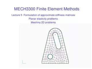
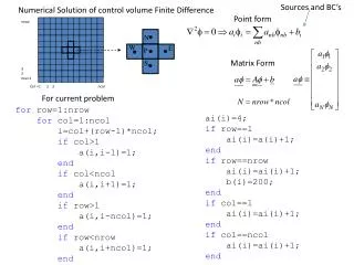
GRIDS .
GRIDS .
Software • Visual Modflow (VMF) is based on the finite-difference code MODFLOW (Harbaug & McDonald 1988) and contains four integrated modules: • MODFLOW – Groundwater flow model. • ZONE BUDGET – Water balance within user defined zones. • MODPATH – Particle tracing. • MT3D (Model Tracking 3D) – Substance or solute transport.
Typical MODFLOW grid and lay-out Active cell . In active cell
Conceptual ModelExample: North Gaza • Model Domain and Boundaries the model domain is usually chosen to fit stable boundary conditions. Example: The Model Domain encloses an area of 17x23 km in the northern part of the Gaza Strip
BLWWT Site NGWWT Site Conceptual ModelExample: North Gaza • Model Grid The model domain is divided into a horizontal grid with cell size 50x50 m at the BLWWTP site and 20x20 m at the new NGWWTP site and the cell size then increases gradually towards the model boundaries
Conceptual Model Boundaries • No-flow Boundary • Usually taken normal to water level contours • Constant head boundary • Where head is expected to be constant (no change) during the model simulation duration • Examples ??? • Variable head boundary • Usually taken when head is changing uniformly with time • Examples (river ?)
Water Table Conceptual Model • The lower boundary of the model consists of Saqiye’s surface • The upper boundary is the ground surface
Conceptual Model • Eastern Boundary • Aquifer outcrop ? • North and South • Stable no-flow boundaries • Western Boundary • Sea ?
Exercise – Steady State Model • Develop a one layer flow model for 1km*1km*80m rectangular aquifer (50mx50m cells) • Boundaries:” • Western: constant head = 0 m • Eastern: constant head = 5m • North and south: no flow • Recharge: 200mm/year • Kx=30m/d, Ky=10m/d • One well: • Screen: -5 m , -35m, Q = 2000m3/day • View the results: Water level, cross section, flow direction, etc • Refine the grid around the well • Add layer & Change properties in the layers