Download
1 / 15
150 likes | 386 Vues
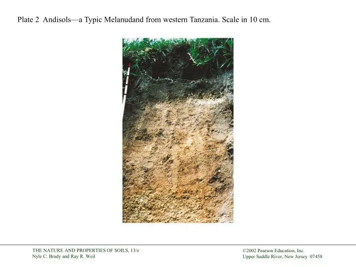
Plate 2 Andisols—a Typic Melanudand from western Tanzania. Scale in 10 cm. Plate 10 Spodosols—a Humic Cryorthod from southern Quebec. Albic horizon at about 10 cm. Bar = 10 cm.

E N D
Plate 2 Andisols—a Typic Melanudand from western Tanzania. Scale in 10 cm.
Plate 10 Spodosols—a Humic Cryorthod from southern Quebec. Albic horizon at about 10 cm. Bar = 10 cm.
Plate 11 Ultisols—a Typic Hapludult from central Virginia showing metamorphic rock structure in the saprolite below the 60-cm-long shovel.
Plate 13 Typic Argiustolls in eastern Montana with a chalky white calcic horizon (Bk and Ck) overlain by a Mollic epipedon (Ap, A2, and Bt).
Plate 15 A Typic Plinthudult in central Sri Lanka. Mottled zone is plinthite, in which ferric iron concentrations will harden irreversibly if allowed to dry.
Plate 16 A soil catena or toposequence in central Zimbabwe. Redder colors indicate better internal drainage. Inset: B-horizon clods from each soil in the catena.
Plate 17 Uneven water infiltration and movement in a sandy soil due to hydrophobic organic coatings.
Plate 18 The darker surface soil was brushed aside to expose a hydrophobic layer caused by burning the chaparral vegetation. Water beads up rather than soaking into this layer. See page 300.
Plate 19 The boundary between the Oe and the E horizons of a forested Ultisol.
Plate 20 The effect of moisture on soil color. Right side of this Mollisol profile was sprayed with water.
Plate 21 Effect of poor drainage on soil color. Gray colors and red redox concentrations in the B horizons of a Plinthaquic Paleudalf.
Plate 22 The 10YR hue page of a Munsell color book. The standard notation is handwritten for the color with hue 10YR, value 5, and chroma 6.
Plate 23 Road cut in southern Brazil exposing the profile of an Udalf with a sombric horizon. Humid, high-altitude tropical and subtropical mountains are the typical environments for the formation of this dark, humus-rich subsurface horizon.
Plate 24 Thick clay skins or argillans in an argillic Bt horizon. Image made from a very thin, polished slice of soil, magnified with a petrographic microscope using plain polarized light (left) and cross-polarized light (right). Note the thin layers of illuvial clay.
Plate 25 Connecticut River valley in western Massachusetts. Note variable alluvial soils and presence of riparian forest buffer along the river bank.