Download
1 / 1
10 likes | 71 Vues
Potential Mountain Lion Habitat on the Domain and Barriers to its Access Mary Mazyck, Catherine Bartenstein, Charlie Williams, and Elizabeth Wilson Department of Biology and Environmental Studies Program

E N D
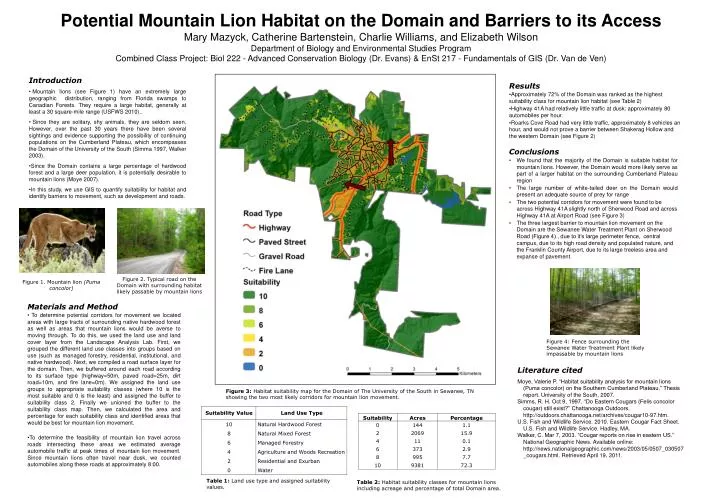
Potential Mountain Lion Habitat on the Domain and Barriers to its Access Mary Mazyck, Catherine Bartenstein, Charlie Williams, and Elizabeth WilsonDepartment of Biology and Environmental Studies Program Combined Class Project: Biol 222 - Advanced Conservation Biology (Dr. Evans) & EnSt 217 - Fundamentals of GIS (Dr. Van de Ven) • Introduction • Mountain lions (see Figure 1) have an extremely large geographic distribution, ranging from Florida swamps to Canadian Forests. They require a large habitat, generally at least a 30 square-mile range (USFWS 2010).. • Since they are solitary, shy animals, they are seldom seen. However, over the past 30 years there have been several sightings and evidence supporting the possibility of continuing populations on the Cumberland Plateau, which encompasses the Domain of the University of the South (Simma 1997, Walker 2003). • Since the Domain contains a large percentage of hardwood forest and a large deer population, it is potentially desirable to mountain lions (Moye 2007). • In this study, we use GIS to quantify suitability for habitat and identify barriers to movement, such as development and roads. • Results • Approximately 72% of the Domain was ranked as the highest suitability class for mountain lion habitat (see Table 2) • Highway 41A had relatively little traffic at dusk: approximately 80 automobiles per hour. • Roarks Cove Road had very little traffic, approximately 8 vehicles an hour, and would not prove a barrier between Shakerag Hollow and the western Domain (see Figure 2) • . • Conclusions • We found that the majority of the Domain is suitable habitat for mountain lions. However, the Domain would more likely serve as part of a larger habitat on the surrounding Cumberland Plateau region • The large number of white-tailed deer on the Domain would present an adequate source of prey for range • The two potential corridors for movement were found to be across Highway 41A slightly north of Sherwood Road and across Highway 41A at Airport Road (see Figure 3) • The three largest barrier to mountain lion movement on the Domain are the Sewanee Water Treatment Plant on Sherwood Road (Figure 4) , due to it’s large perimeter fence, central campus, due to its high road density and populated nature, and the Franklin County Airport, due to its large treeless area and expanse of pavement. Figure 2. Typical road on the Domain with surrounding habitat likely passable by mountain lions Figure 1. Mountain lion (Puma concolor) • Materials and Method • To determine potential corridors for movement we located areas with large tracts of surrounding native hardwood forest as well as areas that mountain lions would be averse to moving through. To do this, we used the land use and land cover layer from the Landscape Analysis Lab. First, we grouped the different land use classes into groups based on use (such as managed forestry, residential, institutional, and native hardwood). Next, we compiled a road surface layer for the domain. Then, we buffered around each road according to its surface type (highway=50m, paved road=25m, dirt road=10m, and fire lane=0m). We assigned the land use groups to appropriate suitability classes (where 10 is the most suitable and 0 is the least) and assigned the buffer to suitability class 2. Finally we unioned the buffer to the suitability class map. Then, we calculated the area and percentage for each suitability class and identified areas that would be best for mountain lion movement. • To determine the feasibility of mountain lion travel across roads intersecting these areas we estimated average automobile traffic at peak times of mountain lion movement. Since mountain lions often travel near dusk, we counted automobiles along these roads at approximately 8:00. Figure 4: Fence surrounding the Sewanee Water Treatment Plant likely impassable by mountain lions Literature cited Moye, Valerie P. “Habitat suitability analysis for mountain lions (Puma concolor) on the Southern Cumberland Plateau.” Thesis report. University of the South, 2007. Simms, R. H. Oct 9, 1997. “Do Eastern Cougars (Felis concolor cougar) still exist?” Chattanooga Outdoors. http://outdoors.chattanooga.net/archives/cougar10-97.htm. U.S. Fish and Wildlife Service. 2010. Eastern Cougar Fact Sheet. U.S. Fish and Wildlife Service. Hadley, MA. Walker, C. Mar 7, 2003. “Cougar reports on rise in eastern US.” National Geographic News. Available online: http://news.nationalgeographic.com/news/2003/05/0507_030507_cougars.html. Retrieved April 19, 2011. Figure 3: Habitat suitability map for the Domain of The University of the South in Sewanee, TN showing the two most likely corridors for mountain lion movement. Table 1: Land use type and assigned suitability values. Table 2: Habitat suitability classes for mountain lions including acreage and percentage of total Domain area.