Download
1 / 38
440 likes | 782 Vues
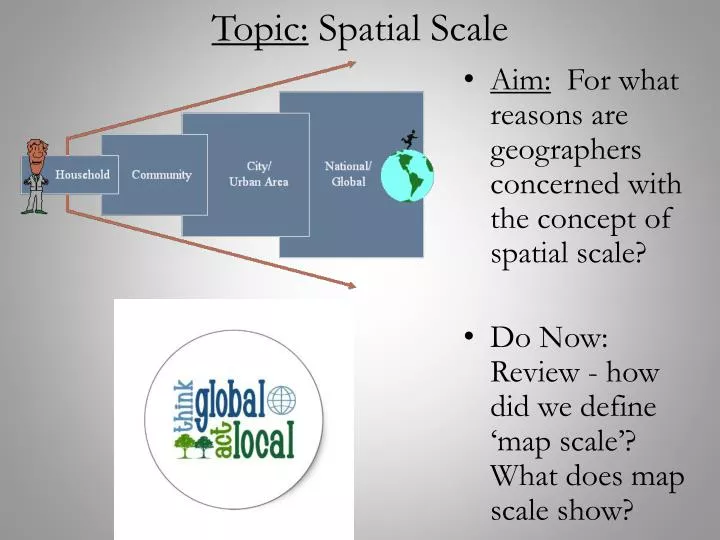
Topic: Spatial Scale. Aim: For what reasons are geographers concerned with the concept of spatial scale? Do Now: Review - how did we define ‘map scale’? What does map scale show?. Standard 3: Human Geography.

E N D
Topic: Spatial Scale • Aim: For what reasons are geographers concerned with the concept of spatial scale? • Do Now: Review - how did we define ‘map scale’? What does map scale show?
Standard 3: Human Geography Recognize and Interpret at Different Scales Relationships Among Patterns and Processes: • Geographical analysis requires a sensitivity to scale -- not just as a spatial category but as a framework for understanding how events and processes at different scales influence one another. Thus, students should understand that the phenomena they are studying at one scale (e.g., local) may well be influenced by developments at other scales (e.g., regional, national, or global). They should then look at processes operating at multiple scales when seeking explanations of geographic patterns and arrangements.
Scale: has 2 distinct meanings in geography • Map Scale: is the distance on a map compared to the distance on the Earth • Territorial Scale: is the territorial extent of something – exists on global, regional, local, and individual levels
Scale is Critical to Critical Thinking Using reason to decide what to believe or do. Assessing the authenticity, accuracy, or worth of knowledge claims and arguments. Applying careful, precise, persistent and objective analysis of any knowledge claim or belief to judge its validity.
1. Local Scale Provides more detailed, specific information about a place • Absolute location • Site • Situation
2. Regional Scale Several neighboring countries or areas that share important features • Formal Region • Functional Region • Vernacular Region
3. Global Scale The earth as a whole (common patterns and trends) • Globalization: interdependence of people all around the world (the earth is shrinking)
Why Scale Matters… • Different Scales show different patterns • Different observations can be made about phenomenon • Essentially, looking at things at different scales tells different stories • For example, take test scores…
Reading from “The Power of Place” • Based on what we just discussed, how is de Blji speaking about the idea of scale?
Spatial Scale: Geographers consider different scales when studying places on earth. Large Scale vs. Small Scale
Which has a larger scale? 1/5,000 1/50,000 or
Which has a smaller scale? 1:25,000,000 1:2,500 or
Which has the largest scale? 1 2 3 4
Which has the smallest scale? 1 2 3 4
Scale and the AP Exam: • For example, the national passing rate for this course at a national level was about 52% • At a local scale, however, Sewanhaka School District had between 80-86% passing rate • At an individual level, some students fail, some pass
Scale Example: China’s Population: • Though true that China is the most populated country on Earth, examining population at different scales allows us to analyze population on different levels
Regional variations, however, Over 90 percent of the Chinese population live on less than 40 percent of the land. To the left is a map showing the distribution and density of China's population. One tiny dot indicates 50,000 people.
2 More Examples… • Thinking of the examples we just discussed, apply the concepts to 2 other examples: politics and poverty…
Scale & Tourism: • Tourism takes place at a variety of geographical scales. • For example, travel to the less developed world by comparatively wealthy individuals from developed nations has become popular, spurred by the growing forces of globalization. • This creates a generalized pattern whereby tourist-generating nations are located in the Northern Hemisphere and tourist-receiving destinations are found in the Southern Hemisphere. Global climate patterns also figure into the North-South movement of tourists. A clear preference for warm, sunny, beach- oriented locations is evident. When months of winter weather chill North America, it is the tourist in-season for the tropical Caribbean.
Map Scale: A comparison of distances on a map to distances on Earth • Fractional Scale: numerical ratio; e.g. 1/24,000 or 1:24,000 (both numbers use same units) • Written or Verbal Scale: written statement; e.g. “1 inch equals 1 mile” (different units) • Graphic Scale: bar line marked to show distance (need to use ruler)
Used in German schools before World War I. Note the use of the fractional scale. Why do you think the fractional scale was used instead of a graphic scale? What do you notice about these two maps?
Comparative Size of Germany and USA in 1914: If we maintain the same scale for both countries, this is how they compare in size.
What kind of scale? “One inch to 5 miles” Verbal scale One inch on the map equals five miles on the surface of the earth. Note the different units: inch vs. mile.
What kind of scale? 1:316,800 or 1/316,800 Fractional Scale No unit of measurement is shown because the unit can be anything. If it is inches, then the statement is read this way: “One inch on the map equals 316,800 inches on the surface of the earth.”
What kind of scale? Graphic Scale
Would you agree that the same map is shown at two different scales? If so, the fractional scale on each map cannot be correct for both maps. In fact, it is correct for neither (it was correct for the size of the map that appeared in the text which carried this illustration.)
An advertisement (Conde Nast Traveler) from 2007. When scale is not shown on a map – beware! On this map, Peru has clipped off Alaska so as not to show the Pacific Ocean at scale. The Japanese are wealthy enough to be world tourists (and they have historical connections with Peru). Their trip across the Pacific to Peru seems only as long as Europeans’ trip across the Atlantic.
“Western Samoa The Cradle of Polynesia 1995” How could there be a reference to scale on this map. Samoa is made to look larger than the USA. There are other problems, too: directional relationships are not true.
“Western Samoa The Heart of Polynesia 1995” A pattern develops, “lying with scale” (“lying with maps”) is something that all small island nations do. Here is the second example from Western Samoa.
“The Fiji Islands” 1996 travel brochure. Not just Samoa distorts scale to increase its gravity on the world travel map, so does Fiji (in this case, the companies that serve Fiji’s tourist market).
Maps are often used to change perceptions. What is the scale of this map of the U.S.? What do we mean by perceptual scale? An entire genre of postcards is built around scale manipulations.
Spatial Scale: By breaking down scale, geographers can study the same phenomena at different levels • Local Scale • Regional Scale • Global Scale Which is the largest scale? Which is the smallest scale?
Scale Displaying the same geographical features at various scales may also depict misleading results.
This map shows the total number of African-Americans per state. Examine Georgia..
In the previous slide, Georgia had one of the highest number of African-Americans, but a closer look tells a different picture. The dark red is the Atlanta metropolitan area.
Using Census Tracts of the Atlanta Metropolitan Area, a different scale gives different results.