Download
1 / 1
10 likes | 115 Vues
Structure and Propagation of the Outer Ebb-Tidal Front of the Columbia River Plume. OS22B-0268: Philip Orton, David Jay , OHSU / Oregon Graduate Institute, Hydrodynamic Processes and Ecosystems Lab, http://www.ese.ogi.edu/~jaylab.

E N D
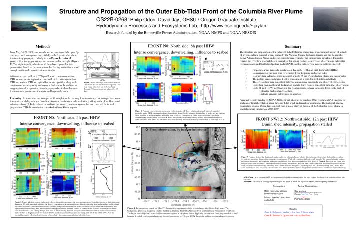
Structure and Propagation of the Outer Ebb-Tidal Front of the Columbia River Plume OS22B-0268: Philip Orton, David Jay , OHSU / Oregon Graduate Institute, Hydrodynamic Processes and Ecosystems Lab, http://www.ese.ogi.edu/~jaylab Research funded by the Bonneville Power Administration, NOAA-NMFS and NOAA-NESDIS FRONT N8: North side, 8h past HHW Intense convergence, downwelling, influence to seabed Methods Summary The structure and propagation of the outer ebb-tidal Columbia plume front was examined as part of a study of juvenile salmon survival at sea, funded by the National Marine Fisheries Service and the Bonneville Power Administration. Winds and ocean currents were typical of the summertime upwelling-dominated regime, but riverflow was well below normal for the spring freshet. Using vessel observations, helicopter reconnaissance, and Synthetic Aperture Radar (SAR) satellite data, several general patterns emerged: • Propagation was generally similar each day, up to ~10 h past high-high water (HHW) • Convergence at the front was very strong, from the plume and ocean sides • Downwelling velocities were measured at up to 35 cm s-1, subducting plume and ocean water • The pattern suggested plume front propagation as a bore, but with rotational effects • These velocities were consistent with two-dimensional continuity and observed convergence • Upwelling occurred behind the front, at slightly lower values, consistent with SAR observations • Up to 8h past HHW, in 40m depth, the front appeared to have influence down to the seabed - Elevated backscatter, velocities - Salinity gradient below front to near bed A project recently funded by NOAA-NESDIS will allow us to purchase 10 m resolution SAR imagery for analysis of frontal evolution under differing tidal, wind, and riverflow conditions. The National Science Foundation Coastal Ocean Program will fund a major study of the role of the Columbia River plume in coastal primary production, 2003-2007. From May 24-27, 2001, two vessels and an occasional helicopter fly-over were used to map successive tidally-pulsed greater-ebb plume fronts as they propagated radially to sea (Figure 1; center of poster). Key forcing parameters are summarized to the right (Figure 2). The highest-quality data from all four days is pooled in this presentation, based on the assumption that forcing variability is small enough that frontal characteristics are similar. A fisheries vessel collected CTD profiles and continuous surface CTD measurements. A physics vessel collected continuous surface CTD and vertical CTD and optical backscatter profiles, along with continuous current velocity and acoustic backscatter. In addition to mapping frontal progression, sampling approaches included across-front transects, plume-axis transects, and large-scale maps. Period of front-study e riverflow Wind vector key: Eastward, 10 m/s b a Predicted tide, Columbia River mouth Figure 2: Wind, tide range, and riverflow were all similar over the four-day front-tracking study. The river output is the flow rate at Beaver Army Terminal, 50 km upstream, and is lagged by 0.5 days. c d f Processing: Acoustic data are averages of 80 samples, so have a very low uncertainty, but averages over some fine-scale variability near the front-line. Acoustic resolution is indicated with gridding in the plots. Horizontal velocities above (A,B) have been rotated into the frontal coordinate system, but not corrected for frontal progression. CTD data resolution is marked with tracklines in plots. Figure 4: Frames a-c show velocity and acoustic backscatter data. (d) shows salinity and optically-derived suspended particular matter (SPM) concentration data with a different X and Z scale, with clear downwelling of freshwater and particles at the frontline, as well as upwelling behind the front. (e) gives a comparison of frontal progression in the cross-front dimension (X), with horizontal velocities. (f) shows the difference between the salinity profiles several hundred meters to either side of the front. There is a substantial cross-frontal salinity difference all the way to the seabed, as total depth is 35 m. FRONT N5: North side, 5h past HHW Intense convergence, downwelling, influence to seabed FRONT NW12: Northwest side, 12h past HHW Diminished intensity, propagation stalled a b a b c g ocean plume front h c d Figure 5: Frames a-b show that the plume layer has shallowed substantially, and velocity data (not pictured) show that the front has ceased its forward movement into the prevailing southward ocean currents. While full-resolution SAR data is still ‘on order’ for our newly funded project, a preliminary analysis (c) was conducted with down-sampled data from the western end of the front shown in Figure 1. The ocean and plume have different backscatter signatures, a common indicator of differing water masses. Elevated NCRS backscatter at the frontline indicates convergence, while low backscatter immediately behind the front (-250m) indicates divergence (Vogelzang et al., Int. J. Remote Sensing, 1997). While these down-sampled data have too coarse a resolution for more than a qualitative analysis, this pattern is similar to those found in our shipboard surveys. i QUESTION: Up to ~8h past HHW, surface water in the plume converges on the front -- does this force most juvenile salmon into the front?ANSWER: The result is strongly dependent upon the depth at which the organism resides, which is poorly understood. e f Assumptions Typical Observations Mean horizontal salmon swim velocity is zero Salmon “ejected” from river in ebb tide Sea surface Vfront Plume Vplume>Vfront Vocean Vpycnocline Pycnocline Base Figure 3: Frames a-f show acoustic backscatter, velocity, shear and convergence. (g) gives a comparison of frontal progression in the front-normal dimension (X), with horizontal velocities. (h) shows a comparison of the measured downwelling profile at the front, and upwelling profile behind the front with profiles computed from continuity (assumes along-front uniformity). (i) shows actual vertical velocities as measured nearby with high resolution and accuracy, with the vessel maintaining position in the frontline. Profiles of salinity are not available for this transect, but the cross-frontal surface (3m) salinity changed from 20 to 31 while crossing the front. Studies have shown that the vertical backscatter maximum tracks the base of the plume due to subduction of bubbles and other matter (Marmorino and Trump, JGR 101(C11): 25661, 1996). Note the elevated backscatter below the front (f) down to the seabed -- this was a common feature below the fronts. Results Case A: Salmon in top 2m -- find front 6.5 hours later Case B: Salmon in pycnocline -- do not find front Figure 1: Front-tracking map from May 27, showing the progression of the front in hours after higher-high water. The background grayscale image is a satellite Synthetic Aperture Radar (SAR) image from a different day with similar conditions. The bright band (high backscatter) delineates convergence at the plume fronts. Typically, the northern front progressed at ~1 ms-1 between 4 and 8h, and eventually ceased forward movement by 12h past HHW due to the ambient southward ocean currents.