Download
1 / 24
240 likes | 313 Vues
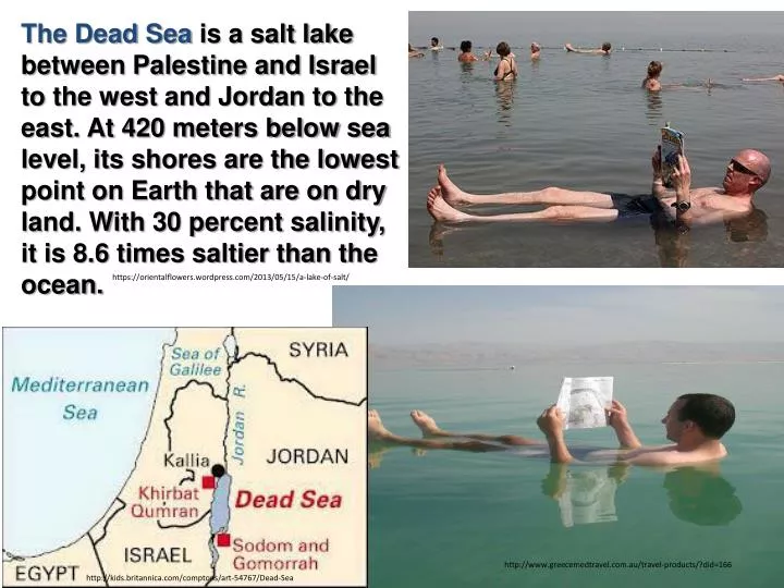
The Dead Sea is a salt lake between Palestine and Israel to the west and Jordan to the east. At 420 meters below sea level, its shores are the lowest point on Earth that are on dry land. With 30 percent salinity, it is 8.6 times saltier than the ocean.

E N D
The Dead Sea is a salt lake between Palestine and Israel to the west and Jordan to the east. At 420 meters below sea level, its shores are the lowest point on Earth that are on dry land. With 30 percent salinity, it is 8.6 times saltier than the ocean. https://orientalflowers.wordpress.com/2013/05/15/a-lake-of-salt/ http://www.greecemedtravel.com.au/travel-products/?did=166 http://kids.britannica.com/comptons/art-54767/Dead-Sea
The Official Rules of the Dead Sea http://www.halfwayanywhere.com/middle-east/israel/floating-at-the-dead-sea/
The Dead Sea Salt Deposits http://www.photoweeklyonline.com/spencer-tunick-dead-sea-installation/
Section 3: Distribution of Freshwater Freshwater 101 Quiz http://environment.nationalgeographic.com/environment/freshwater/freshwater-101-quiz/ Freshwater – Why Care? http://video.nationalgeographic.com/video/env-freshwater-whycare?source=searchvideo http://emergingmarketmusings.wordpress.com/2011/09/
Freshwater accounts for only some 6percent of the world's water supply, but is essential for human for what reasons? drinking, agriculture, manufacturing, and sanitation How much of global freshwater is found underground? two-thirds http://commons.wikimedia.org/wiki/File:Freshwater_Bay,_Newfoundland.jpg
26. (cont.) If you dig deeply enough anywhere on Earth, you will hit water. It is rarely a distinct waterbody(large caves in limestone aquifers are one exception). Rather, groundwater typically fills very small spaces (pores) within rocks and between sediment grains. http://fracfocus.ca/water-protection/groundwater-aquifers
27. What is the water table? The water table is the top of the saturated zone . It may lie hundreds of meters deep in deserts or near the surface in moist ecosystems. Water tables typically shift from season to season asprecipitationand transpiration levels change, moving up during rainy periods or periods of little transpiration andsinkingduring dry phases when the rate of recharge (precipitation minus evaporation and transpiration that infiltrates from the surface) drops. Intemperate regions the water table tends to follow surface topography, rising under hills where there is little discharge to streams and fallingunder valleys where the water table intersects the surface in the form of streams, lakes, and springs. http://www.nrcs.usda.gov/wps/portal/nrcs/detail/vt/soils/?cid=nrcs142p2_010594
These photos show how water tables typically shift from season to season as precipitation and transpiration levels change, moving up during rainy periods or periods of little transpiration and sinking during dry phases http://blakeandrews.blogspot.com/2009/06/rephotographing-marten.html
28. Above the water table lies the unsaturated zone, also referred to as the vadose zone, where the pores (spaces between grains) are not completely filled with water. Water in the vadose zone is referred to as soil moisture. http://www.dbstephens.com/Vadose_Zone_Hydrology.aspx
Water flowsupwardunder suction through small pores from the water table toward plant roots when evapotranspiration is greater than precipitation. After a rainstorm, water may recharge the groundwaterby saturating large pores and cracks in the soil and flowing very quickly downward to the water table. http://en.wikipedia.org/wiki/Infiltration_(hydrology)
30. Millions of people worldwide depend on groundwater stocks, which they draw from aquifers—permeable geologic formations through which water flows easily. Under natural conditions many aquifers are artesian: the water they hold is under pressure, so water will flow to the surface from a well without pumping http://www.geo.tcu.edu/faculty/donovan/10113%20karst%20revision/photoalbum/pages/Texas%20artesian%20spring_jpg.htm http://www.olyblog.net/other-95-artesian-wells-downtown-olympia
Aquifers may be either capped by an impermeable layer (confined) or open to receive water from the surface (unconfined). http://data.edwardsaquifer.org/display_education_portal_m.php?pg=education_springs_wells Confined aquifers are often artesian because the confining layer prevents upward flow of groundwater, but unconfined aquifers are also artesian in the vicinity of discharge areas. This is why groundwater discharges into rivers and streams. Confined aquifers are less likely to be contaminated because the impermeable layers above them prevent surface contaminants from reaching their water, so they provide good-quality water supplies
http://www.vaiwai.com/au/vaiwai-bottle/natural-artesian-waterhttp://www.vaiwai.com/au/vaiwai-bottle/natural-artesian-water
32. Water has an average residence time of thousands to tens of thousands of years in many aquifers, but the actual age of a water sample collected from a particular well will varytremendously within an aquifer. Shallow groundwater can discharge into streams and rivers in weeks or months, but some deep groundwater is millions of years old—as old as the rocks that hold the water in their pores. http://travelmines.blogspot.com/2013/04/100-must-see-incredible-places-around.html
http://travelmines.blogspot.com/2013/04/100-must-see-incredible-places-around.htmlhttp://travelmines.blogspot.com/2013/04/100-must-see-incredible-places-around.html Red Beach, Panjin, China: Located near the theLiaohe River of Panjin City in China. The name drawn from the color of the weeds which start growing during April or May remains green during the summer. In autumn, this weed turns flaming red, and the beach looks as if it was covered by an infinite red carpet that creates a rare red sea landscape. http://4.bp.blogspot.com/-oLhWjb1r8aM/UV638rR_cvI/AAAAAAAAAAs/ILFa5xzp0vY/s1600/red-beach-at-panjin-china.jpeg
The Colorado River winds 1,470 miles from the Rocky Mountains to the Gulf of California's Sea of Cortez—or did when its waters were more plentiful. http://environment.nationalgeographic.com/environment/freshwater/rivers/
32. Because of this distribution of residence times in aquifers, contaminants that have been introduced at the surface over the last century are only now beginning to reach well depths and contaminate drinking water in many aquifers. http://www.filterwater.com/asp/cs/well-water-and-ground-water-contamination.asp Indeed, much of the solute load (salt and other contaminants) that has entered aquifers due to increased agriculture and other land use changes over the last several centuries has yet to reach discharge areas where it will contaminate streams and lakes.
33. Ice sheets and glaciers are not always thought of as freshwater sources, but they account for a significant fraction of world reserves. Nearly 90 percent of the water in icecaps and glaciers is in Antarctica, with another 10 percent in the Greenland ice sheet and the remainder in tropical and temperate glaciers. Earth's ice sheets constantly expand and contract as the planet's climate fluctuates. During warm periods ice sheets melt and sea levels rise, with the reverse occurring when temperatures fall. Water may remain locked in deep layers of polar ice sheets for hundreds of thousands of years View Video of glacier calving https://www.youtube.com/watch?v=hC3VTgIPoGU
Alaska's Hubbard Glacier is advancing at the rate of seven feet per day!
A stunning aerial view of the Elephant Foot Glacier’ in Greenland. The mountains on either side are thousands of feet high, which gives some idea of the gargantuan scale. http://www.travelsupermarket.com/blog/glaciers-that-look-like-art/
The Briksdalbreen Glacier, Norway, looks less like a natural phenomena than something cooked up by a Hollywood Studio. The jagged, beauty of the ice flow is heightened when you notice the tiny, tiny people at the end. http://www.travelsupermarket.com/blog/glaciers-that-look-like-art/
34. Riverscontain a relatively small share of fresh water, but the flux of water down rivers is a large part of the globalhydrologic cycle and they are centrally important in shaping landscapes. Their flow erodes solid sediment and carries it toward the sea, along with dissolved minerals. These processes shape land intovalleysand ridges and deposit thick layers of sediment in flood plains. Over geologic time the erosion caused by rivers balances the uplift driven by plate tectonics. Much of Earth's freshwater flow passes through several of the planet's largest rivers: the Amazon carries 15 percent of total river flow on Earth, the Congocarries3.5percent, and rivers that flow into the Arctic Ocean carry 8 percent. The average residence time of water in rivers is less than a year.
The Amazon carries 15 percent of total river flow on Earth. http://peakwater.org/tag/amazon-river/ http://en.wikipedia.org/wiki/Amazon_River
The Congo carries 3.5 percent of the total river flow on Earth http://en.wikipedia.org/wiki/Congo_River http://patrizioradaelli.blogspot.com/2013/10/national-geographic-magazine-wallpapers.html