Download
1 / 1
10 likes | 118 Vues
Mapx — An Object-Oriented Geographic Coordinate Transformation Library. Ken Knowles, Ross Swick, Rob Bauer University of Colorado, Boulder.

E N D
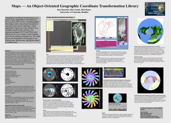
Mapx — An Object-Oriented Geographic Coordinate Transformation Library Ken Knowles, Ross Swick, Rob Bauer University of Colorado, Boulder Geographic coordinate transformations are used in many applications at the National Snow and Ice Data Center, including gridded data display tools, data processing systems, and online area search interfaces. These applications require accurate, efficient, and reusable transformation routines. The standard packages GCTP and PROJ were difficult to use in our modern multi-threaded event driven software architectures. The mapx library was developed to fill this gap for our internal uses. We are now offering the library to outside users. Example applications built with the mapx library — Global Land Cover Characterization (GLCC) in EASE-Grid This is a 25km EASE-Grid version of the 1km GLCC produced by EROS Data Center (EDC) from AVHRR. The EDC version is in the Goode Interrupted Homolosine projection and is 40,031 by 17,347 pixels (660 megabytes). The 1km product characterizes each pixel as 1 of 17 IGBP classes. The EASE-Grid version has 1 layer for each category and gives the percent of that pixel covered by each category. Resamp was used to produce 12.5km and 25km versions of all 3 EASE-Grid projections. regrid and resamp Resample one grid to another. It's quite easy to write a configuration file for existing gridded data sets and interpolate the data to a new grid. The software supports several interpolation schemes including, bilinear, cubic convolution, drop in the bucket, inverse distance squared, and nearest neighbor. Features: The main benefit of an object oriented architecture for the map transformation libarary is that each map transformation is independent. Often, in the available standard packages only one transformation can be initialized at a time. In mapx the initialization of a new map transformation has no effect on existing mapx objects. This is an important feature where concurrent processing is required. Examples include -- simultaneously ingesting data from different maps, pixel by pixel conversion of one map to another, or an on-line map server with multiple projection options. Transforms: The following transformations are currently implemented: Azimuthal Equal-Area Cylindrical Equal-Area Cylindrical Equidistant Goode Interrupted Homolosine Lambert Conformal Conic Mercator Mollweide Orthographic Polar Stereographic Sinusoidal The design of the library allows for easy addition of new transformations. Most transforms have both spherical and ellipsoidal versions. The initialization allows for the use of different datum to describe the spheroid and is not restricted to the Earth (you could easily use mapx on the moon or Mars, for example). Accuracy: The coordinate transformations in mapx are, for the most part, taken from Snyder and tested against the numerical examples he gives in Appendix A. Further, all transformations are tested against their inverse and are accurate to within 1 meter. Application Program Interface (API): Both the C and Java versions provide constructors, a destructor, A forward transformation (from latitude, longitude to map coordinates), an inverse transformation (map coordinates to latitude, longitude), and a test to determine if a point is within a map. Reference: Snyder, John P., Map Projections Used by the U. S. Geological Survey, 1982. popview An X based image display tool for OLS native format files including both full-resolution and browse data. The mapx library was used to add toggle-able overlays of coastlines, rivers, political boundaries, and graticule, interactive reading of latitude, longitude, and a live link to gomap. limb A browser for large image maps. Image maps are image files which have been rectified to a gridded map projection. This browser allows the user to roam around inspecting the image and retrieving coordinates for later use (for example to specify a region of interest). One nice feature is the ability to integrate a digital elevation model (DEM) with the image map. Elevation is displayed along with the coordinate information and elevation contour lines can be drawn over the full resolution image. The DEM need not be in the same projection as the image map. Here the Greenland SAR Mosaic is a 100 meter polar stereographic image map while the DEM is a .02 by .05 degree cylindrical equidistant grid. gomap An X based graphical orbit finder, displays orbit and currently viewed scene on user-selectable map projection with optional coastlines, rivers, political boundaries, and graticule. User-definable orbit parameters allow display of the ground track for any sensor on any sun-synchronous satellite. NOAA/NASA Pathfinder EASE-Grid Brightness Temperatures The EASE (Equal-Area Scalable Earth) Grid is a group of three projections, azimuthal equal-area for Northern and Southern Hemispheres, and cylindrical equal-area for global, at multiple grid spacings, currently 100km to 1.25km. The mapx library is used in the processing system which applies optimal interpolation techniques to place SSM/I and SMMR brightness temperatures into the EASE-Grid. . International Permafrost Association Permafrost and Ground Ice Map This map summarizes current knowledge of the distribution and character of permafrost and ground ice in the Northern Hemisphere. Twenty different categories are used to distinguish permafrost extent and ground ice content. The map was originally published in ARC/Info format. The polygons were rasterized into the 12.5km EASE-Grid and then regrid was used to reduce the resolution to 25km EASE-Grid. Near-real time Ice & Snow Extent (NISE) This product, which is produced daily, shows the current global distribution of snow extent and sea ice concentrations. It is derived from passive microwave data (SSM/I) which is gridded by gsgrid. The snow algorithm requires data from one pass per day and uses nearest neighbor resampling, the sea ice concentration algorithm requires an average of all passes for the day and uses drop in the bucket resampling. Gsgrid easily accommodates both requirements. gsgrid Converts passive microwave swath data to gridded format. Input formats include: SSM/I Ta Tapes from RSI (Wentz format), SMMR Pathfinder Tbs, MSFC SSM/I Tbs. The use of the mapx library allows easy configuration of the output grid. Gsgrid is an important part of both the NISE and EASE-Grid SMMR processing systems as well as the custom request SSM/I gridding system. For more information on mapx at NSIDC, contact: Ken Knowles (303) 492-0644 (voice) (303) 492-2468 (fax) e-mail: knowlesk@colorado.edu http://cires.colorado.edu/~knowlesk GISMO A Java based interface to NSIDC's Polar Pathfinder gridded data products on the web. The GISMO interacts directly with the database of NSIDC holdings through JDBC. An interactive panel allows the user to specify a geographic subset of the requested data.