Download
1 / 15
150 likes | 272 Vues
Analysis of Current Hog Lagoon Locations and Possible F uture G rowth in North Carolina. Group 8: Ovik Banerjee, Stephen Bisher , Haley Fail, Casey Stern, Yvonne Yuen . Introduction. Hog farms distribution by States in U.S. . Hog Farms in NC. Total of 4148 swine lagoons in NC

E N D
Analysis of Current Hog Lagoon Locations and Possible Future Growth in North Carolina Group 8: Ovik Banerjee, Stephen Bisher, Haley Fail, Casey Stern, Yvonne Yuen
Introduction • Hog farms distribution by States in U.S.
Hog Farms in NC • Total of 4148 swine lagoons in NC • Highest density in Duplin, Sampson, and Wayne counties
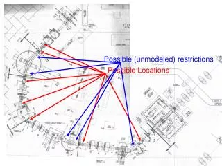
Suitability Analysis Purpose • To locate possible areas that are suitable for hog lagoons in the study area (Duplin, Sampson, and Wayne counties) • Identify existing hog lagoons with possible negative impacts on the environment or human health • Analysis is a weighted point scale calculation based on the area’s proximity to: • Schools • Hospitals • Wells • Surface water intake points • Possible flood hazard • Roads
Proximity to Points of Interest • Public buildings • Schools • Hospitals • Waters • Wells • Surface water intake points • Accessibility • Proximity to roads
Worst of the Worst • Within 750 meters of streams • And • Within 3000 meters of a school, hospital, or medical facility • Or • Within 750 meters of a well
Flood HazardAnalysis • 40 Total
Possible Air Pollution • Determined by slope aspect • SW wind direction scenario
Conclusion • Questions?