Download
1 / 1
20 likes | 148 Vues
Abstract Number B13B-0512. STATSGO2 (U.S.). SLC3.2&2.2 (Canada). The Unified North American Soil Map and Its Implication on the Soil Organic Carbon Stock in North America Shishi Liu*, Yaxing Wei, Wilfred M. Post, Robert B. Cook, Kevin Schaefer, and Michele M. Thornton

E N D
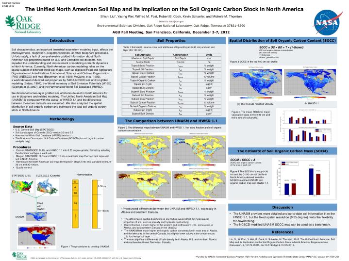
Abstract Number B13B-0512 STATSGO2 (U.S.) SLC3.2&2.2 (Canada) The Unified North American Soil Map and Its Implication on the Soil Organic Carbon Stock in North America Shishi Liu*, Yaxing Wei, Wilfred M. Post, Robert B. Cook, Kevin Schaefer, and Michele M. Thornton Shishi Liu: lius2@ornl.gov Environmental Sciences Division, Oak Ridge National Laboratory, Oak Ridge, Tennessee 37831-6290 AGU Fall Meeting, San Francisco, California, December 3-7, 2012 Harmonization 0-30cm Filled with HWSD 30-100cm …… Introduction Soil Properties Spatial Distribution of Soil Organic Carbon Content (SOCC) UNASM Soil characteristics, an important terrestrial ecosystem modeling input, affects the photosynthesis, respiration, evapotranspiration, or other biosphere processes. Unfortunately, a lack of comprehensive gridded information about North American soil properties based on U.S. and Canadian soil datasets, has impeded the understanding and improvement of modeling nutrients dynamics in North America. Currently, North American carbon modeling relies on the spatial subset of different world soil maps, such as digitized Food and Agriculture Organization – United Nations Educational, Science and Cultural Organization (FAO-UNESCO) soil map (Bouwman, et al. 1993; McGuire, et al. 1993), a world dataset of derived soil properties by FAO-UNESCO soil unit for global modeling (Batjes, 1997), the World Inventory of Soil Emission Potentials (WISE) (Gijsman et al. 2007), and the Harmonized World Soil Database (HWSD). We developed a two-layer gridded soil attributes dataset in North America for use in biosphere and related modeling. The Unified North American Soil Map (UNASM) is compared with the subset of HWSD 1.1 and the differences between these two datasets are evaluated. We also analyzed the spatial distribution of soil organic carbon and estimated the total soil organic carbon stock in North America. SOCC = OC × BD × T × (1-Gravel) OC: soil organic carbon concentration BD: soil bulk density T: thickness Gravel: gravel fraction Table 1 Soil depth, source code, and attributes of top soil layer (0-30 cm) and sub soil layer (30-100 cm). Figure 3 SOCC in the top 100 cm soil profile (b) HWSD1.1 (a) The NCSCD-modified UNASM Figure 4 The mean SOCC for major vegetation types in the 0-30 cm and the 0-100 cm soil profile. Methodology The Comparison between UNASM and HWSD 1.1 • Source Data • U.S. General Soil Map (STATSGO2) • Soil Landscapes of Canada (SLC) version 3.2 and 2.2 • Harmonized World Soil Database (HWSD) Version 1.1 • The Northern Circumpolar Soil Carbon Database (NCSCD) (for soil organic carbon analysis only) Figure 2 The difference maps between UNASM and HWSD 1.1 for sand fraction and soil organic carbon concentration. • Procedures • Convert STATSGO2, SLCs, and HWSD 1.1 into 0.25 degree gridded format by selecting the dominant soil type in each cell. • Merged STATSGO2, SLCs and HWSD1.1 into a seamless map that can best represent soil in North America. • Harmonize the North American soil map developed in stage 2 into two standard layers, 0-30 cm and 30-100cm. • Quality control. The Estimate of Soil Organic Carbon Mass (SOCM) SOCM = SOCC × A SOOC: soil organic carbon content A: the area of each cell Figure 5 The SOCM of the top 0-30 cm and the 0-100 cm soil profile in North America derived from the NCSCD-modified UNASM soil organic carbon map and HWSD 1.1. Discussion • Pronounced differences between the UNASM and HWSD 1.1, especially in Alaska and southern Canada • The difference in spatial distribution of soil texture would affect the hydrological properties of soil, such as porosity and hydraulic conductivity. • Gravel fraction is much higher in the western and northeastern U.S., some areas of Alaska, and southwestern Canada in the UNASM. • The UNASM has much higher soil organic carbon concentration in most area of Alaska, and the lake area in the central Canada, but slightly lower values in the conterminous U.S. for the top soil layer. • The most significant differences of bulk density lie in Alaska, U.S. and northern Alberta and southern Northwest Territories, Canada. • The UNASM provides more detailed and up-to-date soil information than the HWSD 1.1, but the fixed spatial resolution (0.25 degree) limits the flexibility for downscaling. • The NCSCD-modified UNASM SOCC map can be used as a benchmark. References Liu, S., W. Post, Y. Wei, R. Cook, K. Schaefer, M. Thornton, 2012. The Unified North American Soil Map and Its Implication on the Soil Organic Carbon Stock in North America. Biogeosciences Discussion, 9, 15175-15211, doi:10.5194/bgd-9-15175-2012. Figure 1 The procedures to develop UNASM. *Funded by NASA’s Terrestrial Ecology Program (TEP) for the Modeling and Synthesis Thematic Data Center (MAST-DC: project 09-TE09-26) ORNL is managed by the University of Tennessee-Battelle LLC under contract DE-AC05-00OR22725 with the U.S. Department of Energy