Download
1 / 12
120 likes | 247 Vues
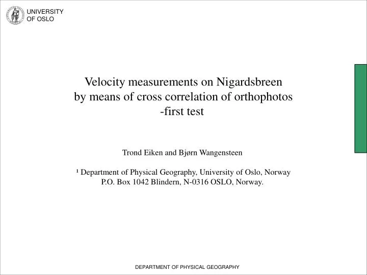
Velocity measurements on Nigardsbreen by means of cross correlation of orthophotos -first test Trond Eiken and Bjørn Wangensteen ¹ Department of Physical Geography, University of Oslo, Norway P.O. Box 1042 Blindern, N-0316 OSLO, Norway. UNIVERSITY OF OSLO.

E N D
Velocity measurements on Nigardsbreen by means of cross correlation of orthophotos -first test Trond Eiken and Bjørn Wangensteen ¹ Department of Physical Geography, University of Oslo, Norway P.O. Box 1042 Blindern, N-0316 OSLO, Norway. UNIVERSITY OF OSLO DEPARTMENT OF PHYSICAL GEOGRAPHY
UNIVERSITY OF OSLO Overview • Air photos of 10 outlets of Jostedalsbreen taken August 19th and 29th 2001 as part of the EU project Glaciorisk • One orthophoto of Nigardsbreen is generated for each day with a digital photogrammetric workstation (Z/I Imaging) • The cross-correlation software IMCORR, developed at NSIDC (US), is used for velocity calculations • The velocity data are interpolated and presented DEPARTMENT OF PHYSICAL GEOGRAPHY
UNIVERSITY OF OSLO The data set DEPARTMENT OF PHYSICAL GEOGRAPHY
UNIVERSITY OF OSLO Generating orthophotos I Done with DFW Z/I Imaging Match T Stereo model DTM (10m resolution) DEPARTMENT OF PHYSICAL GEOGRAPHY
UNIVERSITY OF OSLO Generating orthophotos II Stereo model + + DTM Orthophoto DEPARTMENT OF PHYSICAL GEOGRAPHY
UNIVERSITY OF OSLO Generating orthophotos III • A scale of 1:23.000 and 14μm scanningresolutionof the air photos gives a spatial resolution of approx. 30 cm for the air- and orthophotos. • The temporal resolution of 10 days is feasible for mapping the expected velocities (around 10 m displacement over the 10 day period). DEPARTMENT OF PHYSICAL GEOGRAPHY
UNIVERSITY OF OSLO IMCORR • Uses a fastFourier-transform version of the normalized cross-covariance method (see Berenstein, 1983). • Originally developed for locating tie-point pairs to coregister images. • If the images are already coregistred it could be used to find the displacement of moving features. • Mainly used with Landsat TM images (Ice streams in Antarctica etc.) DEPARTMENT OF PHYSICAL GEOGRAPHY
UNIVERSITY OF OSLO IMCORR • Parameters: search ship size, reference ship size and grid size • For every grid point, a correlation index is calculated for every location in the search ship that fits the reference ship. search ship (ortho 2) reference ship (ortho1) • The program returns a file containing the location of the reference ship in the first orthophoto and the location where the best match was found (if found) for this reference ship within the search ship in the second orthophoto DEPARTMENT OF PHYSICAL GEOGRAPHY
UNIVERSITY OF OSLO IMCORR • Parameters used: • grid size: 40 pixels (12 m) • search chip size: 128 pixels (38,4 m) • reference ship size: 16 pixels (4,8 m) • Due to the capability of the program the orthophoto had to be divided into 9 sub scenes. • A programming bug(?) also creates a systematic error in the location of the output. • Over half of the points located on the glacier surface are matched. • Interpolating of the data (IDW) is done to calculate values for the missing points. A median filter have also been applied to enhance the results. DEPARTMENT OF PHYSICAL GEOGRAPHY
August 19th August 29th