Download
1 / 1
10 likes | 101 Vues
stream gage. water balance instrumentation. met station. meadow transects. 20. 25. 30. 5. 15. August. September. snowmelt. ET. 2007. FIBER OUT OF WATER. snowmelt. 30. ET. 25. 20. Temperature, o C. 15. MEADOW POOL AT UPPER END OF DTS CABLE.

E N D
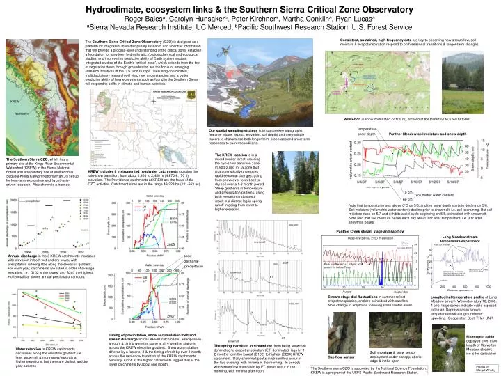
stream gage water balance instrumentation met station meadow transects 20 25 30 5 15 August September snowmelt ET 2007 FIBER OUT OF WATER snowmelt 30 ET 25 20 Temperature, oC 15 MEADOW POOL AT UPPER END OF DTS CABLE DEPPRESSIONS IN STREAM TEMPERATURE INDICATIVE OF GROUNDWATER UPWELLING 10 5 ICE BATH temperature 0 200 400 600 800 1000 Distance upstream, m snow depth oC volumetric water content ET snowmelt 10 cm volumetric water content 60 cm Hydroclimate, ecosystem links & the Southern Sierra Critical Zone ObservatoryRoger Balesa, Carolyn Hunsakerb, Peter Kirchnera, Martha Conklina, Ryan LucasaaSierra Nevada Research Institute, UC Merced; bPacific Southwest Research Station, U.S. Forest Service Consistent, sustained, high-frequency data are key to observing how streamflow, soil moisture & evapotanspiration respond to both seasonal transitions & longer-term changes. The Southern Sierra Critical Zone Observatory (CZO) is designed as a platform for integrated, multi-disciplinary research and scientific information that will provide a process-level understanding of the critical zone, establish a foundation for long-term hydroclimatic, (bio)geochemical and ecological studies, and improve the predictive ability of Earth system models. Integrated studies of the Earth’s “critical zone”, which extends from the top of vegetation down through groundwater, are the focus of emerging research initiatives in the U.S. and Europe. Resulting coordinated, multidisciplinary research will yield new understanding and a better predictive ability of how ecosystems such as found in the Southern Sierra will respond to shifts in climate and human activities. KREW Wolverton Wolverton is snow dominated (2,100 m), located at the transition to a red fir forest. Our spatial sampling strategy is to capture key topographic features (slope, aspect, elevation, soil depth) and use multiple tracers to characterize both longer term processes and short term responses to current conditions. Panther Meadow soil moisture and snow depth The KREW location is in a mixed conifer forest, crossing the rain-snow transition zone (1,500-2,000 m), a zone that characteristically undergoes rapid seasonal changes, going from snowcover to wet soil to dry soil over a 1-2 month period. Steep gradients in temperature and precipitation patterns, along both elevation and aspect, result in a distinct lag in spring runoff in going from lower to higher elevation. The Southern Sierra CZO, which has a primary site at the Kings River Experimental Watershed (KREW) in the Sierra National Forest and a secondary site at Wolverton in Sequoia-Kings Canyon National Park, is set up for long-term exploratory and hypothesis-driven research. Also shown is a transect A central hypothesis is that the distribution of soil moisture throughout the catchments controls (bio)geochemical processes, including weathering and the extent of coupling among the carbon and, nitrogen cycles. KREW includes 8 instrumented headwater catchments crossing the rain-snow transition, from about 1,460 to 2,450 m (4,870-8,170 ft) elevation. The Providence catchments at KREW are the focus of the CZO activities. Catchment sizes are in the range 49-228 ha (121-563 ac). Note that temperature rises above 0oC on 5/6, and the snow depth starts to decline on 5/8. Soil moisture (volumetric water content) decline prior to snowmelt, i.e. soil is draining. But soil moisture rises on 5/7 and exhibits a diel cycle beginning on 5/8, coincident with snowmelt. Note also that soil moisture peaks each day about 3 hr after temperature, i.e. 3 hr after snowmelt peaks. Panther Creek stream stage and sap flow Long Meadow stream temperature experiment Base-flow period, 2150 m elevation 2005 Annual discharge in the 8 KREW catchments increases with elevation in both wet and dry years, with precipitation differing little along the elevation gradient. For each year, catchments are listed in order of average elevation, i.e., D102 is the lowest and B203 the highest. Horizontal bar shows annual precipitation amount. snow discharge precipitation Stream stage diel fluctuations in summer reflect evapotranspiration, and are coincident with sap flow. Note change in amplitude following small rainfall event. Longitudinal temperature profile of Long Meadow stream, Wolverton (July 10, 2008, 4 pm). large spikes indicate cable exposed to the air. Depressions in stream temperature indicate groundwater upwelling. Cooperator: Scott Tyler, UNR 2007 Timing of precipitation, snow accumulation/melt and stream discharge across KREW catchments. Precipitation amount & timing were the same at all 4 weather stations across the KREW elevation gradient. Snow accumulation differed by a factor of 3 & the timing of melt by over 1 month across the rain-snow transition of the KREW catchments. Similarly, runoff at the higher catchments lagged that at the lower catchments by about one month. Fiber-optic cable deployed over 1-km length of Wolverton Meadow stream; ice is for calibration The spring transition in streamflow, from being snowmelt dominated to evapotranspiration (ET) dominated, lags by 1-2 months form the lowest (D102) to highest (B204) KREW catchment. Daily snowmelt peaks in streamflow occur in the late evening, with minima in the morning. In periods with streamflow dominated by ET, peaks occur in the morning, with minima after noon. Water retention in KREW catchments decreases along the elevation gradient, i.e. later snowmelt & more snow/less rain at higher elevations, but there are distinct wet/dry year patterns Soil moisture & snow sensor deployment under canopy, at drip edge & in the open Sap flow sensor Photos by Margot Wholey The Southern sierra CZO is supported by the National Science Foundation. KREW is a program of the USFS Pacific Southwest Research Station.