Download

1 / 10
100 likes | 277 Vues
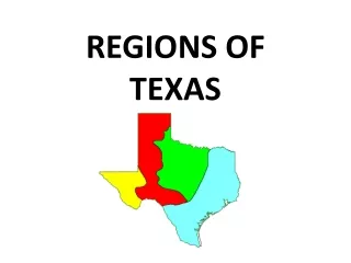
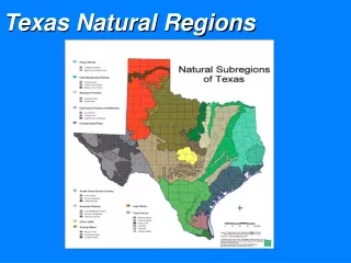
Texas Regions. Coastal Plains. 1. Land is flat to gently rolling a. 0 to 500 feet above sea level 2. Rich soil and mild, wet climate: a. Farming, ranching, timber industry 3. Coast and Ocean provide: a. Shipping b. Manufacturing c. Fishing. 4. South Texas Plain

E N D
Coastal Plains • 1. Land is flat to gently rolling • a. 0 to 500 feet above sea level • 2. Rich soil and mild, wet climate: • a. Farming, ranching, timber industry 3. Coast and Ocean provide: a. Shipping b. Manufacturing c. Fishing
4. South Texas Plain • a. Dry, savanna for ranching • b. Farming along Rio Grande: citrus, long growing season so far south 5. Mineral Resources: a. Oil, Natural Gas and coal for energy b. Salt and sulphur
6. Population: • a. Large Cities are Houston, Dallas, San Antonio and Austin (Capital) • b. Most populated region
North Central Plains • 1. Land • a. Flat to Rolling Hills to Steep hills and valleys • b. Some good soil for farming • c. Some soil too rocky 2. Economy: a. Farming, Ranching, including sheep and goats b. Oil and gas c. Manufacturing
3. Population: • a. Largest cities are Ft. Worth and Arlington
Great Plains • 1. Land: • a. High flat plains in Panhandle (Plateaus because elevation changes to form them) • b. Edwards Plateau (Texas Hill Country) • c. Region formed by Cap Rock escarpment in North and Balcones escarpment in South d. Palo Duro Canyon formed by escarpment and Red River
2. Economy • a. Farming (irrigation) • b. Ranching • c. Oil and Gas • d. Shipping (railroad) • 3. Population • a. small towns and ranches • b. Lubbock, Amarillo, Midland, Odessa
Mountains and Basins • 1. Mountains, Basins (low areas), dry, desert • 2. Guadalupe Peak: highest 8,749 feet • 3. Big Bend National Park • 4. Economy: • a. Mining: limestone, shale, clay, copper • b. Oil and gas • c. Manufacturing and shipping (with Mexico and Western United States)
Population: • a. El Paso: borders Mexico and New Mexico • Strong economic and cultural ties with both • b. Large Hispanic population