Download
1 / 16
160 likes | 247 Vues
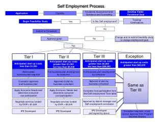
APPLICATION # 1779 Small Scale Future Land Use Map (FLUM) Amendment. Background and Location Map . Site Area - 2.75 +/- Acres Current Use – Vacant Current Zoning – SFR-3 Current FLUM – Residential Proposed FLUM – .37 acres Mixed-Use and 2.38 acres Greenbelt.

E N D
APPLICATION # 1779 Small Scale Future Land Use Map (FLUM) Amendment
Background and Location Map • Site Area - 2.75 +/- Acres • Current Use – Vacant • Current Zoning – SFR-3 • Current FLUM – Residential • Proposed FLUM – .37 acres Mixed-Use and 2.38 acres Greenbelt
EXISTING FUTURE LAND USE MAP • North- Mixed Use • West- Mixed use • South - Residential • East- Residential
EXISTING ZONING • North- Parks and Greenways, COM-2 • West- OFC-2 • South- Single Family Residential • East-Single Family Residential
EXISTING USES • North- Vacant, Retail • West- Office Use • South- Vacant • East- Single-family Residential
MAXIMUM DEVELOPMENT ANALYSIS • No significant impact on Maximum Development Potential • Increase of 3223 sq. ft. of non-residential use • Decrease of 26 dwelling units
PUBLIC FACILITIES IMPACT ANALYSIS • No significant impact on public facilities • Slight increase in demand for non-residential uses • Decrease in demand for residential uses
CONSISTENCY WITH COMPREHENSIVE PLAN • Consistent with policies regarding location of mixed use areas. • Consistent with economic development objectives • Proposal to designate 2.38 acres to Greenbelt provides additional protection for adjacent residential area.
FINDINGS • The proposed FLUM amendment is consistent with the Goals, Objectives, and Policies of the adopted Comprehensive Plan.
RECOMMENDATION Staff recommends approval of Application #1779. A Future Land Use Map (FLUM) amendment for a 2.75+/- acre parcel from Residential to .37 acres of Mixed Use and 2.38 acres of Greenbelt
Rezone Application #1783 Parcel ID No.18-11-31-0000-02010-0000 07-11-31-7081-0RPOF-0031
Zoning Request Summary Parcel 1 Existing Zoning: Proposed Zoning: General Office (OFC-2) General Commercial (COM-2) Acreage: Proposed Revised Acreage: 2.86+/- 2.86 > 3.23+/- (+.37+/-ac.) FLUM (Existing)FLUM (Proposed) Mixed Use Mixed Use Parcel 2 Existing Zoning: Proposed Zoning: Single Family Res. Preservation (PRS) (SFR-3) General Commercial (COM-2) AcreageProposed Revised Acreage 2.75+/- Preservation 2.38+/- General Commercial .37+/- FLUM (Existing) FLUM (Proposed) ResidentialGreenbelt
Rezoning Review: Analysis Summary Chapter 2; Section 2.05.05. ULDC – (Development Review) A. The proposed development associated with the rezoning request is not in conflict with or contrary to the public interest. B. The proposed development associated with the rezoning request is consistent with the Comprehensive Plan and the provisions of the Land Development Code C. The proposed development associated with the rezoning request is such that it should not result in a liability or hardship for the City. D. The proposed development associated with the rezoning request will not create an unreasonable hazard, or nuisance, or constitute a threat to the general health, welfare, or safety of the City’s inhabitants. E. The proposed development associated with the rezoning request must comply with all other applicable local, state and federal laws, statutes, ordinances, regulations, or codes
Rezoning Review: Analysis Summary Chapter 2; Section 2.06.03. ULDC (Rezoning Application Review) A. The proposed rezoning request is consistent with all adopted elements of the Comprehensive Plan and furthers the goals and objectives of the Comprehensive Plan. B. The proposed rezoning request does not degrade the environment or natural resources. C. The nature of the proposed rezoning request and the associated proposed development should not negatively impact the affected areas. D. The nature of the proposed rezoning request and the associated proposed development has demonstrated that affected public facilities and/or levels of service will not be impacted. E. The nature of the proposed rezoning request favorably affects circumstances and conditions of the area. F. The nature of the proposed rezoning request and the associated proposed development is compatible with proximate uses and development patterns, including impacts to health, safety, and welfare of surrounding residents. G. Adoption of the proposed rezoning request will accomplish a legitimate public purpose.
Area Map Site