Download
1 / 1
10 likes | 153 Vues
Method For Improved Fire Weather Forecast. Deb Ross and Jeanette Comstock Department of Physics and Astronomy, University of Montana. Introduction

E N D
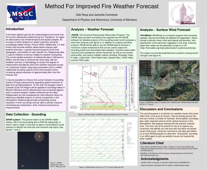
Method For Improved Fire Weather Forecast Deb Ross and Jeanette Comstock Department of Physics and Astronomy, University of Montana Introduction It has been agreed upon by the meteorological community that the current radiosonde network being the “backbone” for upper air observations has limited temporal and spatial samples. An increase in either temporal or spatial resolution would be exceedingly helpful (Kaiser, Pevear 2009). Additionally, it is well known that accurate weather observations improve spot weather forecasts, a special forecast issued to fit the time, topography, and weather of each specific fire. Radiosonde data is used to initialize numerical models for weather forecasting. The current spatial resolution of radiosonde data in Montana is 500km and the data is retrieved two times daily. We will establish and test a methodology to assess the degree of improvement provided by short-term weather forecasts issued for a particular location using input parameters from a mobile radiosonde sounding system at the same location hence increasing spatial resolution to approximately 8km from the forecast site. It may be possible to enhance the current network of sounding stations through improvements regarding spatial resolution of data from sounding balloons. To this end, the program used in Canada’s East Fire Region will be applied to soundings taken in Western Montana and its effectiveness then evaluated against other numerical weather models initialized with this data. Radiosondes are still considered the most effective means for obtaining a detailed analysis of vertical composition in the atmosphere. Radiosondes provide outstanding vertical resolution in their soundings and are able to directly measure simultaneously temperature, wind, moisture and pressure measurements. Analysis – Weather Forecast RAOB: The Universal Rawinsonde Observation Program: The GRAW data has been formatted to be ingested into the RAOB software for detailed analysis of the sounding ascent and to produce a short term forecast (see figure 3). In addition to a typical sounding analysis, RAOB will be able to use the GRAW data to forecast a maximum surface temperature that can be used to adjust the sounding profile and associated index displays. Inversion layers (both nocturnal and subsidence) will be measured, as well as the vertical wind profile, and various stability indices including: Showalter Index, K-Index, Lifted Index, Total Totals Index, Sweatt Index, CAPE Index, and the CINH index. Analysis – Surface Wind Forecast WindNinja: WindNInja is a computer program that computes spatially varying wind fields for wildland fire application. Inputs include a domain-mean initial wind speed and direction, and specification of the dominant vegetation in the area. A diurnal slope flow model can be optionally turned on or off (http://firemodels.org/index.php/research-systems/windninja). The output can provide predicted wind variations among terrain changes (see figure 4). Figure 4. WindNinja output on Google earth initialized with GRAW radiosonde data from 8/17/11 launch. Discussion and Conclusions The overall purpose is to identify any weather issues that could affect fires in the area of concern. How to actively pursue this end can involve a number of methods. Since balloon soundings get a high resolution picture of the vertical structure of the atmosphere, We propose starting with the process outlined here. The main use of the ascent on site is to capture any inversions and identify any low level jets that were not picked up by initial scans. Using our morning on site data also allows us to have RAOB prepare an afternoon “forecasted” sounding in an effort again to pick up weather issues not resolved by other models. Data Collection - Sounding GRAW system: The ground station is the GRAW mobile station, GS-H communicating with a DFM-06 radiosonde. A skew-T plot is made in real-time as data is transmitted for quick analysis to identify low level jets and inversion cap layers (see figures 1 and 2). Figure 3. RAOB analysis of GRAW radiosonde data from 8/17/11 launch. Literature Cited Jason Kaiser and Brian Pevear. (2009). A Report on the Current Radiosonde Temporal and Spatial Resolution in the Continguous United States (Internal NOAA and NWS Report). WindNinja. Fire Behavior and Fire Danger Software.Retrieved 10 April 2012. http://www.firemodels.org/ Acknowledgments Jennifer Fowler, University of Montana, Flight Director UM-BOREALIS Roger DesJardins, Canadian East Fire Region, Incident Meteorologist Figure 1. GRAW radiosonde launch 8/17/11, Missoula, MT Figure 2. GRAW Skew-t plot from 8/17/11 launch, Missoula, MT