Download
1 / 52
520 likes | 670 Vues
Meteorological Early Warning Systems for Prevention and Mitigation of Natural Disasters :Case of Maa Wang River Basin. By Somchai Baimoung Director of Weather Forecast Bureau Thai Meteorological Department. PROBLEMS?.

E N D
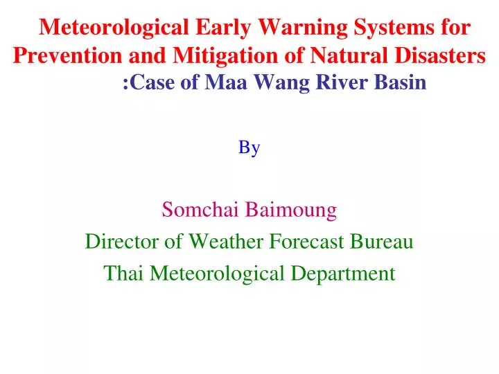
Meteorological Early Warning Systems for Prevention and Mitigation of Natural Disasters:Case of Maa Wang River Basin By Somchai Baimoung Director of Weather Forecast Bureau Thai Meteorological Department
PROBLEMS? • To reduce the possibility of loss of life, personal injury, and damage to property and fragile environments, therefore, meteorological early warning systems in Thailand must be set up (easily and clearly to understand for local people). • Up to now, every related governmental institutions try to establish theirs own early warning system, but the preliminary data must come from TMD. • Natural hazardous always occur in local scale and highly mountainous areas
PROBLEMS? • In this moment, the perfect forecasting system would not be able to deliver precise forecast. • The communication between local people in risky areas with government offices has just begun, not fully successful.
HOW TO SOLVE? • Hopefully, setting up the techniques integration of numerical weather prediction products with remote sensing data and geographic information system may be a necessary appropriate tools nowadays. • These, must be done for developing, manipulating, and also implementing to each appropriate risky area in any regions. • If it is successful, then the gained knowledge and methodology from this site can be a road map for other risky areas of Thailand.
DATA USED & METHODOLOGY Digital Form Digital map of Risky Areas in 1:25,000 1:4,000 NWP Products SatelliteProducts Linear Combination Using GIS Radar Products Telemetering Products In situ Products
DATA USED (in digital form) • NWP Products; - Unified model: Thailand model (17 X 17 km.), Meso scale model (3 X 3 km.) - MM5/WRF: Thailand model (12 X 12 km.) Meso scale model (3 X 3 km.) • Satellite Products; - MT-SAT, NOAA 12-18, MODIS, FY, THEOS • Weather Radar Products - 26 weather radar stations data • Telemetering Products - 1,000 stations (approximate) • In situ Products - Soil data, Land use/Land cover, DEM, Topographical data Slope data, Aspect data, etc
New Unified model Products using GIS Detailed: - Thailand digital map scale 1:250,000 with administration boundaries - Interpolation using “Kriging techniques” with 17 km res. - To be in form of grid cell with 1 km spatial resolution - Using GIS software so-called “Arc view” - Used for any met. parameters
Grid cell format superimposed on Thailand digital map with 1 km spatial resolution for 24 hrs accumulated rainfall
2. MM5&WRF Model Output (Experimental used),which can issue a variety of met. variables for weather forecast every 12 hrs with in 3 days period for instance, MM5 (Res.12 km) WRF (Res.12 km)
EXAMPLES OF SOLUTION MM5/WRF PROJECTION
EXAMPLES OF SOLUTION MM5/WRF DATA LONG, LAT, VAR007 68.9438, 39.4970, 261.6260 69.4474, 39.5502, 276.0664 69.9515, 39.6026, 229.2266 70.4562, 39.6542, 164.4404 70.9613, 39.7051, 105.9023 71.4670, 39.7551, 71.0498 71.9731, 39.8044, 44.2188 72.4798, 39.8529, 64.6318 72.9869, 39.9005, 197.4785 73.4945, 39.9473, 277.1563 74.0026, 39.9934, 275.0801 74.5111, 40.0386, 105.2002 75.0201, 40.0830, -126.6797 75.5296, 40.1265, 23.5176 76.0394, 40.1692, 169.5322 76.5498, 40.2111, 181.0020 77.0605, 40.2522, 113.6992 77.5717, 40.2924, 34.3262 78.0833, 40.3317, -3.3252 78.5953, 40.3702, -70.2490 79.1077, 40.4079, -154.9531 79.6205, 40.4447, -142.7148 80.1337, 40.4806, -125.9580 80.6472, 40.5157, -108.4707 81.1611, 40.5499, -21.8350 81.6754, 40.5832, 107.7773 82.1900, 40.6156, 211.9580 82.7050, 40.6472, 282.4521 83.2203, 40.6779, 311.5059 83.7359, 40.7077, 342.0850 84.2518, 40.7366, 333.2910 84.7681, 40.7646,
New MM5 model Products using GIS Detailed: - Thailand digital map scale 1:250,000 with administration boundaries - Interpolation using “Kriging techniques” with 12 km res. - To be in form of grid cell with 1 km spatial resolution - Using GIS software so-called “Arc view” - Used for any met. parameters
Grid cell format superimposed on Thailand digital map with 1 km spatial resolution for 7-days accumulated rainfall
MTSAT-1R Imageries VIS image IR image
EXAMPLES OF SOLUTION SATELLITE PRODUCTS
R:G:B:2:1:1 NDVI NOAA Imageries
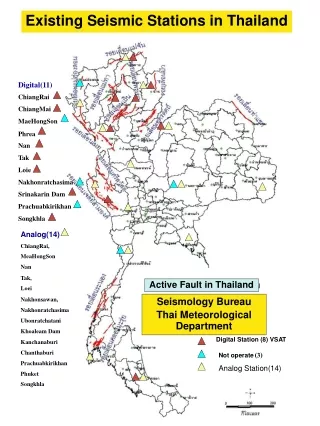
Radar Imageries For these products, which will be consisted of 26 sites such as; Chiang Mai Don Maung, Bangkok
New weather radar imageries with GIS techniques, Chiang Mai site
New weather radar imageries with GIS techniques, Ra Yong site
New weather radar imageries with GIS techniques, Ra Yong site
New weather radar imageries with GIS techniques, Ra Yong site
New weather radar imageries with GIS techniques, Ra Yong site
New weather radar imageries with GIS techniques, Ra Yong site
New weather radar imageries with GIS techniques, Ra Yong site
New weather radar imageries with GIS techniques, Ra Yong site
EXAMPLES OF SOLUTION WEATHER RADAR NETWORK
EXAMPLES OF SOLUTION WEATHER RADAR DATA PhysicalRecordnumberRelativeToBeginnigFile_hw6,VolumeScanNumberRelativeToBeginingTape_hw7,RayNumberWithinVolumeScan_hw8,PhysicalRecordNumberWithinTheRay_hw9,SweepNumberWithinVolumeScan_hw10,SiteName_hw15_18,TimesTampt,Gate,MaxRangeInKilometer,HieghtInKilometer,SlantRangeInKilometer,Latitude,Longitude,DZ,RainRateInMilimeterPerHour 1,1,1,1,1,Chiang M,1.165933809E9,1,240.0,0.012875759150119848,1.0,18.777842825051607,98.9874654710244,36.0,6.484197773255049 1,1,1,1,1,Chiang M,1.165933809E9,2,240.0,0.02586921473084658,2.0,18.772352242482594,98.99160166686356,36.0,6.484197773255049 1,1,1,1,1,Chiang M,1.165933809E9,3,240.0,0.03898036620194034,3.0,18.766861585813746,98.99573758055878,-32768,0 1,1,1,1,1,Chiang M,1.165933809E9,4,240.0,0.052209213017704315,4.0,18.7613708552325,
EXAMPLES OF SOLUTION WEATHER RADAR DIGITAL MAP
Visualization of Radar Image • Presented with Satellite Image (RADROP)
Telemetering Data For these products, which will be covered on 16 river basins and consisted of 1000 automatic stations throughout Thailand such as; River basins and automatic stations of Telemetering Project
EXAMPLES OF SOLUTION TELEMETERING PRODUCTS
EXAMPLES OF SOLUTION IN SI TU PRODUCTS
EXPECTED OUTPUT Digital map of risky areas
Application of Numerical Weather Prediction products for specific purposes - Meteorological Early Warning System; - Flooding areas - Landslide areas - Drought areas estimation etc. - Agricultural weather forecasting; - Crop cultivation areas - Crop yield estimation etc.
Meteorological Early Warning System :Case of Maa Wang River Basin
NORTHERN THAILAND
FLASH FLOOD INUNDATION NORTHERN THAILAND 1994 FLOODS IN NORTHERN THAILAND IN LASTDECADE 2006 2001 2001 1994 1995 2001 1994 1995 2000 2001 2002 1994 1995 2006 2002 2001 2001 2006 1994 1995 2001 2002 2001
Flooding at Mae Wang basin 11 September 2006
Flooding at Mae Wang basin 11 September 2006
Wind Speed & Direction 2.7m Air Temperature & Humidity 2.0m Short & long-wave radiation Rain Fall 1.0m Air pressure in Data logger box -5cm -10cm River Water Level -20cm -40cm : Soil Temperature : Soil Moisture Ground Water Level Site description 1 Mae Wang basin in Chiang Mai (basin area : 600 km2) Instrumentation : Tel-super site NO.1 NO.2 Making well at NO.4 NO.3