Download
1 / 39
390 likes | 531 Vues
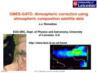
GMES-GATO: Rational Systems for Monitoring regional air quality Paul Monks – University of Leicester Andreas Volz-Thomas – FZ J ü lich. GMES-GATO. Define a strategy for global atmospheric observations to make the best co-ordinated use of existing networks and satellites.

E N D
GMES-GATO: Rational Systems for Monitoring regional air quality Paul Monks – University of Leicester Andreas Volz-Thomas – FZ Jülich
GMES-GATO • Define a strategy for global atmospheric observations to make the best co-ordinated use of existing networks and satellites. • Examine the European monitoring capability (EMC) • Place EMC in a user requirements context • Answer the question – Is there a rational observations system to achieve the necessary measurements, monitoring and modelling to meet the user (policy) requirements? • If not how to achieve within GMES
Issues in respect of atmospheric monitoring • Verification of compliance and success of protocols • Provision of NRT information for public and scientific use • Measurement, quality, archiving and access • Extension of the satellite programme beyond Envisat and MetOp • Development of non-satellite monitoring systems for GMES post-2008 • Provision of funding/ rational funding frameworks
Air Quality AQ is gaseous pollutants and particulate matter from the urban and regional scale to the global scale. AQ on these scales has implications for a number of contemporary issues including: • Human health, (e.g. respiratory, cancer, allergies…), • Eco systems (e.g. crop yields, acidification / eutrophication of natural ecosystems), • National heritage (e.g. buildings), • Regional climate (aerosol and ozone exhibit a strong regionality in climate forcing).
RAQ Outcomes Sources Secondary Route Anthropogenic Aerosol s RO2 CH4, VOC NO CO HO2 OH Oxidants NO, O3 NOx Biogenic Primary Emissions Ozone Hg Heavy Metals POPS
RAQ Outcomes Sources Secondary Route Anthropogenic Aerosol s RO2 CH4, VOC NO CO HO2 OH Oxidants NO, O3 NOx Biogenic Primary Emissions Ozone CO, NO2, VOCs Hg Heavy Metals POPS
RAQ Outcomes Sources Secondary Route Anthropogenic Aerosol s RO2 CH4, VOC NO CO HO2 OH Oxidants NO, O3 NOx Biogenic Primary Emissions Ozone Hg Heavy Metals POPS
RAQ Outcomes Sources Secondary Route Anthropogenic Aerosol s RO2 CH4, VOC NO CO HO2 OH Oxidants NO, O3 NOx Biogenic Primary Emissions Ozone Hg Heavy Metals POPS
RAQ Outcomes Sources Secondary Route Anthropogenic Aerosol s RO2 CH4, VOC NO CO HO2 OH Oxidants NO, O3 NOx Biogenic Primary Emissions Ozone Hg Heavy Metals POPS
Wrong just to think of measurements of chemical or aerosol species … Often policy needs are met through modelling so information needs are subtly different
Information requirements From GMES-BICEPS-AQ-Fiche
Related Policy areas • Policy requirements are more holistic e.g. • Habitats directive • identify pressures and impacts on important habitats from, for example, air pollution
Current Capabilities EMEP – ground based network EARLINET - LIDAR network MOSAIC - in-service aircraft Laboratory measurements Satellite – Science and operational
Overall • Currently, air quality is relatively well-monitored and reported in the EU • a function of its relatively long policy history and well-established monitoring networks (many going back almost 50 years). • But …
Do we have a rational system … Yes and No, but mostly No
What is missing? European monitoring needs substantial improvement in terms of suite of measurements and data quality. The existing networks must be coordinated with other activities and research institutes to build a global network for the monitoring of atmospheric change. • More/better meteorological measurements • More/better precursor measurements • Better understanding of the vertical context • better homogeneity in terms of spatial/temporal coverage of species covered and data quality • Looking towards the future there is also the need to integrate and exploit data.
The grand vision… • European Integrated Monitoring Network for Atmospheric Change • Measurement strategy - Hierarchy of sites • Background sites • Regional master sites • Local Monitoring networks • Aircraft measurements • Satellite measurements
These would reflect key concerns, such as • Establishment of stronger standards for air quality monitoring and reporting, capable of meeting the full range of policy needs • Establishment of more representative monitoring networks, Increased monitoring of key pollutants of environmental or health concern (e.g. fine particulates, benzene, heavy metals). • Asses regions to be monitored (e.g. LRT, UT/LS) • Use of EO data to monitor major pollution events and supplement ground-based networks. • Use of satellite observation to identify and monitor vulnerable habitats, to give early warning about pollution episodes, and to track and attribute pollution events to source.
Requires an integration strategy • Integration of data from satellites/aircraft (interoperability of data) • Data Quality (QA/QC) • Data Basing (Meta-data) • Data assimilation (Usability of data) • Model evaluation and development • NRT delivery • Leading to high-level user products e.g. “Chemical Weather”
What does an end-user want? • Do they want lots of data? • Do they want pretty pictures? • No … • They want to know how effectively their current policies are and their future policies will be.
The Future GMES - Satellite Requirements
ooooooooooo GEO Sampling oooooooooooo ERS-2, ENVISAT METOP Satellites and tropospheric timescales
GeoStationary Observations • The Rationale • Science Drivers – understand the impact of man-made and naturally occurring pollution on the atmosphere. • Political Drivers – Geopolitical requirement for treaty monitoring and compliance (e.g. Kyoto and EU-CLRTAP (Convention on long range transport of air pollutants) • Technological drivers – exploit emerging technologies • Synergy with LEO (Wide swath?)
Geo-Comp Instrument in Geostationary orbit allows continuous viewing of same part of earth Measure absorption of sunlight by various trace-gases in the atmosphere Convert into hemispheric distributions in real time
What is the role for GMES? • The key role of GMES is to provide an integrated data delivery service for users. • GMES should explore the role of a dedicated satellite mission for the delivery of air quality information. • GMES should take sub-national activities and integrate them to achieve a critical mass. • GMES should develop integrated tools for the delivery of AQ information.
Towards a rational system … In the broader sphere, • More interaction between monitoring agencies and the scientific community (quality control, data analysis, model evaluation) • Integration of the existing networks (e.g., national weather services, EMEP, GAW, ESA), including standardisation of the monitoring requirements, data formats, and data provision • Integration of the different existing monitoring systems (ground based networks, aircraft, satellites) • Development of integrated tools for the assessment of AQ on a range of scales • Dissemination of AQ findings and information.
Summary, In Brief • Integration • Assimilation • New instruments and satellites