Download
1 / 15
150 likes | 291 Vues
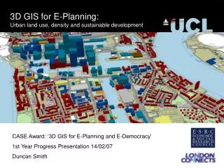
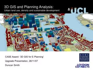
Use GIS-T to Synchronize Land and Infrastructure Development. Principle Investigator: Yingling Fan Humphrey Institute of Public Affairs Co-Investigator: David Levinson and Chen-Fu Liao Department of Civil Engineering. Motivation.

E N D
Use GIS-T to Synchronize Land and Infrastructure Development Principle Investigator: Yingling Fan Humphrey Institute of Public Affairs Co-Investigator: David Levinson and Chen-Fu Liao Department of Civil Engineering
Motivation How do we accommodate growth while maintaining the quality of life for the 2.6 million people who already live and work here?
Twin Cities Reality • Excess capacity: • Resource wasted • Infrastructure deficit: • Economy braked • Quality of life degraded • The tool aims to remove lumps by synchronizing land and infrastructure development, regardless the situation. Infrastructure Excess Capacity Demand Supply Infrastructure Deficit Time
Emerging Needs • Decreased level of transportation funding • Existing infrastructure deficit • Projected regional growth • Needs for land use and transportation integration and optimization • Needs for scenario building & forward planning
Use GIS-T to Synchronize • Data integrity • Predefined GIS operations • Proper topological representation • Spatial analysis/visualization Future of GIS • Knowledge-based GIS • Web-based GIS • GIS integrated with optimization technique • Integrated urban land and transportation planning “Progress in GIS-T has not caught up with the growing spatial data availability.”
LSCMLand Supply and Capacity Monitoring • A perpetual, event-driven system Suitability Analysis Land Supply and Market Database Buildable Land Supply Inventory Estimates of Development Capacity • Land parcels, • Service areas, • Zoning/plan designations, • Government jurisdictions, • Building permits, • Annexations, • Subdivisions, • Sales • Vacant • Partially utilized • Underutilized • Vacant land capacity • Infill capacity • Redevelopment capacity
Land Use KBESKnowledge-based expert system Estimates of Space Requirements Pop/Econ Forecasts Efficient Future Urban Form Estimates of Development Capacity Minimum Travel Growth Scenario Fuzzy Decision Tree
Minimum Travel Approach • Household relocation • Base upon existing and proposed urban form and transportation network Club Gym Children’s School Home Optimum Workplace Shopping Center
Residential Patterns • Observed • Optimum Use expansion weight; N=318,966 households
TINATransportation Infrastructure Needs Assessment • Multi-modal network layers • Traffic counts dataset • Travel time matrices • Travel behavior survey datasets Mobility & Accessibility Evaluation Existing Transportation Networks Report on Infrastructure Deficit Future Urban Form Future Travel Demand Travel Demand Forecasting
Infrastructure SONG/3System of Network Growth Network Growth Modeling Report on Infrastructure Deficit Future Transportation Networks Hypothesized Planning & Policy Contexts • Policy alternatives (e.g., capacity expansion vs. demand management), • budget constraints (e.g., tight vs. loose), • regional priorities (e.g., private transportation-oriented vs. mass transit-oriented), • expansion decision rules (e.g., structured vs. unstructured), • technology perspectives (e.g., ITS-driven vs. conventional options)
The Iterative Loop Control • Converge land & Infrastructure scenarios • Provide multiple optimized solutions • Synchronize land and infrastructure development
Summary of Key Functions • Quantify & evaluate infrastructure needs • Identify locations of transportation improvement • Identify locations of land development • Improve accessibility, quality of life, property values
Summary of Benefits • Ensure a comprehensive set of strategies to be considered • Future-oriented preventative solutions • Protect the integrity of land use and transportation planning