Download
1 / 9
90 likes | 229 Vues
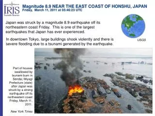
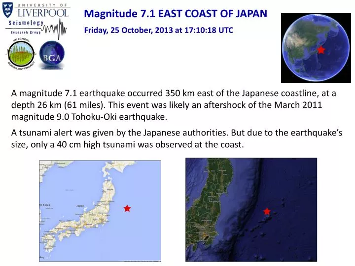
Magnitude 7.1 EAST COAST OF JAPAN. Friday, 25 October, 2013 at 17:10:18 UTC. A magnitude 7.1 earthquake occurred 350 km east of the Japanese coastline, at a depth 26 km (61 miles). This event was likely an aftershock of the March 2011 magnitude 9.0 Tohoku-Oki earthquake.

E N D
Magnitude 7.1 EAST COAST OF JAPAN Friday, 25 October, 2013 at 17:10:18 UTC A magnitude 7.1 earthquake occurred 350 km east of the Japanese coastline, at a depth 26 km (61 miles). This event was likely an aftershock of the March 2011 magnitude 9.0 Tohoku-Oki earthquake. A tsunami alert was given by the Japanese authorities. But due to the earthquake’s size, only a 40 cm high tsunami was observed at the coast.
Magnitude 7.1 EAST COAST OF JAPAN Friday, 25 October, 2013 at 17:10:18 UTC Since the earthquake occurred around 350 km from the coastline of Japan, no strong shaking was felt. Shaking intensity
Magnitude 7.1 EAST COAST OF JAPAN Friday, 25 October, 2013 at 17:10:18 UTC USGS PAGER alert Population Exposed to Earthquake Shaking Overall, the population in this region resides in structures that are resistant to earthquake shaking, though some vulnerable structures exist. Recent earthquakes in this area have caused secondary hazards such as tsunamis, landslides, and fires that might have contributed to losses. Green alert level for shaking-related fatalities. Green alert level for economic losses. There is a low likelihood of casualties and damage. Images courtesy of the US Geological Survey
150 km Magnitude 7.1 EAST COAST OF JAPAN Friday, 25 October, 2013 at 17:10:18 UTC Earthquake and historic seismicity The earthquake epicentre (purple dot) is plotted on the map with regional seismicity greater than M6.5 since 1973. This includes aftershocks from the great March 2011 earthquake. Subduction zones at the Japanese island arcs are geologically complex due to its location at the intersection of four major tectonic plates. The region within 300 km of the October 25 earthquake has hosted more than 40 events of M6.5 or greater. The March 2011 Tohoku earthquake is the largest one with M9.0. Since then, two large events of M7.7 and M7.3 have occurred in the vicinity of the October 25 earthquake. The M7.7 event, on March 11, 2011, was also a normal faulting event occurred 95 km north of the October 25 event. The M7.3 event, on December 7, 2012, was a more complex earthquake resulting from thrust motion near the trench 100 km to the northwest of the October 25 earthquake.
North America Plate Eurasia Plate 83 mm/yr Pacific Plate Philippine Sea Plate M7.1 - Off the east coast of Honshu, Japan Friday, October 25 2013 17:10:18 UTC Tectonic summary The earthquake occurred as the result of normal faulting in the shallow oceanic crust of the Pacific plate. The Pacific plate moves westwards with respect to the North America plate at a rate of 83 mm/yr before subducting beneath the island of Honshu. The figure on the left shows the style of faulting (focal mechanism), and the right one shows schematically how blocks associated with the normal faulting move.
Magnitude 7.1 EAST COAST OF JAPAN Friday, 25 October, 2013 at 17:10:18 UTC Aftershock seismicity So far, 8 aftershocks have been recorded by the USGS. The largest of these was a magnitude 5.5 earthquake, 4 hours after the mainshock. Most aftershocks appear to have occurred directly to the north and to the south of the mainshock epicentre (large orange circle).
Magnitude 7.1 EAST COAST OF JAPAN Friday, 25 October, 2013 at 17:10:18 UTC Seismogram recordings by the BGS seismometer network First body wave arrivals Surface waves Time of earthquake It took just 11 minutes for the first seismic waves to arrive in the UK! See http://www.iris.edu/hq/files/programs/education_and_outreach/aotm/12/Traveltime_background.pdf for an explanation of these seismic phases
Magnitude 7.1 EAST COAST OF JAPAN Friday, 25 October, 2013 at 17:10:18 UTC Seismogram recordings by the UK school seismometer network Surface waves DEOS, University of Liverpool STED (St. Edwards School, Poole Time of earthquake See http://www.iris.edu/hq/files/programs/education_and_outreach/aotm/12/Traveltime_background.pdf for an explanation of these seismic phases
Magnitude 7.1 EAST COAST OF JAPAN Friday, 25 October, 2013 at 17:10:18 UTC Find out more…. • BGS (British Geological Survey) – seismology and earthquakes – frequently asked questions http://www.earthquakes.bgs.ac.uk/education/faqs/faq_index.html • IRIS (Incorporated Research Institutions for Seismology) – learning about earthquakes http://www.iris.edu/hq/programs/education_and_outreach/students • UK School Seismology Project – classroom activities, videos and support documents http://www.bgs.ac.uk/schoolseismology/home.html • USGS (United States Geological Survey) – FAQs, glossary, posters, animations http://earthquake.usgs.gov/learn/ • USGS summary of the Japan earthquakehttp://earthquake.usgs.gov/earthquakes/eventpage/usc000kn4n#summary • BBC News report and video from 25th October 2013 • http://www.bbc.co.uk/news/world-asia-24677578