Download
1 / 11
110 likes | 210 Vues
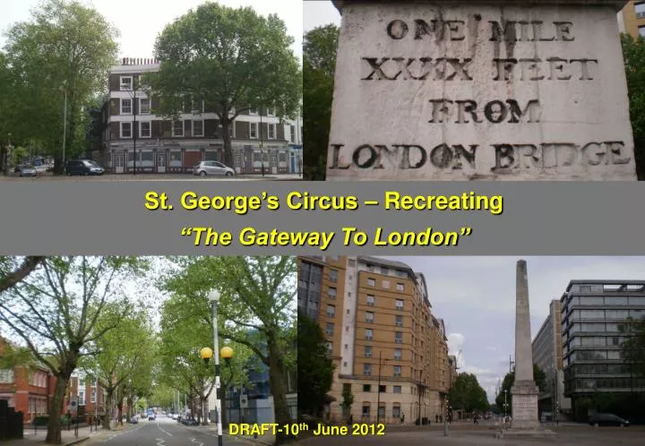
St. George’s Circus – Recreating “The Gateway To London”. DRAFT-10 th June 2012. Introduction.

E N D
St. George’s Circus – Recreating “The Gateway To London” DRAFT-10th June 2012
Introduction. • St George’s Circus in Southwark is one of the junctions on the Transport for London Road Network which is included in the programme of Junction Reviews by Transport for London in the wake of the deaths of two cyclists at Bow in late 2011. These reviews are focussed primarily on safety of cyclists and (increasingly) pedestrians. As St George’s Circus is an historic location there is also interest in improving the public realm there. • A group of people from Living Streets, London Cycling Campaign, CTC, RoadPeace and local residents met there on May 15 2012 to consider opportunities for improvements. This paper reviews their findings. • Report prepared by the following groups: • Susie Morrow, Caroline Russell and Tom Platt, Living Streets • Oliver Schick and Alastair Hanton, London Cycling Campaign • Jeremy Leach and Clare Armstrong, Southwark Living Streets • Alex Crawford, Southwark Cyclists • Peter Wood, The Open University • Roger Geffen CTC • David Dansky, RoadPeace • Richard Reynolds, Guerrilla Gardener The sole access point to the historic obelisk and “Gateway to London” is from a single narrow entrance to the south of the space.
History. • St George’s Circus was built in 1771 to provide a fitting entrance to London from the south, with roads radiating to all the Thames bridges between London Bridge and Lambeth Bridge. • The Circus contains an obelisk with the inscription “Erected in XI year of the reign of King George MDCCLXXI” • Queen Victoria’s jubilee procession passed through the circus in 1897. • Since 2005 part of the central area has been planted and tended by voluntary guerrilla gardeners with lavender, rosemary, tulips, campanula and azaleas. Impact of recent planting One of the inscriptions
Traffic Function. • The roads around the Circus are part of the gyratory traffic system of London Road, St George’s Road and Lambeth Road, with connections to Westminster Bridge Road, Waterloo Road, Blackfriars Road and Borough Road. • Bus routes 1, 12, 45, 53, 63, 68, 100, 148, 155, 168, 171, 172, 176, 188, 344, 360, 363, 453, 468 and C10 pass through the Circus. • The Circus is also well used by cyclists going to and from the Thames bridges, the nearby London South Bank University and elsewhere. • The Circus is on pedestrians’ routes, notably between the University and McLaren House, a residence for 600 students on the northwest side of the Circus. Carriageway capacity A pedestrian crossing from McLaren House
Current developments in the neighbourhood. • The South Bank University Estates Development plan includes bringing into use the currently unused buildings on the eastern side of London Road. This will add to the presently unsatisfied pedestrians’ demands on the Circus. • Planning consent has been granted for the redevelopment of the large building (Erlang House) and vacant space to the north east of the Circus. • Several substantial office and other buildings are being planned for Blackfriars Road. These are at various stages of development. • To the south, major redevelopment of the Elephant and Castle area is in hand, incorporating new housing, a new leisure complex, rejuvenation of the shopping centre and some changes to the road layout. New hotel development Historic buildings being brought back into use by LSBU Erlang House & adjacent development site
St George’s Circus as a public space. • The vision of the original designers of St George’s Circus was for a fitting “Gateway”, situated by reference to other London landmarks, including the river Thames, a short distance to the north. This vision has been lost in the concentration on the function of the junction as primarily serving motor traffic. The result is a public space almost devoid of people and an obelisk lacking function and context. Because of the traffic and the ramped edges all round, the only access for pedestrians is from London Road in the south. Ramped edges. Short walk to Southwark Tube Station, the Palestra building, The Cut & the river.
Walking and Cycling. • Both these modes suffer from the all-pervasive effects of domination by motor traffic, including noise, air pollution, danger and intimidation. • A better ambience for walking and cycling would improve the commercial as well as civic quality of the area, encouraging local journeys on foot and by cycle instead of clogging up public transport for short journeys. The redevelopment of Blackfriars railway station, with now a third of passengers using the entrance/exit on the south bank, will alter the mix of uses and journeys in the area. • Measures to enhance walking and cycling should be seen in the light of the publication for consultation in April 2012 of draft Guidance on Walking and Cycling by the National Institute for Health and Clinical Excellence (NICE). Pedestrian crossings set well away from desire lines. Staggered crossings ensure pedestrians cannot cross in one movement and encourage risk taking.
Walking. • Walking’s function as a means of enjoying the place is largely absent from St George’s Circus. Even the enjoyment of the guerrilla garden on the northwest quadrant of the Circus is frustrated by the noise and other effects of traffic. Similarly, appreciation of the historic obelisk is blunted. • The main problem for walking is the absence of safe routes across the Circus. A principal desire line is southeast/northwest, notably between McLaren House and the university. The student residents are forced to climb the ramps encircling the central space and jump onto the carriageway during gaps in the traffic from the adjacent traffic signals. • St George’s Circus is a barrier to pedestrian movement to and from both the Thames to the north and the Elephant and Castle to the south. As an illustration, we compared the time to walk from the Subway café on the southern side to the mouth of Blackfriars Road on the north. The “official” route, via zebras in Westminster Bridge Road, took over 3 minutes; the more dangerous route via the zebra in London Road took just 40 seconds. • Even the existing facilities for walking are unsatisfactory. Following rain, the 'ponding' at the zebra crossing across London Road forces pedestrians to jump onto the zebra or encourages them to take a dangerous short cut. Wayfinding information for pedestrians is completely absent. The route (in red) that pedestrians are expected to take (3minutes +) compared to the desire line (black – 40 seconds). The route pedestrians want to take. http://www.openstreetmap.org
Cycling • Cars, lorries and buses circle like sharks. Only really confident cyclists can cope with the traffic swinging from lane to lane. • Some important cyclists’ routes cannot be achieved, e.g. from Borough Road westwards to Waterloo Road. High vehicle speeds in free flowing traffic and lack of clarity as to lanes add to cyclist danger. Important westerly cycle route on Borough Rd cannot be continued owing to St George’s Circus gyratory.
What should be done? • It is apparent from the preceding notes that a major reappraisal of St George’s Circus is needed. This should include: • Options for access and crossing the central area. • Blackfriars Road, wide enough to be a fine boulevard, northwards and the tree lined Borough Road eastwards. • The effect of the gyratory to the south and west. • The alternatives of (a) retaining the central island, making it accessible to pedestrians; or (b) recreating a central crossroads, with the public realm space provided by the freed-up space on the four quadrants of the Circus. • In the absence of such an appraisal one can pick out a few possible measures from the issues highlighted during our visit. These measures might include: • Reducing carriageway widths, to restrain traffic speeds and help pedestrians crossing to the central space. • Reducing the number of lanes on the eastern side, with overrun areas borrowed from the central space to provide resilience for emergencies. • Measures to satisfy the apparent desire line for pedestrians (SE/NW) such as a zebra crossing outside McLaren House. • Tightening the splays and narrowing the mouths of Borough Road and other roads to reduce vehicle speeds and help pedestrians cross. • Limiting speeds to 20 mph to make cycling safer and bring more calm to the location. • Simple measures such as wayfinding, seating and repair of the obelisk.
Conclusion • The TfL junction review is welcome. The special historic and location characteristics of St George’s Circus call for its review to be widened to include place making. • We hope that the following bodies can collaborate on a widened review: • Transport for London. • London Borough of Southwark. • London South Bank University. • English Heritage. • Organisations participating in this visit. • Trafalgar Square, Buckingham Palace and Exhibition Road are outstanding examples of other places in London which were previously dominated by traffic where the public realm has in recent years been transformed for the better. • This report is being sent to senior officials in each of these bodies.