Download
1 / 28
290 likes | 494 Vues
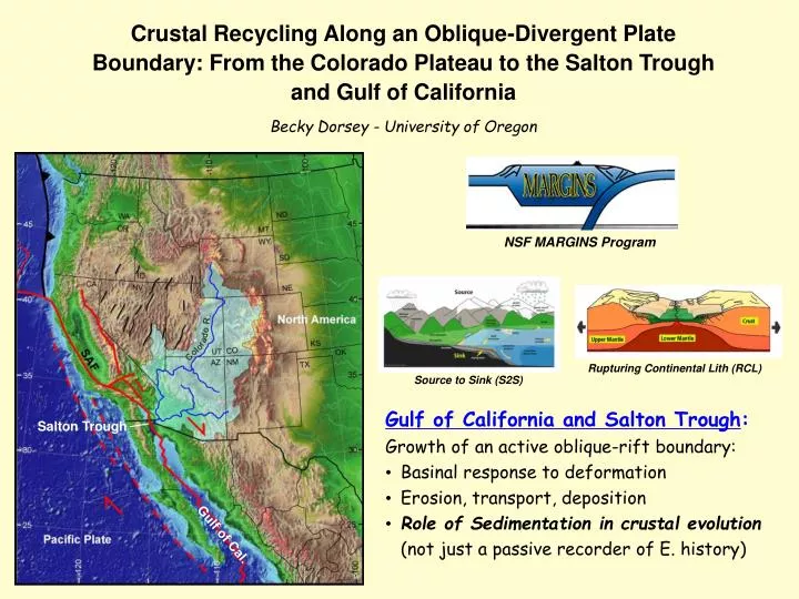
NSF MARGINS Program. Crustal Recycling Along an Oblique-Divergent Plate Boundary: From the Colorado Plateau to the Salton Trough and Gulf of California Becky Dorsey - University of Oregon. Rupturing Continental Lith (RCL). Source to Sink (S2S). Gulf of California and Salton Trough :

E N D
NSF MARGINS Program Crustal Recycling Along an Oblique-Divergent Plate Boundary: From the Colorado Plateau to the Salton Trough and Gulf of California Becky Dorsey - University of Oregon Rupturing Continental Lith (RCL) Source to Sink (S2S) • Gulf of California and Salton Trough: • Growth of an active oblique-rift boundary: • Basinal response to deformation • Erosion, transport, deposition • Role of Sedimentation in crustal evolution(not just a passive recorder of E. history) Salton Trough Gulf of Cal.
COLLABORATORS Gary Axen (N.M. Tech) Amy Spears (WWU) Susanne Janecke (Utah State Univ.) Bernie Housen (WWU) Mike Oskin (U.C. Davis) Molly Keogh (U. Oregon) Tom Peryam (U. Oregon) Kim Le (U.C. Davs)
Rift Architecture:sediment load promotes early transition to narrow rift mode (Bialas and Buck, 2009). Bialas and Buck (2009) Extension with Sedimentation Extension without Sedimentation Sediments are one of the main recorders of tectonic events, but they may also affect the way compression or extension proceeds. It is now accepted that the unloading effect of erosion can change the pattern of compressional deformation in areas of continental convergence … In a similar way, we suggest that the load of sediments may promote localized deformation in areas of continental extension (Bialas and Buck, 2009). Sediment Wide Rift Mode Narrow Rift Mode The weight of sediments reduces the difference in crustal buoyancy forces between adjacent blocks, allowing strain to localize. Influence of Sediments on Crustal Architecture and Evolution • Build Transitional Crust (O.C.T.)at rifted margins (Fuis et al., 1984; Nicolas, 1985; Wu et al., 2006) • Thermal Effect of thick sediment: -Warm the lithosphere due to insulation (Lizzaradle et al., 2007) ? -Cool the lithosphere due to addition of cold seds ? Nova Scotia margin (Wu et al., 2006)
Today’s Talk: * Brief Overview of Gulf-Trough Region Exposed Late Cenozoic Section, Western Salton Trough:+ Initiation (?) and growth of Pacific - North Am. plate boundary+ First arrival of Colorado River sediment in tectonic lowland+ Colorado River delta progradation and basin filling Regional Sediment Budget, Mass Balance:+ Estimate volume of sediment in subsurface basins+ Compare to volume eroded from Colorado Plateau+ Explore implications for crustal growth and recycling Gulf of California and Salton Trough
~ 120 km E-W extension in B&R ~ 16 to 10 Ma (Wernicke and Snow, 1998; Fitzgerald et al., 2009; Colgan and Henry, 2009). Inversion of Topography … prob. low by about 8-10 Ma. ? remnant topography Colorado River drainage integrated at 6 Ma. (Spencer et al., 2001; House et al., 2005), Entered Salton Trough ~5.3 Ma (Dorsey et al., 2007) Colorado R. Colorado R. 20 Ma 36 Ma 6 Ma 0 Ma 10 Ma McQuarrie and Wernicke (2005)
TWO CONTRASTING MODELS for kinematic evolution of the Pac. - North America plate boundary: 12 to 6 Ma. 12.3 to 6 Ma 12.3 Ma 6 to 0 Ma Baja Calif. 1. Regional Strain PartitioningStock and Hodges (1989)Oskin and Stock (2003) Late Miocene 2. Regional Integrated StrainGans (1997), Fletcher et al. (2007) 12.3 - 6 Ma 6 to 0 Ma 12.3 Ma Models agree on past 6 m.y. Baja Calif. Fletcher et al. (2007) GSAB
Northern Gulf • Water depth: ≤200 m • Sed Thickness: 8-12 km accum. in past 6-8 Myr. • Total Crust: 15-20 km • No true Ocean Crust past 5-6 Myr • Central Gulf • Water depth: ~1,600 m • Sed Thickness ~3 km • Total Crust: 9-10 km • Ocean Crust since ~3 Ma • Southern Gulf • Water depth: ~2,500 m • Sed Thickness ~1 km • Total Crust: ~6 km • Ocean Crust since ~3 Ma Lizarralde et al. (2007), and others Basins of the Gulf of California & Salton Trough Dorsey and Umhoefer (in press)
scec M 7.2 Earthquake (April 4, 2010) 1. Late Cenozoic Basin Development, Western Salton Trough Southern San Andreas Fault System
Fish Creek - Vallecito Basin mod. from Winker (1987); Axen and Fletcher (1998)
Earliest Marine Turbidites (6.3 Ma) WSDF Large Rock Avalanche Alluvial-Fan Conglomerate Active Rift Basin, Steep Local Topography Fish Creek - Vallecito Basin, western Salton Trough Top of Sxn ~0.95 Ma 2.65 and 2.60 Ma Base of Marine ~ 6.3 Ma Base of Sxn ~ 8.0 ± 0.4 Ma
Initiation of paleo-San Andreas fault at ~7-8 Ma? 7-8 Ma Present Day
A. Diablo Fm., Palm Spring Gp. Top of Sxn ~0.95 Ma 2.65 and 2.60 Ma marine turbidites, Latrania Fm. Oldest Col. R. sand = 5.3 Ma Locally - Derived
Sand Composition chert Subsurface Herzig et al. (1988) volc. C-suite mixed- source L-suite qtz qtz metam. Colorado River - Derived Outcrop biotite plag. Locally - Derived
~ 4 Ma Delta Progradedduring abrupt increase in subsidence rate, fluvial conditions persisted during rapid subsidence. Requires large increase in sediment flux rate. Seen in other supply-driven delta systems(Goodbred and Kuehl, 2000; Carvajal and Steel, 2006) Colorado Delta Progradation Continuous Fluvial Top of Sxn ~0.95 Ma 2.65 and 2.60 Ma Base of Sxn ~ 8.0 ± 0.4 Ma
Colorado R. Axen (2008) Linked slip on southern SAF and west Salton detachment fault. Space created by lithospheric rupture is filled with basaltic intrusions from below and voluminous sediment input from above (mainly Colorado River).
satellite view looking SE along the Pac-NAM plate boundary, GoC and S.T. NASA 2. Regional Sediment Budget, Mass Balance Rapid Sediment Input to active oblique-rift basins during past 5-6 Myr. Sediment builds new (recycled) crust as it is buried and metamorphosed ... Regional-scale crustal recycling system. Calif. North America Gulf of Pacific Plate • Next: • Calculate Volume of sediment in basins • Rate of crustal growth • Implications for rift-margin evolution Trough Colorado R. Salton
SOURCE: Colorado River Catchment Area: 630,000 km2 4th largest in conterminous U.S.;~10-15 times the area of the sink. Dissolved Load (TDS): ~ 400 ppm (early 1900’s) ~ 800 ppm (modern) Sediment Discharge: 1.2-1.5 x 10⁸ t/yr (pre-dam)~ 1.0 x 10⁵ t/yr (modern)(Meade and Parker, 1985) SINK: Basins in Salton Trough and northern Gulf of California • Opened by oblique divergence along plate boundary since ~6-8 Ma. • Colorado River sediment arrived in Salton Trough at ~5.3 Ma ... • has dominated basin fill since then. • Rapid subsidence and sediment accumulation (~2-3 mm/yr) • High heat flow: greenschist facies metam. (~300°) at 2-4 km depth.
Estimate VOLUME of Colorado River - derived sediment in subsurface basins …
Estimate VOLUME of Colorado River - derived sediment in subsurface basins … DATA: recent seismic studies, information about basin depth and crustal structure.
Estimate VOLUME of Colorado River - derived sediment in subsurface basins … DATA: recent seismic studies, information about basin depth and crustal structure. AREA of 6 main depocenters; multiply by depth … • UNCERTAINTIES: • total basin depth (requires crustal model) • sed. composition and age • volume of intrusions at depth
Shallower, unmetamorphosed basins: well imaged in sesimic-reflection studies Altar Basin Pacheco et al. (2006) Tiburon Basin Aragon & Martin (2007)
For deeper basins, use crustal model of Fuis et al. (1984) – Salton Trough: Lithosphere is fully ruptured: Unmetamorphosed seds are 4-5 km deep; Basement = [metaseds + mafic intrusions] 0 Salton Trough sediments metaseds + intrusions 10 12 km 20 basaaltic crust 30 Fuis and Mooney (1991) 40 … explains seismic refraction data, velocity structure 0 Increasing seismic velocity (Vp) is typical of sedimentary basin fill. 10-12 km in 5.3 m.y. requires accum. rate of 1.9-2.3 mm/yr … consistent with measured rates (Van Andel, 1964; Herzig et al., 1988; Dorsey et al., in press). unmetamorphosed basinal sediments 4-5 (gradual transition) Average Vp (5.65 km/s) is too slow for old crystalline rock (5.9-6.0 km/s). Consistent w/ metaseds & intrusions. meta-sedimentary rock and intrusions 10-12 (abrupt increase in Vp) Faster velocities (7.5-8.0 km/s) could be basaltic crust (Fuis et al., 1984) or partially serp. mantle (Nicolas, 1985). “sub-basement” = basaltic crust or partially serpentin. mantle Depth (km) Fuis et al., (1984) 20
For deeper basins, use crustal model of Fuis et al. (1984) – Salton Trough: Lithosphere is fully ruptured: Unmetamorphosed seds are 4-5 km deep; Basement = [metaseds + mafic intrusions] 0 Salton Trough sediments metaseds + intrusions 10 12 km 20 basaaltic crust 30 Fuis and Mooney (1991) 40 Northern Gulf of California Delfin Basin Tiburon Basin sediments sediments 5 km metasedim. rx + intrusions 10 km lower crust Gonzalez et al. (2005)
BRACKET VARIABLE PARAMETERS: Salton Trough Northern Gulf Depth to base of unmetamorphosed sediments 4-5 km 4-5 km Depth to base of metased. rocks and intrusions 10-12 km 8-10 km Volume % of intrusions in metasedim. rocks 10-40% 10-40% Thickness of non-C.R. seds at base of section 100-1000 m 100-1000 m Depth x Area: min. and max. volumes for the 6 basinal domains … RESULT: Total volume of Colorado R. sediment in subsurface basins is ~ 2.2 - 3.4 x 10⁵ km3
Compare to volume of rock eroded from Colorado River catchment (two estimates): (1)Spatially averaged erosion on Plateau (Pederson et al., 2002), corrected for ratio of pre- to post-6 Ma erosion (Flowers et al., 2008), plus modest inputs from the Virgin and Gila rivers: ~ 2.0 x 10⁵ km3. (2)Multiply pre-dam sediment discharge (1.2-1.5 x 10⁸ t/yr; Meade and Parker, 1985) by time since first arrival of C.R. sand in the Salton Trough (5.3 Ma), and simple density conversion: 2.5-3.1 x 10⁵ km3. * Preliminary, needs more work * Volume of sediment stored in plate-boundary basins (~ 2.2 - 3.4 x 10⁵ km3) is roughly equal to volume of rock eroded from Colorado R. in past 5-6 m.y.
Rate of Crustal Growth: 1. Input of sediment to plate-boundary basins = volume / time / distance along strike = 2.2 - 3.4 x 10⁵ km3 / 5.3 m.y. / 500 km along strike = ~ 80 - 130 km3 / m.y. / km 2. Magmatic accretion at seafloor spreading centers: = 50 - 160 km3 / m.y. / km (slow and v. slow spreading rates) = 250 - 800 km3 / m.y. / km (medium to fast spreading rates) 3. Magmatic accretion at island arcs: = 25 - 67 km3 / m.y. / km (Philippines) = 30 - 95 km3 / m.y. / km (other west Pacific arcs) = 80 - 200 km3 / m.y. / km (Izu-Bonin arc)
sediments metaseds + intrusions basaaltic crust Fuis and Mooney (1991) Salton Trough and Northern Gulf of California Insights into crustal evolution and structure at ancient rifted margins. Nova Scotia margin (Wu et al., 2006) • “Novel type of crust”: rifting and basin filling (Moore, 1973; Fuis et al., 1984; Nicolas, 1985). • Surface Processes: Important mechanism of crustal growth and recycling … similar in scale and rate to magmatic accretion at subduction zones and slow spreading centers. • May be important at other rift and oblique-rift margins where large continental drainage is captured following tectonic collapse and subsidence of a pre-existing orogenic highland.