Download
1 / 20
200 likes | 347 Vues
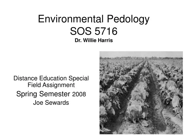
Environmental Pedology SOS 5716 Dr. Willie Harris. Distance Education Special Field Assignment Spring Semester 2008 Joe Sewards. Objectives. Obtain experience and feedback in soil description and interpretation

E N D
Environmental PedologySOS 5716Dr. Willie Harris Distance Education Special Field Assignment Spring Semester 2008 Joe Sewards
Objectives • Obtain experience and feedback in soil description and interpretation • Observe how two soils differ based on soil forming factors and genetic processes • Share interpretations of the soils
Soils of the Hastings, Florida Area • Background • Hastings, Florida is known as the “Potato Capital” of Florida • It is a highly agricultural area where potatoes, sweet sorghum, cabbage and sod are the primary crops.
Geographic Characteristics • Hastings is on the border of St. Johns and Putnam Counties. • It averages seven feet above mean sea level. • Deep Creek is a tributary of the St. Johns River, is about 2 miles northeast of Hastings and is tidally influenced.
Where Soil Descriptions are Located • FPWACS – The Florida Partnership for Water, Agriculture and Community Sustainability at Hastings. • Formerly a U.F. research facility dedicated to potato research. • Now a U.F. demonstration and research facility dedicated to low-impact development and alternative agriculture Area of Project On General Soil Map
Index to Detailed Map Sheets • The average elevation at the FPWACS site is four feet above mean sea level. • Drainage ditches that are, at times, dry have been observed to spontaneously fill with water during high tides. Hastings
Deep Creek Area of project State Road 207 Town of Hastings
Soil 1 Soil 2 U.F.FPWACS
Description of Soil 1 • From the St. Johns County Soil Survey: • Wabasso fine sand (soil type 21) • Poorly drained, nearly level, slope 0 to 2 percent • Surface layer - black, fine sand, upper 4 inches • Very dark gray fine sand in lower 2 inches • Subsurface layer is light gray, fine sand to about 25 inches • Lower part of subsoil is about 13 inches thick; upper 8 inches is brown fine sandy loam; next 5 inches is grayish brown sandy clay loam
Observations and Evaluations of Soil 1 “Ap” horizon – 25-30 cm Texture – Sandy Color – Gleyed 2, 2.5, 5B Boundary – Clear, abrupt Structure – Weak Infiltration - High “E” horizon – 12-15 cm Texture – Sandy Color – Gleyed 2, 6, 5B Boundary – Gradual, diffuse Structure – Moderate Infiltration - Moderate “Bt” horizon – 25 cm Texture – Sandy Color – Gleyed 2, 8, 10B Boundary – Gradual, diffuse Structure – Moderate Infiltration - Moderate Redox present “Btg” horizon – 12-25 cm Texture – Sandy clay Color – Gleyed 2, Boundary - Diffuse Structure – Moderate Infiltration - Low Redox present
Another view of Soil 1 “Ap” “E” All Sandy texture “Bt” “Btg” Sandy clay
Soil 1 – “Ap” Horizon • Sandy texture • Weak structure • Cannot form a ribbon
Soil 1 – “Btg” horizon • Sandy clay texture • Gleyed color with redox • Can easily form a ribbon
Soil 1 Classification • Epipedon- Umbric • Subsurface horizon – Argillic • Soil order – Alfisol Soil 1 Properties Pit for Soil 1 filling with water • Infiltration - High • Hydraulic conductivity – High (sandy texture) • Available water - High • Soil wetness class - 5 • Limitations • Dwelling w/basements - severe • Septic tanks - severe • Local roads and streets - poor Soil 1 Site Characteristics • Position – Stream terrace • Parent material – Marine • Soil slope – Nearly level, 0 to 2% • Surface runoff – Ponded to very slow • Erosion potential – Very low
Description of Soil 2 Excerpts from the St. Johns County Soil Survey Floridana Fine Sand • Poorly drained, nearly level, slope 0 to 2 percent • Surface layer is black, fine sand about 11” thick • Seasonal high water table within 10” for 4 – 6 months • Natural vegetation: slash pine, cabbage palm, water oak, etc. Most areas cleared and used for cabbage and potato production. • … severely limited due to wetness.
Soil 2 “Ap” horizon – 25-30 cm Texture – Sandy Color – 7.5YR, 5, 2 Boundary – Clear, abrupt Structure – Weak Infiltration - High “Eg” horizon – 15 cm thick Texture – Sandy Color – 7.5YR, 6, 1 Boundary – Wavy, diffuse Structure – Moderate Infiltration -Moderate “Bh” horizon – 10-20 cm thick Texture – Sandy Color – 7.5YR, 4, 2 Boundary – Gradual, wavy Structure – Moderate Infiltration - Moderate “Btg” horizon –15-30 cm thick Texture – Sandy clay Color – Gleyed 2, 8, 10B Boundary – Diffuse, wavy Structure – Moderate (strong ribbon) Infiltration –Slow Redox concentrations present
Another View of Soil 2 • Ap horizon • E horizon • Bh horizon • Btg horizon
Soil 2 Classification • Epipedon- Umbric • Subsurface horizon – Argillic • Soil order – Alfisol Soil 2 Properties • Infiltration - High • Hydraulic conductivity – High (sandy texture) • Available water - High • Soil wetness class - 4 • Limitations • Dwelling w/basements - severe • Septic tanks - severe • Local roads and streets - severe Floridana Fine Sand Soil 2 Site Characteristics • Position – Flood plain • Parent material – Marine • Soil slope – Nearly level, 0 to 2% • Surface runoff – Ponded to very slow • Erosion potential – Very low