Download
1 / 146
1.46k likes | 1.53k Vues
In the rapidly growing cities of the developing world, the areas where the poorest migrants from rural areas tend to settle are in slums surrounding the central city. in squatter settlements on the outskirts of the city. in the commercial sector.

E N D
In the rapidly growing cities of the developing world, the areas where the poorest migrants from rural areas tend to settle are • in slums surrounding the central city. • in squatter settlements on the outskirts of the city. • in the commercial sector. • adjacent to shopping malls and discount outlets • near places of employment.
In the rapidly growing cities of the developing world, the areas where the poorest migrants from rural areas tend to settle are • in slums surrounding the central city. • in squatter settlements on the outskirts of the city. • in the commercial sector. • adjacent to shopping malls and discount outlets • near places of employment.
2. When people identify the “old neighborhood” as the place where they grew up, which of these kinds of geographic features are they primarily identifying? • Geologic • Systematic • Agrarian • Physical • cultural
2. When people identify the “old neighborhood” as the place where they grew up, which of these kinds of geographic features are they primarily identifying? • Geologic • Systematic • Agrarian • Physical • cultural
3. A forward city is a city strategically placed by a national government to identify some aspect of a country’s goal for either internal development or for establishing a position of importance in the international community. Which of these cities best represents a forward capital in modern world? • Beijing • Brasilia • Washington, D.C. • Cairo • Berlin
3. A forward city is a city strategically placed by a national government to identify some aspect of a country’s goal for either internal development or for establishing a position of importance in the international community. Which of these cities best represents a forward capital in modern world? • Beijing • Brasilia • Washington, D.C. • Cairo • Berlin
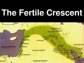
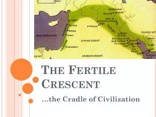
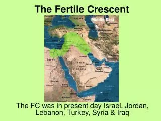
4. The most common geographic synonym for the Middle East is • Fertile Crescent • North Africa • Trans-Caucasus • Southwest Asia • East Asia
4. The most common geographic synonym for the Middle East is • Fertile Crescent • North Africa • Trans-Caucasus • Southwest Asia • East Asia
Which of these was a pull factor that encouraged poor European migrants to settle in the United States in the late 19thcentury? • compulsory military duty for males • civil rights • job opportunities in factories and on farms • use of English as a primary language in public schools • the promise of citizenship for joining the army
Which of these was a pull factor that encouraged poor European migrants to settle in the United States in the late 19thcentury? • compulsory military duty for males • civil rights • job opportunities in factories and on farms • use of English as a primary language in public schools • the promise of citizenship for joining the army
What has the Green Revolution accomplished since it was implemented in the 1960s? • It has brought an understanding that the world’s tropical rainforests are endangered. • It has freed the developing countries in Africa from fear of a food shortage. • It has called attention to the effect of acid rain on forests in industrial regions. • It has greatly increased yields of basic food crops in some developing countries. • It has marked the end of such tropical diseases such as malaria.
What has the Green Revolution accomplished since it was implemented in the 1960s? • It has brought an understanding that the world’s tropical rainforests are endangered. • It has freed the developing countries in Africa from fear of a food shortage. • It has called attention to the effect of acid rain on forests in industrial regions. • It has greatly increased yields of basic food crops in some developing countries. • It has marked the end of such tropical diseases such as malaria.
Which of the following is the best example of a geographic transition zone? A. The Sahel B. Great Lakes region C. Nile River D. Appalachian Mountains E. San Andreas Fault.
Which of the following is the best example of a geographic transition zone? A. The Sahel B. Great Lakes region C. Nile River D. Appalachian Mountains E. San Andreas Fault.
Which of the following is an example of sequent occupance? • Mount Everest • South African veld • Indonesian rainforest • Montana cattle ranch • North Atlantic Drift
Which of the following is an example of sequent occupance? • Mount Everest • South African veld • Indonesian rainforest • Montana cattle ranch • North Atlantic Drift
9. In which of these ways did the principle of intervening opportunity affect migration to Australia in the early days of settlement on that continent? • Information about Australia flowing back to Britain was blocked by the Pacific Ocean. • European cultural influences were slow to reach Australia. • Many British emigrants settled in colonies closer to England rather than travel the great distances to Australia. • People in England perceived Australia to be so hostile an environment that colonization would never be successful. • The Australian aborigines made settlement difficult in the interior of the country.
9. In which of these ways did the principle of intervening opportunity affect migration to Australia in the early days of settlement on that continent? • Information about Australia flowing back to Britain was blocked by the Pacific Ocean. • European cultural influences were slow to reach Australia. • Many British emigrants settled in colonies closer to England rather than travel the great distances to Australia. • People in England perceived Australia to be so hostile an environment that colonization would never be successful. • The Australian aborigines made settlement difficult in the interior of the country.
10. Austin, Texas, has become a center for the manufacturing of computers. What major change has most likely resulted in the economy of the city and its region? • The state government has had to relocate. • Fewer minimum wage jobs are available than a few years ago. • Most of the citizens of Austin have been unaffected by this change in basic industry. • The quality of life has diminished because of the influx of new workers. • There has been a building boom because of the demand for housing for all of the new workers and their families.
10. Austin, Texas, has become a center for the manufacturing of computers. What major change has most likely resulted in the economy of the city and its region? • The state government has had to relocate. • Fewer minimum wage jobs are available than a few years ago. • Most of the citizens of Austin have been unaffected by this change in basic industry. • The quality of life has diminished because of the influx of new workers. • There has been a building boom because of the demand for housing for all of the new workers and their families.
When certain maps identifying the physical features of a place or region include contour lines, their purpose is to show • local boundaries. • differences in elevation. • variations in population density. • latitude and longitude. • distances between places.
When certain maps identifying the physical features of a place or region include contour lines, their purpose is to show • local boundaries. • differences in elevation. • variations in population density. • latitude and longitude. • distances between places.
What was the major result of the journeys and voyages of Marco Polo and Christopher Columbus? • The development of an international organization to resolve conflict. • The discovery of new medicines and herbal remedies. • The diffusion of monarchies beyond Europe. • Decrease of poverty and disease around the world. • Increase in trade among the world’s regions.
What was the major result of the journeys and voyages of Marco Polo and Christopher Columbus? • The development of an international organization to resolve conflict. • The discovery of new medicines and herbal remedies. • The diffusion of monarchies beyond Europe. • Decrease of poverty and disease around the world. • Increase in trade among the world’s regions.
Which of these provides the best description of a culture region? • An area with similar physical characteristics. • A section of the world with countries where people of the same race live. • An area where the people have been environmentally responsible. • A collection of countries whose people practice the same religion and speak a common language. • An area historically marked by religious and ethnic conflict.
Which of these provides the best description of a culture region? • An area with similar physical characteristics. • A section of the world with countries where people of the same race live. • An area where the people have been environmentally responsible. • A collection of countries whose people practice the same religion and speak a common language. • An area historically marked by religious and ethnic conflict.
14. “Comparative advantage” is a term in economic geography that refers to a place’s ability to produce a product relatively more effectively than another because of its relative location and the resources it possesses. What competitive resource advantage does Massachusetts have over Illinois? • Significant untapped off-shore petroleum reserves • A large annual cranberry crop • A highly skilled work force • An efficient state government structure • Institutions of higher education
14. “Comparative advantage” is a term in economic geography that refers to a place’s ability to produce a product relatively more effectively than another because of its relative location and the resources it possesses. What competitive resource advantage does Massachusetts have over Illinois? • Significant untapped off-shore petroleum reserves • A large annual cranberry crop • A highly skilled work force • An efficient state government structure • Institutions of higher education
15. Which of the following is an example of how early African farmers adapted to the physical conditions in the savanna regions between the Sahara Desert and the equatorial rainforest? (A) The farmers grew the same crops as they had in the coastal regions in North Africa. (B) The farmers planted wind breaks and palm trees to protect and shade crops. (C) The farmers used hoes and rakes instead of plows when planting to protect the seeds in the dry soil from erosion. (D) The farmers became nomads because the soil was so poor. (E) The farmers abandoned crop farming and turned to herding cattle.
15. Which of the following is an example of how early African farmers adapted to the physical conditions in the savanna regions between the Sahara Desert and the equatorial rainforest? (A) The farmers grew the same crops as they had in the coastal regions in North Africa. (B) The farmers planted wind breaks and palm trees to protect and shade crops. (C) The farmers used hoes and rakes instead of plows when planting to protect the seeds in the dry soil from erosion. (D) The farmers became nomads because the soil was so poor. (E) The farmers abandoned crop farming and turned to herding cattle.
16. Which of these capital cities was specifically designed to be a national administrative center? (A) Ottawa (B) London (C) Buenos Aries (D) Tokyo (E) Pretoria
16. Which of these capital cities was specifically designed to be a national administrative center? (A) Ottawa (B) London (C) Buenos Aries (D) Tokyo (E) Pretoria
17. Maria lives in a city of 80,000 people 300 miles from a metropolitan area with a population of 2 million. Which of the following activities would be the most likely reason for Maria to travel to the metropolitan area in her region? • To purchase a new car • To participate in a sales meeting • To attend a major league baseball game • To arrange a bank loan for starting a new business • To attend a college
17. Maria lives in a city of 80,000 people 300 miles from a metropolitan area with a population of 2 million. Which of the following activities would be the most likely reason for Maria to travel to the metropolitan area in her region? • To purchase a new car • To participate in a sales meeting • To attend a major league baseball game • To arrange a bank loan for starting a new business • To attend a college
On a daily basis, 250,000 people are added to the earth’s population. Most are born into nations in the developing world. Tragically, that means that one person in five lives in absolute poverty. One of the results of such deprivation is that almost one people in today’s world can neither read nor write, and the numbers • are growing. As a result, they are forced to live in subsistence economies. • 18. Based on the information in the paragraph above, what is a characteristic of the developing world? • Low birthrates • Stable infant mortality rates • Moderate fertility rates • Low literacy rates • Stable political conditions
On a daily basis, 250,000 people are added to the earth’s population. Most are born into nations in the developing world. Tragically, that means that one person in five lives in absolute poverty. One of the results of such deprivation is that almost one people in today’s world can neither read nor write, and the numbers • are growing. As a result, they are forced to live in subsistence economies. • 18. Based on the information in the paragraph above, what is a characteristic of the developing world? • Low birthrates • Stable infant mortality rates • Moderate fertility rates • Low literacy rates • Stable political conditions
On a daily basis, 250,000 people are added to the earth’s population. Most are born into nations in the developing world. Tragically, that means that one person in five lives in absolute poverty. One of the results of such deprivation is that almost one people in today’s world can neither read nor write, and the numbers are growing. As a result, they are forced to live in subsistence economies. 19. This paragraph describes conditions relating to (A) population distribution. (B) political structures. (C) demographic characteristics. (D) cultural features. (E) relative location
On a daily basis, 250,000 people are added to the earth’s population. Most are born into nations in the developing world. Tragically, that means that one person in five lives in absolute poverty. One of the results of such deprivation is that almost one people in today’s world can neither read nor write, and the numbers are growing. As a result, they are forced to live in subsistence economies. 19. This paragraph describes conditions relating to (A) population distribution. (B) political structures. (C) demographic characteristics. (D) cultural features. (E) relative location
Which of these descriptors best identifies the concept of culture as applied by human geographers? • (A) a civilized pattern of behavior • (B) an expression of artistic qualities found in music, drama and dance. • (C) a combination of habits relating to such qualities as personal hygiene and eating habits. • (D) learned patterns of behavior common to a group of people. • (E) habits of mind learned through formal schooling
Which of these descriptors best identifies the concept of culture as applied by human geographers? • (A) a civilized pattern of behavior • (B) an expression of artistic qualities found in music, drama and dance. • (C) a combination of habits relating to such qualities as personal hygiene and eating habits. • (D) learned patterns of behavior common to a group of people. • (E) habits of mind learned through formal schooling
23. One of the reasons for Japan’s great industrial achievement is that as the country began to modernize, the Japanese followed a policy that (A) opened their country to European immigrants. (B) exploited the rich resources their country possesses. (C) imitated many of the industrial techniques of developed nations. (D) embarked upon a policy of colonization in the sparsely settled islands of the Pacific. (E) encouraged proselytizing by Christian missionaries.
23. One of the reasons for Japan’s great industrial achievement is that as the country began to modernize, the Japanese followed a policy that (A) opened their country to European immigrants. (B) exploited the rich resources their country possesses. (C) imitated many of the industrial techniques of developed nations. (D) embarked upon a policy of colonization in the sparsely settled islands of the Pacific. (E) encouraged proselytizing by Christian missionaries.
24. A city council needs to decide the location of a new airport. One of the problems the group may have in examining a series of aerial photos is (A) there is too little detail showing land use activities. (B) scale is too difficult to determine. (C) the details of relief are missing. (D) the distribution of vegetation is obscure and imprecise. (E) the volume of detail disguises the purpose of the map.
24. A city council needs to decide the location of a new airport. One of the problems the group may have in examining a series of aerial photos is (A) there is too little detail showing land use activities. (B) scale is too difficult to determine. (C) the details of relief are missing. (D) the distribution of vegetation is obscure and imprecise. (E) the volume of detail disguises the purpose of the map.
25. Transplanting rice as a labor intensive activity done by hand in Sichuan Province of the People’s Republic of China best represents the (A) theme of absolute location. (B) application of culture-environmental traditions. (C) similarities among the world’s agricultural regions. (D) method of rice production used universally. (E) relationship between humans and their physical environmental.
25. Transplanting rice as a labor intensive activity done by hand in Sichuan Province of the People’s Republic of China best represents the (A) theme of absolute location. (B) application of culture-environmental traditions. (C) similarities among the world’s agricultural regions. (D) method of rice production used universally. (E) relationship between humans and their physical environmental.
26. Which of geography’s five organizing themes examines the arrangement of road networks? (A) location (B) place (C) human-environmental interaction (D) movement (E) region
26. Which of geography’s five organizing themes examines the arrangement of road networks? (A) location (B) place (C) human-environmental interaction (D) movement (E) region
27. A researcher for a non-governmental relief agency is developing a data base on the human geography of equatorial Africa. Of the following, which would be the most likely column label that he would include on the chart? (A) Gross Domestic Product per Capita (B) Key Categories of Vegetation (C)Annual Precipitation Totals (D)Major Landforms. (E)Acreage of National Parks/Game Preserves
27. A researcher for a non-governmental relief agency is developing a data base on the human geography of equatorial Africa. Of the following, which would be the most likely column label that he would include on the chart? (A) Gross Domestic Product per Capita (B) Key Categories of Vegetation (C)Annual Precipitation Totals (D)Major Landforms. (E)Acreage of National Parks/Game Preserves