Download
1 / 15
160 likes | 380 Vues
Clouds. Cloud Formation. Condensation - water vapor gathers and forms water droplets or ice crystals (deposition) 1) Warm air rises taking along vapor, cools and condenses 2) Molecules (dust, salt, ash – condensation nuclei ) combine with water vapor and form droplets. Where clouds form.

E N D
Cloud Formation • Condensation - water vapor gathers and forms water droplets or ice crystals (deposition) • 1) Warm air rises taking along vapor, cools and condenses • 2) Molecules (dust, salt, ash – condensation nuclei) combine with water vapor and form droplets
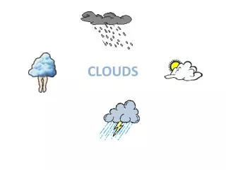
Where clouds form • Word parts indicate where clouds form and describe appearance • Strato – layered clouds, usually form below 6,500 feet • Cumulo – fluffy clouds that grow upward • Alto - between 6,500 and 20,000 feet • Cirro – feathery clouds forming above 20,000 feet • Nimbo– refer to dark rain clouds
High Level Clouds • Bases above 20,000 ft (7,000 m) • Composed of ice crystals • Types: Cirrus, cirrocumulus, cirrostratus
High level clouds:Cirrus Clouds • Thin, wispy, and fibrous, hair-like in appearance • Indicate fair weather
High level clouds • Cirrocumulus –extremely high • Occur before snowfall, made entirely of ice • Cirrostratus – indicate snow or rain, blanket sky • Produce halos around Sun and moon
Middle level clouds • Bases between 6,500 and 20,000 ft • Associated with light precipitation • Contain ice crystals and/or water droplets • Types: Altocumulus and Altostratus
Middle level clouds: Altocumulus • Puffy with noticeable height piling upward • Commonly followed by thunderstorms
Middle level clouds: Altostratus • More uniform coverage, still layered • Gray or bluish in color • Indicates an approaching thunderstorm or cyclone
Low Level Clouds • Bases lie below 6,500 ft (2,000 m) • Mostly water droplets • Some ice crystals in cold climates • Types: Nimbostratus, Cumulonimbus, Stratocumulus, Stratus, and fog
Low level clouds • Nimbostratus • Dark gray, layered clouds • Produce steady rain • Cumulonimbus • Also low level, but produce heavy rain, thunder, lightning, or hail
Low level clouds: Stratus Clouds • Substantial, flat or layered • Appear before thunderstorms, but produce little precipitation • Usually the lowest • Appear overcast
Low level clouds: Stratocumulus • Layers of puffy clouds, flat on top • Often cover sky in winter • Can produce precipitation
Low level clouds:Fog • “Cloud” that is touching the ground • Becomes stratus when it lifts