Download
1 / 6
60 likes | 201 Vues
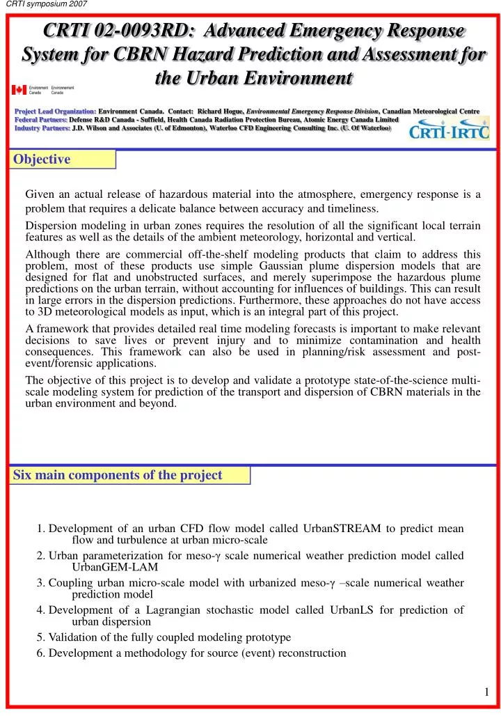
CRTI symposium 2007. CRTI 02-0093RD: Advanced Emergency Response System for CBRN Hazard Prediction and Assessment for the Urban Environment Project Lead Organization: Environment Canada. Contact: Richard Hogue, Environmental Emergency Response Division , Canadian Meteorological Centre

E N D
CRTI symposium 2007 CRTI 02-0093RD: Advanced Emergency Response System for CBRN Hazard Prediction and Assessment for the Urban Environment Project Lead Organization: Environment Canada. Contact: Richard Hogue, Environmental Emergency Response Division, Canadian Meteorological Centre Federal Partners: Defense R&D Canada - Suffield, Health Canada Radiation Protection Bureau, Atomic Energy Canada Limited Industry Partners: J.D. Wilson and Associates (U. of Edmonton), Waterloo CFD Engineering Consulting Inc. (U. Of Waterloo) Objective Given an actual release of hazardous material into the atmosphere, emergency response is a problem that requires a delicate balance between accuracy and timeliness. Dispersion modeling in urban zones requires the resolution of all the significant local terrain features as well as the details of the ambient meteorology, horizontal and vertical. Although there are commercial off-the-shelf modeling products that claim to address this problem, most of these products use simple Gaussian plume dispersion models that are designed for flat and unobstructed surfaces, and merely superimpose the hazardous plume predictions on the urban terrain, without accounting for influences of buildings. This can result in large errors in the dispersion predictions. Furthermore, these approaches do not have access to 3D meteorological models as input, which is an integral part of this project. A framework that provides detailed real time modeling forecasts is important to make relevant decisions to save lives or prevent injury and to minimize contamination and health consequences. This framework can also be used in planning/risk assessment and post-event/forensic applications. The objective of this project is to develop and validate a prototype state-of-the-science multi-scale modeling system for prediction of the transport and dispersion of CBRN materials in the urban environment and beyond. Six main components of the project • Development of an urban CFD flow model called UrbanSTREAM to predict mean flow and turbulence at urban micro-scale • Urban parameterization for meso-γ scale numerical weather prediction model called UrbanGEM-LAM • Coupling urban micro-scale model with urbanized meso-γ –scale numerical weather prediction model • Development of a Lagrangian stochastic model called UrbanLS for prediction of urban dispersion • Validation of the fully coupled modeling prototype • Development a methodology for source (event) reconstruction 1
CRTI symposium 2007 Concept Plume Dispersion Models Fluid Dynamics Models Mesoscale Mesoscale Operational Model GEM 15km MLPD BCs Urban scale Urban scale urbanLS urbanEU “Urbanized” GEM/LAM Cascade 2.5km – 1km- 250m BCs Building scale Building scale urbanSTREAM CFD model Defines Flow Defines Dispersion Source Type UrbanLS dispersion model • CBRN releases induces impacts over many spatial scales • Need multi-scale approach where flow and dispersion are performed within “nested” domains Chemical agent Biological agent Radiological agent Prototype 3D buildings data Visualization Product generation UrbanLS UrbanEU UrbanSTREAM UrbanGEM/LAM Bayesian inference for inverse source determination urbanBLS urbanAEU MEASUREMENTS and OBSERVATIONS MODELING DATABASES TRANSFERS • Surface fields • Anthropogenic • heat sources • Meso- and off-line • Regional NWP • MUSE-1 (2005) • MUSE-2 (2006) • TEB • 3D-turbulence • Boundary conditions 2
CRTI symposium 2007 Prototype implementation A full prototype of the modeling system has been implemented in the computing environment of a government operations centre at the Canadian Meteorological Centre’s (CMC) Environmental Emergency Response Division (EERD). Application in test mode of hypothetical release to Vancouver and Montreal 2.5km 1km 250m Vancouver - urban classification GEM-LAM - Vancouver cascade configuration Vertical cross-section of concentration Wind vectors Isosurface of concentration level of material 3D streamlines Prototype also running over Montreal Accumulated concentration at ground level 3
CRTI symposium 2007 Joint Urban 2003: Atmospheric flow and dispersion study held in Oklahoma City in July 2003. 10 Intensive Observing Periods (IOPs): 6 day’s IOPs and 4 night’s IOPs. Validation Measured and Predicted Concentration Wind at 2m AGL UrbanStream Source Experimental urbanEU Isopleths of concentration field, UrbanLS model urbanAEU urbanLS UrbanGEM validation: Oklahoma City, IOP9 From JU03, Illustration of the Urban Heat Island Fig. 1 Fig. 2 Figure 1 Figure 2 Figure 3 Fig. 3 Fig. 1: 12 rural Stations (MESONET) Fig. 2: 13 urban Stations (PWIDS) Fig. 3: Canopy level UHI positive at night, negative at day Δθ Urban effects at night: Figure 1: θ = Potential Temperature at 50m AGL and at time 0600 LST Figure 2: Δθ = θ(Urban)–θ(Rural) at 50m AGL and at time 0600 LST Figure 3: ▪ Vertical extension of the UHI in the first 200 m ▪ Decrease of the vertical extension during the night Montreal Urban Snow Experiment (MUSE) ▪ Field campaign to document the evolution of surface characteristics and energy budgets in a dense urban area during the winter-spring transition. The results are used to validate the meso-scale model’s urban surface scheme in such conditions. ▪ MUSE-2005 (February-March 2005), MUSE 2006 (January-March 2006) ▪ 4 IOPs Turbulent Fluxes:▬ Qh and ▬ Qe 4
CRTI symposium 2007 Recent Results Inverse Source Determination and Bayesian Inference (component 6): Application to Oklahoma City using 4 detectors Actual source location: 74 (xs, zs) = (3.2506,1.5537) N Distributed drag force representation • Application examples: • Localization of leakage of toxic gases and other pollutants (regulatory application) • Terrorist incidents – localization of unknown source following event detection by network of CBRN sensors (“electronic noses”) as quickly as possible • Comprehensive Nuclear Test Ban Treaty (CTBT) “sniffing” out clandestine nuclear tests (133Xe - Xenon) network Detector Source 5
CRTI symposium 2007 Links to other projects • CRTI projects: • Application of prototype to provide simulation scenarios to project CRTI 05-0058TD - “Unified Interoperability Solution set to Support CONOPS Framework Development -- Municipal-Provincial-Federal Collaboration to CBRN Response” • Application as input to ARGOS system under CRTI 01-0080TA “Information Management and Decision Support System for Radiological-Nuclear (RN) Hazard Preparedness & Response” • Application to consider precipitation scavenging under CRTI 02-0041RD “Real Time Determination of Area of Influence of CBRN Releases” • Application to high resolution situations of dispersion around infected barns and biological releases under CRTI 02-0066RD “Development of simulation programs to prepare against and manage outbreaks of highly contagious diseases of animals” • Links with dispersion assessment under CRTI 03-0018RD “Experimental Characterization of Risk for Radiological Dispersal Devices (RDDs)” • Links with dispersion assessment under CRTI 05-0014RTD “Experimental and Theoretical Development of a Re-suspension Database to Assist Decision Makers during a RDD Event” EPiCC (Environmental Prediction in Canadian Cities), a project underCFCAS(The Canadian Foundation for Climate and Atmospheric Sciences) which aims to better understand meteorological processes in Canadian cities. Emphasis and detailed observational field studies are being implemented over Vancouver and Montreal. Next steps Project now 90% complete, ends March 2008 • Finalize work on inverse source determination and validation over OKC • Finalize documentation of all aspects of the project • Finalize technical aspects of prototype installation over Montreal and Vancouver (validation of UrbanGEM-LAM cascade (bi-monthly basis) and test dispersion scenarios) • Examine the possibility of using the validation datasets from the New-York tracer experiment • Submitted a follow-up proposal project: CRTI-06-0198TD: "Towards an Operational Urban Modeling System for CBRN Emergency Response and Preparedness"; Aims the implementation of the prototype to 9 major Canadian cities in a technology demonstration context as well as improvements to the prototype components and further validation. Important aspect is a better linkage with the user community and focus on preparation for Vancouver 2010 Olympics. 6