Download
1 / 17
170 likes | 271 Vues
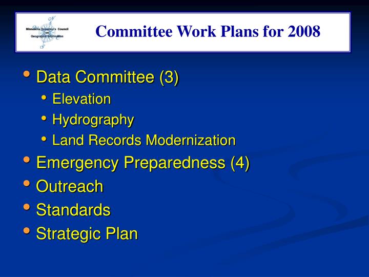
Committee Work Plans for 2008. Committee Workplans. Data Committee (3) Elevation Hydrography Land Records Modernization Emergency Preparedness (4) Outreach Standards Strategic Plan. Data Committee - Elevation.

E N D
Committee Work Plans for 2008 Committee Workplans • Data Committee (3) • Elevation • Hydrography • Land Records Modernization • Emergency Preparedness (4) • Outreach • Standards • Strategic Plan
Data Committee - Elevation • Assist in the development of partnerships that support data collection projects • Develop a work team to investigate funding opportunities including prospects for LCCMR grants • Populate the Statewide Elevation and Imagery Inventory (SEII) with information that links data collection projects • Support data services that host data resources and deliver them economically • Work with DNR and others to determine physical specifications required to serve very large elevation databases • Establish architecture to optimize data access • Establish governance policies that assign roles and responsibilities for data import, maintenance and access applying that architecture
Data Committee - Elevation Deliver technical standards and information to partners to ensure coordinated data collection Level I • Create and maintain a web site containing all critical documents, white papers, guidelines, policies and best practices to meet a statewide elevation data goal • Design and present a workshop session that addresses the most important questions of county and local government • Update brochure Level II • Develop a work team that will establish critical technical specifications for high resolution digital elevation data that meet FEMA requirements • Develop a work team that will study data collection costs and establish guidelines to guide budgets • Prepare a white paper and briefing paper for a legislative proposal for statewide high resolution digital elevation data coverage
Data Committee - Hydrography Future Initiatives: • Implement plan for use and maintenance of the framework (EPA Grant) • Refine roles and responsibilities • Assess data access and maintenance needs of MN users • Encourage and implement data enhancements and updates • Foster development and sharing of applications and tools • Explore improved linkages between NHD and DNR 24K hydrography layers • Resolve FGDC Compliance issues for MN Watershed Boundaries • Develop wetlands mapping and maintenance strategy • Review and comment on FGDC Wetland Mapping Standard
Data Committee - LRM • The Land Records Modernization Committee will be reforming to explore next steps. • Potential activities include: • Complete Parcel Data Creation Guide begun by committee in 2005 • Create publication on "Getting Parcel Data Funded" - idea from 2005 • Explore how Minnesota cadastral data fits with national standards • Others - as defined by the interested and willing participants! • Will be recruiting at council meeting and through MN GIS/LIS Consortium. Will call initial meeting to determine interest, focus and potential goals in December or January.
Emergency Preparedness Committee Major Accomplishments Thus Far • Committee reorganization and re-focus • Major rework of EPC Public Web Site • Created EPC SharePoint from scratch • Rochester MN GIS/LIS Consortium Convention Recruiting Effort (Growth from 17 to 65) • Developed comprehensive Work Group Vision Statement with 51 Specific Tasks
Emergency Preparedness Committee Outreach Work Group – Chair: Carla Coates • 21 SPECIFIC TASKS • Distribute Emergency Preparedness informational items by email • Create and send out electronic EPC promotional flyers as a recruiting tool • Develop recognition program for EPC participation • Recruit GIS professionals to help with local EM plans
Emergency Preparedness Committee Education Work Group – Chair: Dan Anderson • 9 SPECIFIC TASKS • Identify a basic course of instruction for participation on the EPC • Set up and maintain a training course to certify GIS professionals with (MN) qualifications in EM, and vice versa for EM professionals • Build and maintain a training opportunities calendar on the EPC web site • Arrange topic specific training seminars (like HAZUS) throughout Minnesota
Emergency Preparedness Committee Data Work Group – Chair: Jeff Bloomquist • 13 SPECIFIC TASKS • Create a command and control data layer for Minnesota • Identify and promote standard Emergency Preparedness symbology • Take ownership of the HSIP process in Minnesota • Devise a hierarchy of GI for EM based on available technology
Emergency Preparedness Committee “Go Team” Work Group – Chair: TBD • 8 SPECIFIC TASKS • Create an EOC GIS test bed (EOC in a Box) • Identify equipment and procedures to be used to provide GIS support to HSEM and other EOC’s, either onsite or remote • Develop a Common Operating Picture “Way Forward” and support the grant writing process to acquire funds that will make it a reality • Create a program to qualify GIS personnel for EOC augmentation
Emergency Preparedness Committee Long Term • FUSION OF THE MINNESOTA EMERGENCY MANAGEMENT COMMUNITY • (CUSTOMER) • AND GIS COMMUNITY • (PROVIDER)
Outreach Committee Outreach Committee Work Plan2007 - 2008 • Explore other organizational relationships. • Participate in GIS/LIS, IT, MSPS, and other conferences. • Update Communication Plan, including new organizations and a new conference schedule chronology. • Explore ways of distributing more Council messages through GIS/LIS e-announcements and electronic postings to other organizations.
Outreach Committee • Update Operating Policies to encourage letters of support. • Complete new brochure and post on web for download. • Support Council and Committee efforts to develop and implement governance and collaboration models. • Encourage GIS/LIS Consortium efforts to implement a Speakers Bureau. • Write articles for newsletters. • Draft Annual Report.
Standards Committee • Resolution to the state standards approval process = clearly defined authorizing body and approval process • State response to the FGDC Wetland Mapping Standard • State review and response to the National Street Address Standard • Creation of a state municipal identifier standard based on GNIS
Standards Committee • Put in place a sustainable and responsive process to keep the municipal identifier standard up to date. • Review of MN Geographic Metadata Guidelines and probably modification base on changes to FGDC and ISO standards • New guidelines or standards for metadata for web mapping services.
Strategic Plan Committee Committee Purpose: • Guide strategic developments to establish a recognized coordinating entity for state government GIS, recognizing and including the state’s partners and customers. • Supports Council FY 2008 goal of State Governance model, addressing goals detailed in “A Foundation for Coordinated GIS” • Primary Vehicle: Drive to Excellence Project
Strategic Plan Committee Work Plan: • Organizational Transformation: • Business Case & Project Charter for Drive Project • Functional Transformation: • RFI & SOW for consultant to examine state’s functional requirements Goal: complete both by June/July 2008