Download
1 / 14
160 likes | 399 Vues
Tools of GEO and MAPS: How do we use them???. Research methods/TOOLS used to study Geography:. Direct Observation – visiting a region, aerial photos & satellite Mapping / Cartography – study & making maps Statistics - math Technology Graphic information systems (GIS)

E N D
Research methods/TOOLS used to study Geography: • Direct Observation – visiting a region, aerial photos & satellite • Mapping / Cartography – study & making maps • Statistics - math • Technology • Graphic information systems (GIS) • Definition: computer systems that store and analyze geographic data (ex: GOOGLE Earth) • Global Positioning system (GPS) • Definition: a system that uses satellites and receivers to determine absolute location
T.O.D.A.L.S.I.G.S.’s. • T is for TITLE: What is this map of? • O is for Orientation: Compass Rose • D is for Date: When was this map created? • A is for Author: Who created this map?
L is for LEGEND: What do the things on this map represent? (think key!)
S is for SCALE • Map Scale is the ratio of the distance on the map to the distance on the ground Large Scale Small Scale
***One inch on a map could equal 1,000 kilometers in real life! It shows us distance! SCALE
I is for Index: What does the map include? • Used usually in books of maps called ATLASES
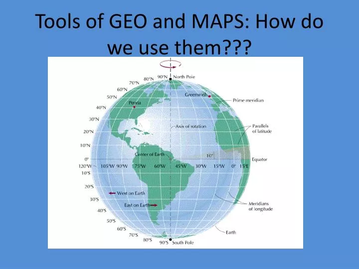
G is for Grid System • Combining Longitude and Latitude allow people to identify exact locations of places on the earth (absolute location) • (DON’T COPY below) • Example: • Denver is found at 39 degrees North Latitude and 104 degrees West Longitude
GRID: Meridian (Longitude) • Lines that run north and south or vertical: divide world into Eastern Hemisphere and Western Hemisphere • 0 degrees called Prime Meridian • Goes through Greenwich, England • 180 degrees is called the International date line: Cross the line from the east to the west and a day is added. Cross from west to the east and a day is subtracted
GRID: Parallels (Latitude) • Imaginary lines that run west to east or horizontal • 0 degrees latitude called equator • Two other major parallels are the Tropic of Cancer and the Tropic of Capricorn -located 23 ½ degrees above and below the equator
S is for source: What did you use to make this map? (IF not obtained by direct experience or observation)… GIVE CREDIT! • ’s is for: surrounding areas (places or features that border the map)
MAP ACTIVITY • Create a map of your home or school using the TODALSIGS’s • You don’t have to include I or G • For the key, color code rooms or buildings and include symbols for things like trees if necessary • It should look like a blueprint (like you’ve chopped off the roof of your house and you’re looking down at it)
“Know Your World”: MAP Activity #2 • Label the areas on the maps with the letters given. • Bodies of Water (label and color blue): Oceans (4), Mediterranean/Black/Aral/Norwegian/North/Caspian/Red Seas and Sea of Japan (8), Gulf of Mexico, Mississippi River, Nile River, Volga River, Rio Grande, Danube River, Persian Gulf, English Channel • Land (label): Continents(7), Rocky Mts., Himalaya Mts., Sahara Desert, Alps (Mts.), Carpathian Mts., Ural Mts. • Find (write on back): examples of a Peninsula, Archipelago, plateau • Find Latitude and Longitudes for (label, write on back): New York City; Tokyo, Japan; Moscow, Russia; Cape town, South Africa; Mexico City, Mexico; London, England; Paris, France; Buenos Aires, Argentina; Munich, Germany; Constantinople, Turkey; Rome, Italy; Sydney, Australia….. Include a city of your choice as well! • IF THINGS DON’T FIT…. Create a KEY! (TODALSIG’s!)