Download
1 / 20
200 likes | 325 Vues
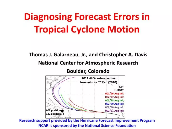
Diagnosing Forecast Errors in Tropical Cyclone Motion. Thomas J. Galarneau, Jr., and Christopher A. Davis National Center for Atmospheric Research Boulder, Colorado. 2011 AHW retrospective forecasts for TC Earl (2010). KEY HURDAT 00Z/26 Aug Init 00Z/27 Aug Init 00Z/28 Aug Init

E N D
Diagnosing Forecast Errors in Tropical Cyclone Motion Thomas J. Galarneau, Jr., and Christopher A. Davis National Center for Atmospheric Research Boulder, Colorado 2011 AHW retrospective forecasts for TC Earl (2010) KEY HURDAT 00Z/26 Aug Init 00Z/27 Aug Init 00Z/28 Aug Init 00Z/29 Aug Init 00Z/30 Aug Init 00Z/31 Aug Init 00Z position 12Z position Research support provided by the Hurricane Forecast Improvement Program NCAR is sponsored by the National Science Foundation
Diagnosing Forecast Errors in Tropical Cyclone Motion Goal: To develop a diagnostic equation that will quantitatively diagnose forecast errors in tropical cyclone (TC) motion for any NWP model. Thomas J. Galarneau, Jr., and Christopher A. Davis National Center for Atmospheric Research Boulder, Colorado 2011 AHW retrospective forecasts for TC Earl (2010) KEY HURDAT 00Z/26 Aug Init 00Z/27 Aug Init 00Z/28 Aug Init 00Z/29 Aug Init 00Z/30 Aug Init 00Z/31 Aug Init 00Z position 12Z position Research support provided by the Hurricane Forecast Improvement Program NCAR is sponsored by the National Science Foundation
Background • TC forecast track errors commonly related to wind errors associated with synoptic-scale weather systems nearby the TC • e.g., Carr and Elsberry (2000); Brennan and Majumdar (2011) • TC motion is controlled primarily by the environment wind in the 700–500 mb layer or tropospheric-deep-layer driven by nearby weather systems and the Beta effect • e.g., George and Gray (1976); Holland (1983); Fiorino and Elsberry (1989); Velden and Leslie (1991) • TC motion also influenced by: • interaction with landmasses and the underlying ocean (e.g., Bender et al. 1993) • balanced motion in response to vertical shear (e.g., Wang and Holland 1996)
Data • 0.5° Climate Forecast System Reanalysis (Saha et al. 2010) • NHC Best Track (HURDAT) • 2011 retrospective Advanced Hurricane WRF (AHW) forecasts (36-km domain only)
Steering Flow Definition • The environment wind (venv) is the residual wind that results from the removal of local winds associated with the TC vortex • Remove all ζ and δ within a radius, r • The steering flow is the spatially averaged venv that matches the TC motion, and so is a function of venv
Steering Flow Computation • Compute an area-average venv every 50 mb in the 850–200 mb layer using eight different radii ranging from 1°–8° from the TC center • Compute the pressure-weighted vertical average venv for layers of increasing depth • shallowest layer of 850–800 mb • deepest layer of 850–200 mb • Select the steering flow depth and radius combination that best matches TC motion • minimize steering layer residual error
TC Motion Error Diagnostic area-average observed venv observed radius Vm−Vo 6 9 Vo Vm area-average AHW venv AHW radius rm 6 9 6 9 ro area-average AHW venv observed radius +steering residual +steering residual AHW storm motion observed optimal steering flow AHW optimal steering flow observed storm motion
TC Motion Error Diagnostic Vm−Vo 6 9 Vo Vm rm 6 9 6 9 ro storm motion error venv error radius error depth error
Synoptic Overview 200 mb PV (shaded in PVU), wind (arrows in m s−1), and 850 mbζ (contours every 8.0×10⁻⁵ s−1) Danielle Earl Fiona Fiona Earl Gaston 0000 UTC 29 August 2010 0000 UTC 2 September 2010
Motion Error Diagnosis: TC Earl 24-h AHW Forecasts Verifying 0000 UTC 27 Aug–1 Sep 2010 • venv error is largest contributor to motion error overall • Depth and radius error terms can be large at individual times Actual Environment TC removal radius Vertical Depth Residual v00Z/1 v00Z/31 v00Z/30 v00Z/29 v00Z/28 v00Z/27 1.0
venv Error for AHW 24-h Forecast verifying at 0000 UTC 27 Aug 600 mb Z and Z error (AHW–CFSR) 850–450 mbvenv error (AHW–CFSR) • venv error in conjunction with weak subtropical ridge in AHW x x v00Z/27
Depth Error for AHW 24-h Forecast verifying at 0000 UTC 29 Aug AHW Depth Perturbation Wind (CFSR) • Depth error in conjunction with shallower steering layer in AHW; weaker/shallower vortex x Observed depth 850–200 mb AHW depth 850–350 mb v00Z/29
Radius Error for AHW 24-h Forecast verifying at 0000 UTC 31 Aug • Radius error in conjunction with near-vortex asymmetries in AHW v00Z/31 Observed radius 4° AHW radius 2°
Radius Error for AHW 24-h Forecast verifying at 0000 UTC 31 Aug AHW 850–300 mb Radius Perturbation Wind • Radius error in conjunction with near-vortex asymmetries in AHW x v00Z/31 Observed radius 4° AHW radius 2°
Concluding Remarks • We developed a method for computing steering layer flow and diagnosing TC motion errors in any NWP model • The diagnostic equation allows quantification of the intersection between TC structure and position errors • Analysis of AHW forecasts for TC Earl (2010) show that: • venv errors are the largest contributor to TC motion errors overall -> Linked to subtropical ridge errors • Other terms can be large for individual forecasts
TC Earl (2010) Motion Error Diagnosis 2011 AHW Retrospective 24-h Forecasts v00Z/1 v00Z/31 v00Z/30 v00Z/29 v00Z/28 v00Z/27 1.0 Actual Environment TC removal radius Vertical Depth Residual 2012 AHW Retrospective 24-h Forecasts v00Z/1 v00Z/31 v00Z/30 v00Z/29 v00Z/28 v00Z/27
TC Earl (2010) 600 mb Z Error Subtropical ridge problem not as prominent in retro12 2011 AHW Retrospective 2012 AHW Retrospective X X Ret12 error diagnosis v00Z/27 Ret11 error diagnosis v00Z/27 Inclusion of aerosols (not shown) in retro12 forecasts contributed to improvements of subtropical ridge structure and reduced environment wind errors 24-h AHW Forecast verifying at 0000 UTC 27 August 2010
Errors Associated with Convection in Vertical Shear (0000 UTC 31 Aug) • Convection more asymmetric in AHW in conjunction with stronger vertical shear Observed depth 850–350 mb AHW depth 850–300 mb v00Z/31
Errors Associated with Convection in Vertical Shear (0000 UTC 31 Aug) venv Profile at v00Z/31 Aug • Algorithm will attempt to find steering layer that best matches TC motion influenced by convection; can result in steering depth error Observed depth 850–350 mb AHW depth 850–300 mb v00Z/31