Download
1 / 24
240 likes | 350 Vues
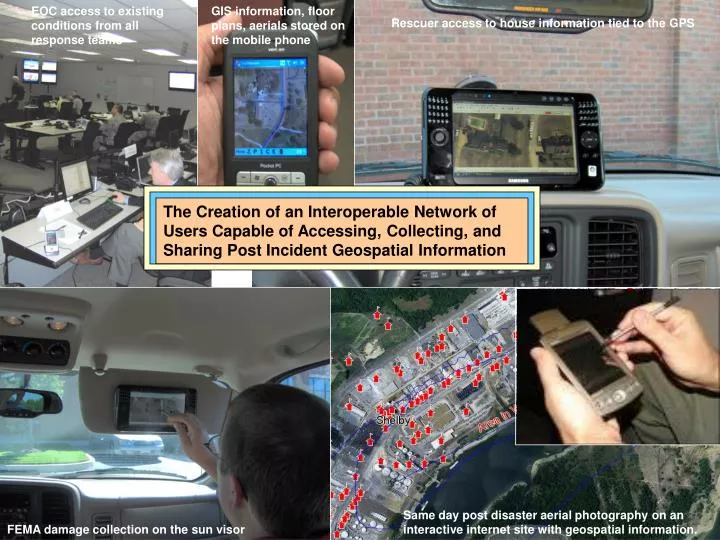
EOC access to existing conditions from all response teams. GIS information, floor plans, aerials stored on the mobile phone. Rescuer access to house information tied to the GPS.

E N D
EOC access to existing conditions from all response teams GIS information, floor plans, aerials stored on the mobile phone Rescuer access to house information tied to the GPS The Creation of an Interoperable Network of Users Capable of Accessing, Collecting, and Sharing Post Incident Geospatial Information Same day post disaster aerial photography on an interactive internet site with geospatial information. FEMA damage collection on the sun visor
EOC access to existing conditions from all response teams GIS information, floor plans, aerials stored on the mobile phone Rescuer access to house information tied to the GPS • The Creation of an Interoperable Network of Users Capable of Accessing, Collecting, and Sharing Post Incident Geospatial Information • Rescuers and responders need immediate spatial (map) and database information about their affected area after a major disaster. Same day post disaster aerial photography on an interactive internet site with geospatial information. FEMA damage collection on the sun visor
EOC access to existing conditions from all response teams GIS information, floor plans, aerials stored on the mobile phone Rescuer access to house information tied to the GPS • The Creation of an Interoperable Network of Users Capable of Accessing, Collecting, and Sharing Post Incident Geospatial Information • Rescuers and responders need immediate spatial (map) and database information about their affected area after a major disaster. • The lack of cell towers in the first 24-72 hours means information for rescuers and responders must be self contained. It must be accessible, fast, updated, and easy to use. Same day post disaster aerial photography on an interactive internet site with geospatial information. FEMA damage collection on the sun visor
EOC access to existing conditions from all response teams GIS information, floor plans, aerials stored on the mobile phone Rescuer access to house information tied to the GPS • The Creation of an Interoperable Network of Users Capable of Accessing, Collecting, and Sharing Post Incident Geospatial Information • Hundreds of government field personnel need immediate spatial (map) and database information about their affected area after a major disaster. • The lack of cell towers in the first 24-72 hours means information for rescuers and responders must be self contained. It must be accessible, fast, updated, and easy to use. • The concept, called RAIN, was successfully field tested during the SONS07 exercise. Same day post disaster aerial photography on an interactive internet site with geospatial information. FEMA damage collection on the sun visor
EOC access to existing conditions from all response teams GIS information, floor plans, aerials stored on the mobile phone Rescuer access to house information tied to the GPS • The Creation of an Interoperable Network of Users Capable of Accessing, Collecting, and Sharing Post Incident Geospatial Information • Rescuers and responders need immediatespatial (map) and database information about their affected area after a major disaster. • The lack of cell towers in the first 24-72 hours means information for rescuers and responders must be self contained. It must be accessible, fast, updated, and easy to use. • The concept, called RAIN, was successfully field tested during the SONS07 exercise. • Expand the network into other areas. The network can tie local, county, and state agencies. Same day post disaster aerial photography on an interactive internet site with geospatial information. FEMA damage collection on the sun visor
On June 19th, 2007, the first day of the SONS07/TNCAT exercise, 33 teams from 18 jurisdictions in three states successfully tested the RAIN concept tying together the mobile user, the EOC, and the internet. Bridge Damage RAIN screen shot from the mobile device showing existing conditions collected in the field for team 3. Hazmat Damage Major Utility Damage
State EOC Mobile Data Terminal Access SONS07/TNCAT/RAIN Exercise State EOC Mobile Phone Access State EOC EOC and internet Access June 19th, 2007 “The RAIN network allows local entities to better take care of themselves in the first 24-72 hours after a major incident before outside assistance arrives and before cell towers are available. It also provides the EOC and mobile responders with critical information on the existing conditions in their affected area within a couple of hours after the incident in an effort to make quicker, and better informed decisions.” RAIN (Rescuer/Responder Assistance Information Network)
RAIN Concept Evaluation The RAIN concept was originally presented to the CUSEC board of directors (primarily state EMA directors) in December 2005 for comments about the concept and technology presented. All of their suggestions were incorporated into the RAIN exercise. The board identified three conditions that must be addressed for any emergency management field technology to be practical in a rescuer/response situation; • “Cell towers will not be usable for at least the first 24-48 hours. Wireless communication in the field will not be available. Do not include it in your plans. The rescuer/responder must be totally self contained”. • Internet access may be available at the EOConly via (satellite internet), • “GPS must be included in the technology for the responder since conventional street signs and other landmarks may not be available, as was the case with Katrina.” The board also suggested the SONS07 exercise in June of 2007 would be the best test of the technology and concept. Charles Bryant and Claude Talford as well as others made their EOCs available to test the RAIN concept and technology. RAIN (Rescuer/Responder Assistance Information Network)
Bridge Damage RAIN screen shot from the mobile device showing existing conditions collected in the field for team 3. 7 goals achieved during RAIN • Remote access to critical information by rescuers/responders on mobile devices • Creation of a network of interoperable users of RAIN information • Collection of standardized “existing conditions” post disaster information made available to the EOC in 90 minutes. • Greatly improved the FEMA damage reporting system. • Shared critical spatial information between EOCs within an hour of the disaster. • Non network approved users could access critical information via a secured interactive internet site. • Post Disaster digital aerial photography was shot and made available in hours to the EOCs. Hazmat Damage Major Utility Damage
Goal #1 RAIN Goals- Access by Recuers/Responders • Local storage of all information, multiple counties at once. Digital orthos included. • Query capabilities • Very fast, very easy to use, very inexpensive. Search and Rescue (SAR) Mobile Capabilities • Was there a structure here? • Was it vacant? • Who owns it and what is the address? • Do we have a floor plan? • Do they have a cell phone? What’s the number? • Did the red car we found go to this structure?
Goal #2 RAIN Goals- Increase the network density by including others • Increase the density of the network by including non public safety personnel that are already in the field. Probably first on scene anyway. Increased 4 fold. • We already have seven agencies already using the mobile devices for non public safety needs. • We can switch to EMA in 5 seconds and have the RAIN information. Code Enforcement Inspectors CERT Streets/Hwy Utilities Engineering
Goal #3 RAIN Goals- Standardized existing conditions are collected and available very quickly Relay seven major categories of “existing conditions” information from the rescue/responder personnel in the field to the EOC after an incident. The faster the data arrives… the more impact it has on better, faster decision-making in the EOC. RAIN Exercise Results 33 teams collected “existing conditions” information on roads, bridges, utilities, HazMat, injuries, trees/vegetation, and fires. Thirty teams had them available on the EOC screen in 90 minutes. Two teams took 2 hours, and one took longer. Tree/Vegetation form
Goal #4 RAIN Goals- Greatly improve the FEMA damage reporting Significantly improved the speed of compiling FEMA-required damage reporting requirements for structures. Compiling data typically takes days, ties up personnel and delays the release of funding and assistance. RAIN Exercise Results • Reduced the compilation time by almost 400%. Some teams chose to collect only existing conditions, then return later to collect FEMA damage. Others collected all at once because it was so fast. This also eliminates calling damage collectors into the EOC for instructions before mobilization, another major time saver. This also eliminated any work in the office later. Since the FEMA damage collection was completed so quickly it was available in the EOC the first day, making it a valuable tool in the assessment of the incident. CERT Code Enforcement Fire Inspectors
Goal #5 RAIN Goals- The EOC shares standardized information with other EOCs Significantly improve the speed for compiling and sharing data from the local EOC to others. Once the EOC compiles the field “existing conditions” information, the EOC needs to be able to query the information by location and type, making it available to other EOCs. RAIN Exercise Results The information was compiled in the Memphis/Shelby County EOC as well as the TNCAT EOC in Jackson, TN. in about 5 minutes and made available to EOC users immediately. This allowed them to make informed decisions quickly with excellent information. Local EOC sent information to others in the RAIN network Compiled in Your Local EOC, Then Relayed to the Appropriate EOCs Based on the Extent of Damage
Goal #6 RAIN Goals- Share critical information via the internet • Approved non EOCs can acquire updated existing conditions via an interactive internet site. RAIN Exercise Results • Approved users, outside the affected area, were able to make informed decisions within 3-4 hours after the incident. Compiled in Your Local EOC, then posted to the interactive internet site for all approved users WWW.
Goal #7 RAIN Goals- Make post disaster aerials available in a few hours • Responders and EOC staff desperately need post disaster aerial photography immediately, to better make informed decisions. RAIN Exercise Results • We collected about 100 square miles of digital high resolution color post disaster aerial photography the morning of the RAIN exercise and had it in the EOC on the screen in 4 hours. It was on the internet in 5 hours and the mobile devices in 6 hours.
EOC access to existing conditions from all response teams GIS information, floor plans, aerials stored on the mobile phone Rescuer access to house information tied to the GPS Next Steps Expand RAIN immediately in the Memphis and Mid-South areas that would be impacted by a major earthquake. Set up a storage, distribution, and deployment area. Same day post disaster aerial photography on an interactive internet site with geospatial information. FEMA damage collection on the sun visor
Pilot Project Area 1812 7.7 Earthquake Tipton Co. Crittenden Co. Fayette Co. Shelby Co. DeSoto Co.
EOC access to existing conditions from all response teams GIS information, floor plans, aerials stored on the mobile phone Rescuer access to house information tied to the GPS Next Steps Expand RAIN immediately in the Memphis and Mid-South areas that would be impacted by a major earthquake. Set up a storage, distribution, and deployment area. Present the RAIN concept to agencies outside Memphis that may be affected by a natural or manmade incident or disaster of any size. Evaluate potential participants. Same day post disaster aerial photography on an interactive internet site with geospatial information. FEMA damage collection on the sun visor
EOC access to existing conditions from all response teams GIS information, floor plans, aerials stored on the mobile phone Rescuer access to house information tied to the GPS Next Steps Expand RAIN immediately in the Memphis and Mid-South areas that would be impacted by a major earthquake. Set up a storage, distribution, and deployment area. Present the RAIN concept to agencies outside Memphis that may be affected by a natural or manmade incident or disaster of any size. Evaluate potential participants. Expand from 7 non public safety user agencies to 12 in 2007-2008. Code Enforcement, Public Works, Utilities, and Engineering. Same day post disaster aerial photography on an interactive internet site with geospatial information. FEMA damage collection on the sun visor
EOC access to existing conditions from all response teams GIS information, floor plans, aerials stored on the mobile phone Rescuer access to house information tied to the GPS • Summary • Rescuers and responders need immediate spatial (map) and database information about their affected area after a major disaster. • The lack of cell towers in the first 24-72 hours means information for rescuers and responders must be self contained. • The concept, called RAIN, was successfully field tested during the SONS07 exercise. • The implementation of RAIN by an agency could have a major impact on the ability to respond to a major incident. Same day post disaster aerial photography on an interactive internet site with geospatial information. FEMA damage collection on the sun visor
EOC access to existing conditions from all response teams GIS information, floor plans, aerials stored on the mobile phone Rescuer access to house information tied to the GPS The RAIN network of users makes it easy for the EOC and emergency management staff to quickly access “existing conditions” after an incident and pass it to others with unprecedented capabilities and speed. Rick Stieg Vic Young - F&A - 901-748-1811 Vyoung@fisherarnold.com For information contact Same day post disaster aerial photography on an interactive internet site with geospatial information. FEMA damage collection on the sun visor