Download
1 / 44
460 likes | 600 Vues
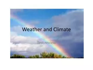
Climate and Weather. Section 2.3, p.33. Weather. This is a description of atmosphere conditions from day to day. Ex. It’s sunny and warm now. Climate. This is the pattern of weather conditions over a long period of time. Ex. It’s not that warm in June in Newfoundland. Global Factors.

E N D
Climate and Weather Section 2.3, p.33
Weather • This is a description of atmosphere conditions from day to day. • Ex. It’s sunny and warm now.
Climate • This is the pattern of weather conditions over a long period of time. • Ex. It’s not that warm in June in Newfoundland.
Global Factors • The earth’s “controls” that result in different types of weather and climate. There are 4 global factors: • 1. Latitude • 2. Air Masses and Winds • 3. Ocean Currents • 5. Clouds and Precipitation
1st Latitude • Farther from the equator the average monthly temperature decreases. • Higher latitude locations get less direct sunlight. • Sunlight strikes these high altitudes at an angle. The sun has to heat up a bigger area. • Areas closer to the equator have more intense radiation. • Ex. Canada is, on average, • colder than the USA.
2nd Air Masses and Winds(P. 34) • These are large bodies of air with a few predictable atmospheric features. • They move toward Canada and influence our weather and climate. • They are formed in certain places on Earth. • They have different characteristics that are reflected in their name.
2. Air Masses and Winds • Maritime Tropical – warm water makes the air warm and moist (warm moist summer air from the south) • Maritime Polar – cold water makes the air cold and moist • Continental Arctic – cold land makes the air cold and dry (cold, dry winter air from the north) • Continental Tropical - desert makes the air hot and dry
Canada’s Four Air Masses • Canada is affected by 4 air masses: • 1. Maritime Tropical • 2. Maritime Polar • 3. Continental Arctic • 4. Continental Tropical 3 2 2 4 1 1
Winds • They generally blow from west to east across Canada (from B.C. to N.L) • Canadian winds follow the direction of the high altitude wind called the jet stream.
Jet Stream • The jet stream always flows eastward but changes its position and speed from summer to winter. • It moves slower and is found further north in the summer.
Jet Stream and Air Masses • After air masses arrive in Canada they move eastward following the path of the jet stream. • The jet stream is a high (8,000 – 15,000m), fast (300 – 400 km/h) wind • In the winter they move quickly and in summer they move more slowly.
3rd Ocean Currents • They move immense amounts of heat and cold around the world. • Air passing over it is influenced by its characteristic temperature. • Four ocean currents affect Canadian climate: • 2 East Coast Currents • 2 West Coast Currents
East Coast Currents • They are: • A. Labrador Current (cold) • B. Gulf Stream Current (warm)
West Coast Currents • They are: • A. Alaska Current (cold) • B. North Pacific Current (warm)
4th Clouds & Precipitation • Precipitation is a component of climate. • When warm air, carrying water vapour, rises, cools, and releases the vapour as precipitation. • Depending on the air temperature precipitation could be solid (ex. snow) or liquid (ex. rain).
Precipitation • Air masses are also responsible for causing 3 types of precipitation • A. Frontal Precipitation • B. Convectional Precipitation • C. Relief or Orographic Precipitation
A. Frontal Precipitation • The leading edge of an air mass is called a front. • When the fronts with different air temperatures meet, warm air rises and precipitation is formed.
Cold Front Precipitation • You are located in an area with a warm air mass. • A cold front arrives and forces the warm air upward. • Precipitation begins. Front
Warm Front Precipitation • You are located in an area with a cold air mass. • A warm front arrives and rises up over the cold air. • Precipitation begins. Front
B. Convectional Precipitation • Sunlight heats a point on the earth surface. • Warm air, over this hot spot, rises. • The warm air cools and the vapour in it is released as precipitation.
C. Orographic Precipitation • Wind forces warm air to rise up over a mountain. • This air cools, clouds form, and precipitation begins.
Canada’s Climate Regions • Canada is big enough to have several climate regions or zones. • They experience similar weather conditions. • Canada has 4 climate zones: • Zone B, C, D, and E
Canada’s Climate Regions E D C B
Zone B • It is located in southern Alberta and Saskatchewan. • Here the climate is dry.
Zone C • This zone is found along the coast of British Columbia (including Vancouver Island). • The climate is warm and moist. • Vancouver Island has climate like that in southern Europe (Mediterrean)
Zone D • This is the largest climate zone in Canada – over 70%. • The climate is cool and moist. • Most of this zone has precipitation throughout the year. • The northern part of this zone has very short summers.
Zone E • It is the second largest climate zone in Canada – about 25%. • It’s located in the far north of Canada. • Here the climate very cold and dry.
Regional Factors • Climate regions may have features which make their weather unique. • These features include: • A. Altitude (elevation) • B. Bodies of Water • C. Mountain Barriers
A. Altitude • As altitude increases the air temperature decreases. • Places with higher elevation are colder.
A. Altitude Cold Warm
B. Bodies of Water • Summer sunshine heats up land quickly and heats up water slowly.. • In winter, land cools off quickly but water cools off slowly. • As a result, bodies of water such as lakes and oceans influence climate.
Bodies of Water In Summer In Winter Land is cold Water is warm Winter is mild, not cold. • Land is warm • Water is cold • Summer is cool, not hot.
B. Bodies of Water • Because they are near large bodies of water: • 1. places on the east and west coast of Canada have moderate climates. • 2. places near the Great Lakes have somewhat moderate climates. • Note. Places far away from large bodies of water have much bigger changes in their climate throughout the year.
C. Mountain Barriers • In Canada, almost all precipitation falls on the western slopes of large mountain chains. West Side East Side
C. Mountain Barriers • Prevailing winds, traveling eastward, strike the western slopes first and drop their precipitation there. • By the time the winds reach the other side of the mountain (eastern side) they are dry. • The eastern side gets little or no precipitation. • This effect is called rain shadow.
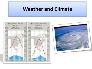
Climographs • This graph has one horizontal axis and two vertical axes. Winterland Temperature( o C) Precipitation (mm) 0 0 J F M A M J J A S O N D Months of the Year
In-Class Assignment • Handout: Climograph Construction and Analysis
Climograph Data: St. John’s http://www.trailcanada.com/canada/weather/
Climograph Data: Victoria http://www.trailcanada.com/canada/weather/
In-Class Assignment • Handout: Explain the Climate Conditions