Download
1 / 1
10 likes | 104 Vues
NOAA. NASA/JPL. 1 NOAA/NESDIS Center for Satellite Applications and Research Laboratory for Satellite Altimetry, College Park, MD, 20740, U.S.A. . 2 NOAA/NESDIS Office of Satellite and Product Operations Satellite Products Branch, College Park, MD, 20740, U.S.A. .

E N D
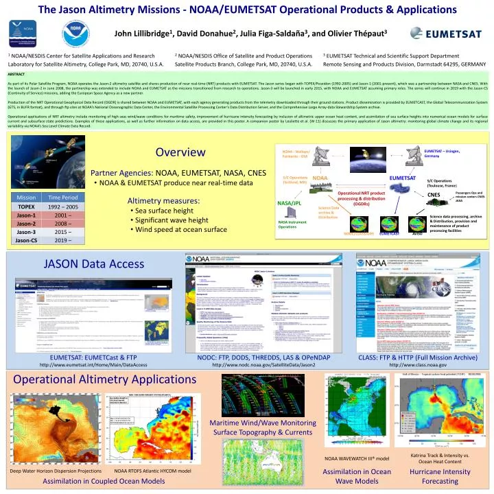
NOAA NASA/JPL • 1 NOAA/NESDIS Center for Satellite Applications and Research • Laboratory for Satellite Altimetry, College Park, MD, 20740, U.S.A. • 2 NOAA/NESDIS Office of Satellite and Product Operations • Satellite Products Branch, College Park, MD, 20740, U.S.A. • 3 EUMETSAT Technical and Scientific Support Department • Remote Sensing and Products Division, Darmstadt 64295, GERMANY ABSTRACT As part of its Polar Satellite Program, NOAA operates the Jason-2 altimetry satellite and shares production of near real-time (NRT) products with EUMETSAT. The Jason series began with TOPEX/Poseidon (1992-2005) and Jason-1 (2001-present), which was a partnership between NASA and CNES. With the launch of Jason-2 in June 2008, the partnership was extended to include NOAA and EUMETSAT as the missions transitioned from research to operations. Jason-3 will be launched in early 2015, with NOAA and EUMETSAT assuming primary roles. The series will continue in 2019 with the Jason-CS (Continuity of Service) missions, adding the European Space Agency as a new partner. Production of the NRT Operational Geophysical Data Record (OGDR) is shared between NOAA and EUMETSAT, with each agency generating products from the telemetry downloaded through their ground stations. Product dissemination is provided by EUMETCAST, the Global Telecommunication System (GTS, in BUFR format), and through ftp sites at NOAA’s National Oceanographic Data Center, the Environmental Satellite Processing Center’s Data Distribution Server, and the Comprehensive Large Array-data Stewardship System archive. Operational applications of NRT altimetry include monitoring of high seas wind/wave conditions for maritime safety, improvement of hurricane intensity forecasting by inclusion of altimetric upper ocean heat content, and assimilation of sea surface heights into numerical ocean models for surface current and subsurface state predictions. Examples of these applications, as well as further information on data access, are provided in this poster. A companion poster by Leuliette et al. (W-11) discusses the primary application of Jason altimetry: monitoring global climate change and its regional variability via NOAA’s Sea Level Climate Data Record. • Overview • Partner Agencies: NOAA, EUMETSAT, NASA, CNES • NOAA & EUMETSAT produce near real-time data • Altimetry measures: • Sea surface height • Significant wave height • Wind speed at ocean surface EUMETSAT – Usingen, Germany NOAA - Wallops/ Fairbanks - USA The Jason Altimetry Missions - NOAA/EUMETSATOperational Products & Applications EUMETSAT S/C Operations (Suitland, MD) S/C Operations (Toulouse, France) Passengers Ops and mission centers CNES- JAXA Operational NRT product processing & distribution (OGDRs) CNES Science Data archive & Distribution Science data processing, archive & Distribution, provision and maintenance of product processing facilities NASA Instrument Operations EUMETCAST AVISO NODC/CLASS/DDS • Overview JASON Data Access John Lillibridge1, David Donahue2, Julia Figa-Saldaña3, and Olivier Thépaut3 EUMETSAT: EUMETCast & FTP http://www.eumetsat.int/Home/Main/DataAccess NODC: FTP, DODS, THREDDS, LAS & OPeNDAP http://www.nodc.noaa.gov/SatelliteData/Jason2 CLASS: FTP & HTTP (Full Mission Archive) http://www.class.noaa.gov Operational Altimetry Applications Maritime Wind/Wave Monitoring Surface Topography & Currents Katrina Track & Intensity vs. Ocean Heat Content NOAA WAVEWATCH III® model Assimilation in Ocean Wave Models Hurricane Intensity Forecasting Deep Water Horizon Dispersion Projections NOAA RTOFS Atlantic HYCOM model Assimilation in Coupled Ocean Models