Download
1 / 22
220 likes | 244 Vues
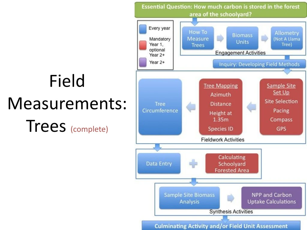
Field Measurements: Trees (complete). Field Work Concept Flow Chart. Circumference. Carbon Storage (per tree). Carbon Storage (per area). DBH. Biomass. C = D*3.14. Allometric Equations. Carbon = Biomass*45%. Land Area of Interest. Circumference. Carbon Storage (per tree).

E N D
Field Work Concept Flow Chart Circumference Carbon Storage (per tree) Carbon Storage (per area) DBH Biomass C = D*3.14 Allometric Equations Carbon = Biomass*45% Land Area of Interest
Circumference Carbon Storage (per tree) Carbon Storage (per area) DBH Biomass C = D*3.14 Allometric Equations Carbon = Biomass*45% Land Area of Interest
Field Engagement Activities • How Do Scientists Measure Trees? • Students measure tree cookies to understand the relationship between circumference and diameter • Students learn that circumference is measured at 1.35 from the tree base • Students gain understanding of concepts precision and accuracy
Circumference Carbon Storage (per tree) Carbon Storage (per area) DBH Biomass C = D*3.14 Allometric Equations Carbon = Biomass*45% Land Area of Interest
5 meter 6 meter Field Engagement Activities • Biomass Units • Students calculate the biomass of the classroom in g/m2 • Students assess how biomass would change if area or mass were different • Student rank global biomes from greatest to least biomass and compare their guess to available data • Students estimate how much carbon is stored in their in their schoolyard (g C/m2)
Circumference Carbon Storage (per tree) Carbon Storage (per area) DBH Biomass C = D*3.14 Allometric Equations Carbon = Biomass*45% Land Area of Interest
Field Engagement Activities • Understanding Allometry: Not A Llama Tree • Students measure their height and other body parts (arm span, foot length) to show how living organism’s parts are related to the whole • Students use this concept to understand how circumference/DBH can be used to estimate biomass • Students view allometric relationships of tree species
Content Question: How much carbon is being stored in the forest ecosystem near my school? Methods Development (Inquiry) What are the methods/steps required to answer each of the questions? • 1. How much carbon is stored in a given area of your schoolyard? • 2. How much of your schoolyard is covered by trees?
Sample Site Set Up 315° 45° N (0°, 360°) 15m 21.2m 30m W (270°) E (90°) S (180°) 225° 135°
By keeping track of additional information you will be later able to enter your plot into the GLOBE database so other schools can use your data (for more information about becoming a GLOBE school visit: www.globe.gov)
Tree Mapping Measure each tree as you move clockwise around the quadrant. N 15 m E 15 m
Identify each tree by species or general species group (e.g. pine, oak) • There is a basic key for New Hampshire species provided - check with your local university/cooperative extension to see if they have a key for your area • Record the species on the datasheet
Measure 1.35m from the base of the tree mark the height with a tree crayon (indelible markers) - this is “breast height” • Follow measurement guidelines from USDA Forest Service • Measure tree circumference at the given height and record on datasheet
Data Entry & Analysis • Students enter and discuss field data • Students use field data and allometric equations to calculate: plot biomass, biomass in g/m2 and carbon storage in gC/m2 • Students compare differences in biomass and carbon storage for different tree species and circumference sizes • Students use schoolyard forested area and carbon storage in gC/m2 to estimate total schoolyard carbon storage • Students perform a field unit concept assessment
Circumference Carbon Storage (per tree) Carbon Storage (per area) DBH Biomass C = D*3.14 Allometric Equations Carbon = Biomass*45% Land Area of Interest
Scaling: Finding Schoolyard Area • Students use various methods to calculate schoolyard forested area • Map & grid • GIS • Analyzing Digital Images from Digital Earth Watch
Making it meaningful… • How would schoolyard carbon storage change if… • Trees were cleared to put in a parking lot? • Trees were cleared to make a new sports field? • Trees were cleared and used to make several sports equipment sheds for the school, but the area was then allowed to re-grow? • Additional trees were planted around the school courtyard, at parking lot edges, or elsewhere on school property?
Scaling up • Using your field data can you estimate carbon storage in your state, region, country? • What does a change in forest cover in your state, region, or country mean for the global carbon cycle?
Extensions (Student Research & Project Ideas) • How would schoolyard carbon storage change… • over time as the forest moves through natural stages of succession? • if pollutants such as tropospheric ozone, acid rain or nitrogen deposition become more prevalent? • if climate change increases temperature and/or increases/decreases precipitation?
Field Measurements Coming soon… • Urban Tree Carbon Storage (Final Edits) • Piloted with Los Angeles teachers spring 2010 • Basic database of international tree equations (Current Development) • Grasslands Measurements (In progress) • To be modified from Landcover Protocols • Shrublands Measurements (Coming Soon)