Download
1 / 18
180 likes | 351 Vues
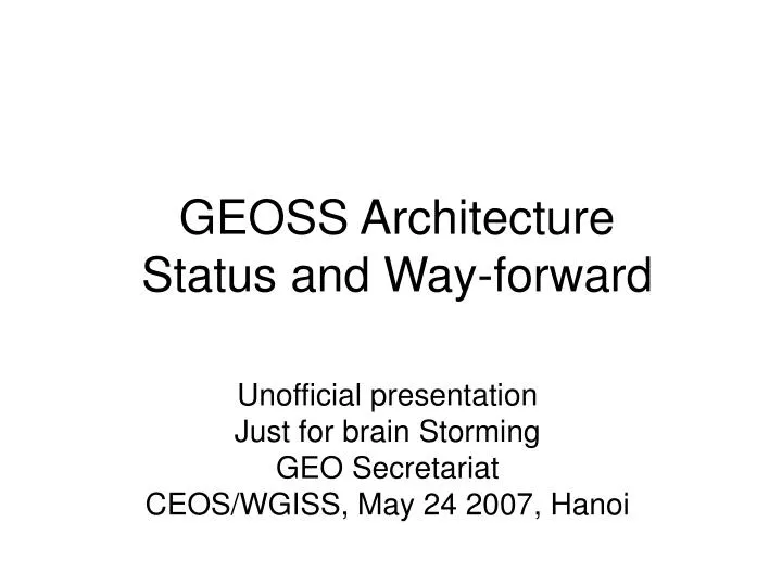
GEOSS Architecture Status and Way-forward. Unofficial presentation Just for brain Storming GEO Secretariat CEOS/WGISS, May 24 2007, Hanoi. GEO Status. Membership 69 Member Countries and European Commission 46 Participating Organizations

E N D
GEOSS ArchitectureStatus andWay-forward Unofficial presentation Just for brain Storming GEO Secretariat CEOS/WGISS, May 24 2007, Hanoi
GEO Status • Membership • 69 Member Countries and European Commission • 46 Participating Organizations • Concentrate the activities to Ministerial Summit in Nov. 30 in Cape Town, South Africa • Preparatory Task Forces have formed for Declaration, Report on Progress, Communication and Logistics • Demonstration (e.g., Video), Exhibitions • Near term schedule for Summit • Report on Progress Task Force meeting: June 4-5 • GEO Committee Co-Chairs meeting: June 6 • Communication Task Force meeting: June13 • GEO Executive committee: July 3-4 • One more iteration would be happened in September (Task Force, Executive committee) • GEO Executive committee: Nov 27 • GEO Plenary: Nov 28-29 • Ministerial Summit: Nov 30
ADC meeting • ADC-V Sept. 12-13, Washington DC area, US, chaired by I. Deloatch/USGS • with one or half day workshop of GEOSS data policy workshop organized by ICSU/CODATA • ADC-VI early Feb. 2008, Europe, Ispra, chaired by A. Annoni/EC • ADC-VII May-early June 2008, Asia, chaired by R. Shibasaki/Japan • ADC-VIII September 2008, America, chaired by J. Pearlman/IEEE
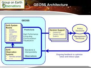
GEOSS Technical Architecture (Not Official) GEO Information System Users of 9SBAs GEO Web Portal GEONETCast Data Access and Dissemination GEOSS Clearinghouse Uplink Center Data Center Information system Data Center Information system Data Center Information system ... Data Management Model/Integration Model/Integration Data Archives Satellite Obs Systems In-Situ Obs Systems Airborne Obs Systems CEOS CGMS GOS Argo HARON FluxTower Various FDSN Commercial Others Others
Two Core Architecture Tasks AR-07-01 activities GEOSS Requirements - 10YIP - CoP Guidelines and Processes • AR-07-01 (Enabling Deployment of a GEOSS Architecture) • AR-07-02 (GEOSS Architecture Implementation Pilot) Input Strategic and Tactical Guidance Documents Japan Process for Interoperability Arrangement Component Registration Process IEEE ADC Refer/Register Component Linking Guideline Spatial Data Infrastructure ADC GSDI System of Systems Activities Standard Interoperability Forum IEEE IEEE Utilize as test cases Apply Component registration GEO M&POs Interoperability Process Pilot Projects (IPPP) Participate IEEE Access IPPP data ?? OGC AR-07-02 GEO Web Portal, GEOSS Clearinghouse and Services Participate
GEOmembersPO Identifier title contact onlineRef title description standardsOrg standardType URN status Standards serviceAbbrev serviceInfo (URL) latLongBox timePeriod agreement implementationRef ServiceInstance componentAbbrev componentContact componentCategory description onLineReference SBA status Component title description standardType contact status Special Arrangements Registries Hosted by GEOSec Hosted by IEEE (Partial Attribute Listing) May have service 0..* Member offers 0..* implementationReference 0..* Interoperability Arrangement Hosted by GMU (Temporary: 6-12months)
IPPP components and scenarios Ancillary GLIMS Terminus retreat Flood Risk Scenario Burford DEM (DEMIS) Seismic Events from Glacier/Ice Sheet Disintegration Scenario Ahern Soil moisture, stream gage, etc. GBIF CEOP Precip, soil moisture (TIGGE) Species data Precip (NCAR/TIGGE), stream gauge (CUAHSI /USGS) Climate data (NCAR) WIS Fault Lubrication Scenario Ahern Species Response to Climate Change Scenario Nativi Precip, soil moisture (TIGGE) Exotic event catalog Event catalog Landslide Risk Scenario Thomas FDSN Meningitis Early Warning System Kelly Seismic Trigger
Architecture Implementation Pilot (CFP) • Pilot for GEO Web Portal, GEOSS Clearinghouse and Services
The proposed idea of GEO Web Portal by Secretariat A Portal to DATA and SERVICES Search by location About GEO Search by theme Disaster Health Energy Climate Water Weather Ecosystem Agriculture Biodiversity Capacity Building Direct Access To Data & Services GEONETCast
Current Status of GEOSS Architecture • GEOSS Processes have been established • component registration process, process for reaching GEOSS interoperability, component linking guideline • Strategic and Tactical guidance documents would be essential but still in drafting • Requirement driven ? • Engineering view point Focus on the process • Where is the requirement? • 10 Year Implementation Plan + Reference Document • UIC Community of Practice, = subset of 10YIP, Reference Document? • Tactical guidance + Roadmap should be established based on the requirement • Test cases and scenarios would be useful
How to look the real world? - Monitor by using the GEOSS Roadmap - 3 hourly global precipitation Plan water quality monitoring GEOSS IP Targets - Water 2006-2007 2008-2011 2012-2015 Planning Prototyping Operational Space-based observation GPM & Missions for surface & subsurface water stores Study capabilities for: - surface water quality- streamflow and water storage (altimeters) Gravity mission for ground water stores Improve existing in-situ sys In-situ observation Plan integrated in-situ network Test global net of integrated in-situ sites Make integrated in-situ obs site operational Int’l coord. mechanisms Water level data collection sys Operational integrated data system Integration Implementation plan for data integration system Test a fully integrated prototype data system with assimilation, analysis & visualisation System for monitoring WC changes Routine watershed health indicators New products for precipitation, soil moisture, evaporation and evapotranspiration Integrated precip. and soil moisture products (IGOS-P) Data and info on water quantity and qualityto protoype expert decision support sys Product Integrated water cycle data sets Integrated info on climate indices/ extreme events Model Framework for ensemble hydro prediction User IF Collaborative mechanism between obs and research community
Global/Regional/National, Programs dimension • Global: example components are WIS, FDSN, GBIF, Argo • Regional: example components are HMA, Sentinel Asia • National: many… • Enhanced Observing Programs: CEOP, IPY, … • We may need to classify these components one by one?
How to look the real world? Capacity Building By CEOS/WGEdu • How each organization to cover the GEOSS Architecture. • For example, “CEOS” world as one of Participating Organizations ESA EUMETSAT Web Portal/Clearinghouse GEONETCast/Uplink Center NASA ESA JAXA USGS CNES NOAA etc CEOS/WGISS CEOS/WGCV Data Center/Information System Data Archive Satellite Observing Systems CEOS/SIT
How to look the real world? • How each organization to cover the GEOSS Architecture. • For example, EEA and UNEP, as a Participating Organization for In-situ network. Capacity Building By EEA, UNEP EEA, UNEP GEONETCast/Uplink Center Web Portal/Clearinghouse Data Center/Information System Data Archive In-situ Network Satellite Observing Systems
How to look the real world? • How each organization to cover the GEOSS Architecture. • For example, EC, as a Member. Capacity Building By FP GMES, FP GEONETCast/Uplink Center Web Portal/Clearinghouse Data Center/Information System Data Archive In-situ Network Satellite Observing Systems
How to look the real world? • How each organization to cover the GEOSS Architecture. • For example, China, as a Member. Capacity Building By National Program? GEONETCast/Uplink Center Web Portal/Clearinghouse Data Center/Information System Data Archive In-situ Network Satellite Observing Systems
Way-forward • Near term: for the Ministerial Summit in November • GEO Web Portal and GEOSS Clearinghouse • Interoperable Information Systems • Registration process should start soon • What to show? Registries? + Use Cases? (discussed in ADC) • How to show? Through GEO Web Portal? (discussed in Outreach team) • Long term: • Establish and refine the Strategic and Tactical Guidance documents • Refine the processes (component registration, etc) • Establish the sustainability of the Registry operation by the GEO Secretariat and monitoring the status • System of Systems approach would be needed • Currently Architecture has only two years targets. It would be necessary the 6 and 10 years targets.