Download
1 / 23
230 likes | 370 Vues
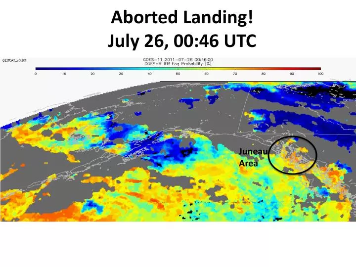
Aborted Landing! July 26, 00:46 UTC. Juneau Area. Marco Fulle - www.stromboli.net. The GOES-R AWG Fog/ L ow Cloud, Cloud Type, and Volcanic Ash Products. Mike Pavolonis (NOAA/NESDIS) Justin Sieglaff (UW-CIMSS) Corey Calvert (UW-CIMSS). High Latitude Testbed.

E N D
Aborted Landing! July 26, 00:46 UTC Juneau Area
Marco Fulle - www.stromboli.net The GOES-R AWG Fog/Low Cloud, Cloud Type, and Volcanic Ash Products Mike Pavolonis (NOAA/NESDIS) Justin Sieglaff (UW-CIMSS) Corey Calvert (UW-CIMSS)
High Latitude Testbed All processing is currently being performed at UW-CIMSS. We would like to transition the processing to GINA in order to reduce latency.
August 9, 2008 12:45 UTC Examples - Kasatochi Height (km) Height (kft) Maximum cloud height ~ 43,000 feet ASL Effective radius (microns) Mass loading (ton / km2)
IFR Probability MVFR Probability Cloud Type FLS Depth
Arctic Ocean Areas of interest Barrow Deadhorse Kaktovik MVFR Probability
Arctic Ocean Barrow Surface observation at Barrow (in middle of an FLS deck) shows VFR conditions, while further east along the Arctic Ocean coast LIFR conditions are being reported Kaktovik Deadhorse
Barrow Notice how the traditional BTD FLS product would show the same signal (color) for both Barrow, Deadhorse, and Kaktovik Kaktovik Deadhorse
MVFR Probability Barrow The GOES-R MVFR probability product indicates a < 50% probability of MVFR at Barrow and a > 50% probability of MVFR at Deadhorse and Kaktovik. In general, the GOES-R product is more sensitive than the BTD to localized changes in ceiling. Kaktovik Deadhorse
Barrow The GOES-R cloud type product indicates that supercooled liquid water clouds are present over Barrow and pockets of supercooled liquid water can be found near Deadhorse and Kaktovik. Supercooled liquid water clouds can cause aircraft icing. Kaktovik Deadhorse
Aqua-MODIS (July 05, 2010, 22:25 UTC) • Icing reports are denoted by the filled circles. • All pilot reported occurrences of aircraft icing are coincident with supercooled liquid water or mixed phase clouds.
July 20, 2011 (20:52 UTC) MVFR Probability IFR Probability Location of higher MVFR and IFR probability agree well with surface observations of ceiling
July 20, 2011 (20:52 UTC) Cloud Type GOES Visible Image It is difficult to infer MVFR and IFR conditions (away from surface observations) just using GOES visible imagery.
July 20, 2011 (06:32 UTC) The MVFR probabilities are 80-100% near surface observations of MVFR or lower ceilings, while the MVFR probability is < 50% near surface observations of VFR ceilings. The only 2 observations of IFR ceilings are co-located with IFR probabilities of 70-80%, while all other surface are co-located with with IFR probabilities of < 55%
If interested, the GOES-R fog/low cloud and cloud type products are also available from GOES (albeit with a slightly reduced accuracy compared to MODIS). Cloud Type IFR Probability MVFR Probability http://cimss.ssec.wisc.edu/geocat
Pacific Testbed The Pacific testbed has not started yet. Eventually GOES Imager volcanic ash products can be made available (if desired). *Need to gain access to near real-time MODIS data over Pacific Region
MVFR Probability IFR Probability Cloud Type GOES FLS and cloud type products for Pacific Region are also available, if interested
Near-Term Improvements • A high resolution (1 km) terrain map will be used to help detect areas where terrain rises into elevated liquid cloud layers thus creating localized MVFR/IFR conditions and to improve MVFR and IFR characterization in smaller-scale valleys. • Additional blending of satellite and NWP will be used to create “all weather” MVFR and IFR probability products (e.g. mitigate overlapping cloud limitation) • Incorporate auto-alert quality probabilistic ash detection algorithm (being developed under GOES-R3) • Probabilistic SO2 detection
Eyjafjallajökull Only (SEVIRI) • Comparisons to CALIOP indicate that the ash cloud top height estimates are biased low, as expected. • Infrared retrievals performed at large view angles have a smaller bias All Other Cases (MODIS) Nearly all of these observations are of the distal volcanic ash cloud
Cloud Type Validation Cloud Phase Accuracy Cloud Type Accuracy
FLS Validation • Objective comparison against surface observations of ceiling and LIDAR measurements of ceiling indicate that the maximum accuracy of the MVFR detection is 81 and 90%, respectively. Surface Observation Validation LIDAR Validation Day (75%) Night (83%) Combined (81%)