Download
1 / 44
450 likes | 593 Vues
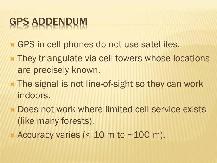
GPS in cell phones do not use satellites. They triangulate via cell towers whose locations are precisely known. The signal is not line-of-sight so they can work indoors. Does not work where limited cell service exists (like many forests). Accuracy varies (< 10 m to ~100 m). GPS addendum.

E N D
GPS in cell phones do not use satellites. They triangulate via cell towers whose locations are precisely known. The signal is not line-of-sight so they can work indoors. Does not work where limited cell service exists (like many forests). Accuracy varies (< 10 m to ~100 m). GPS addendum
What is a GIS? A GIS is a computer system capable of capturing, storing, analyzing, and displaying geographically referenced information; that is, data identified according to location. Practitioners also define a GIS as including the procedures, operating personnel, and spatial data that go into the system. From USGS
What is GIS? (from ESRI) A geographic information system (GIS) integrates hardware, software, and data for capturing, managing, analyzing, and displaying all forms of geographically referenced information. GIS allows us to view, understand, question, interpret, and visualize data in many ways that reveal relationships, patterns, and trends in the form of maps, globes, reports, and charts. A GIS helps you answer questions and solve problems by looking at your data in a way that is quickly understood and easily shared. GIS technology can be integrated into any enterprise information system framework.
Data capture How can a GIS use the information in a map? If the data to be used are not already in digital form, that is, in a form the computer can recognize, various techniques can capture the information. Maps can be digitized by hand-tracing with a computer mouse on the screen or on a digitizing tablet to collect the coordinates of features. Electronic scanners can also convert maps to digits. Coordinates from Global Positioning System (GPS) receivers can also be uploaded into a GIS.
Locations • Attributes – database about each location • GIGO • Spatial Relationships between locations (topology) Geographic Information
Vector Data Point Features +2 +3 +4 +1
Vector Data Line Features Vector of coordinate pairs
Vector Data Area (Polygon) Features Vector of coordinate pairs that start and end with the same coordinate pair
Points • Trees • Sample plots • etc • Lines • Streams • Roads • etc • Polygons • Boundary • Soil types • etc Vector data Database associated with all data (vector and raster) includes attributes about these points, lines and polygons or grid points. What types of attributes can you imagine?
Raster versus Vector Uniform cell grid representing proportional ground area Points, lines, or polygonal areas DISCUSSION POINTS Scaling/pixelation Stairstep effect Data size/complexity
Raster – The Storage Space/Resolution Tradeoff Decreasing the Cell Size by one-half causes a Four-fold increase in the storage space required
Characteristics Can be Precise Defined by cell size Positional Precision Attribute Precision Poor for continuous data Good for continuous data Analytical Capabilities Good for spatial query, adjacency, area, shape analyses. Poor for continuous data. Slower overlays. Spatial query more difficult, good for local neighborhoods, continuous variable modeling. Rapid overlays. Data Structures Storage Requirements Often complex Often quite simple Coordinate conversion Network Analyses Relatively small Often quite large Output Quality Usually well-supported Often difficult, slow Easily handled Often difficult Very good, map like Fair to poor - aliasing Comparisons, raster v.s. vector Vector Raster
Vector-Raster Conversions Effects of Resolution on Grid representation of Polygon data
Vector-Raster Conversions Grid representation of Point data
Vector-Raster Conversions Grid representation of Line data
capturing, storing, analyzing, and displaying • Data Capture • Store attributes in database • Edit shapes or attributes • Analysis • queries • geoprocessing (extraction, overlays, proximity) • Display • Output GIS Operations
The Geodatabase View GIS dataset – geographic representation Vector data: Points, Lines, Polygons
The Geodatabase View GIS dataset – geographic representation Raster (grid cell) data or images
The Geodatabase View GIS dataset – geographic representation Networks
The Geodatabase View GIS dataset – geographic representation Terrains and other surfaces
The Geodatabase View GIS dataset – geographic representation Survey measurements
The Geodatabase View GIS dataset – geographic representation Other data types, such as addresses, place names…
The Geodatabase View GIS dataset – descriptive attributes
Spatial data representation (Map layers…) Non-spatial data representation (Attribute tables…) Spatial vs. Non-Spatial Representations
The connection between spatial and non-spatial data are made through database tables Spatial vs. Non-Spatial Data
Spatial vs. Non-spatial Queries • Spatial queries: require a spatial analysis (e.g. proximity, distance, intersection…) • Non-spatial queries: are database lookup operations (e.g. locate all hemlock forest cover types…) Both types of queries will produce a map!
Spatial vs. Non-spatial Queries State adjacent to Kentucky State = Kentucky
Another skill that takes many hours to acquire and master. If you master GIS – you have a career if you want it. Next week – Hands-on exercise GIS
ARCGIS 10 FREE TRAINING