Download
1 / 52
520 likes | 521 Vues
Learn about the first state to secede from the United States and the events leading up to the American Civil War. Explore secession vocabulary and key figures like John Brown, Abraham Lincoln, and James Buchanan.

E N D
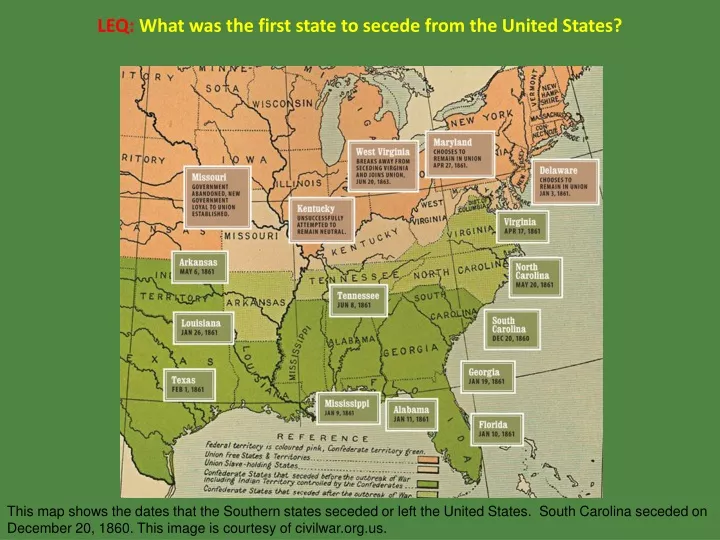
LEQ:What was the first state to secede from the United States? This map shows the dates that the Southern states seceded or left the United States. South Carolina seceded on December 20, 1860. This image is courtesy of civilwar.org.us.
LEQ:What was the first state to secede from the United States?South Carolina This map shows the dates that the Southern states seceded or left the United States. South Carolina seceded on December 20, 1860. This image is courtesy of civilwar.org.us.
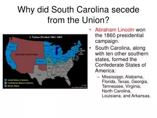
Secession Basics There were four candidates for the Presidential Election of 1860. On the left, Abraham Lincoln and Stephen A. Douglas tear at the western part of the country. John C. Breckinridge tears away the South. John Bell attempts to repair the northeastern section of the country. This image has been labeled by some editors as “Dividing the National Map.” This image is courtesy of the Library of Congress.
SecessionVocabulary This image is from wordinfo.info.
A government offer of free land to western settlers in 1862. Southern lawmakers did not approve the Homestead Act in the 1850s because they felt that many small farmers would upset the possibility of large slave holding plantations in the West. This image is courtesy of archives.gov.
Homestead ActA government offer of free land to western settlers in 1862. Southern lawmakers did not approve the Homestead Act in the 1850s because they felt that many small farmers would upset the possibility of large slave holding plantations in the West. This image is courtesy of archives.gov.
The Homestead Act gave free land to anyone who built a dwelling, improved the land, and lived on it for five years. If applicants wished to obtain title to their land before the five years was up, they could live on the land for a minimum of six months, and then purchase it for only $1.25 an acre. This image is courtesy wsj.com.
A place or dwelling where arms and military equipment are stored. This image shows the United States Armory at Harpers Ferry, Virginia (now West Virginia). This image is courtesy of sonofthesouth.net.
ArmoryA place or dwelling where arms and military equipment are stored. This image shows the United States Armory at Harpers Ferry, Virginia (now West Virginia). This image is courtesy of sonofthesouth.net.
In 1859 abolitionist John Brown hoped to seize the armory at Harpers Ferry, and to use the weapons captured there to free southern slaves. Brown and his men planned to escape with the weapons into the mountains and they expected slaves from around the South to join them. These weapons are on display at the John Brown Exhibit at Harpers Ferry National Historic Park. This image was taken by Robert Housch on April 27, 2014.
The American Civil War Begins People to Meet This depicts individuals who were involved with John Brown’s Raid on Harpers Ferry, Virginia (now West Virginia). This image is on display at the John Brown Exhibit at Harpers Ferry National Historic Park in a section titled “Who Was Who.” A photograph of the image was taken by Robert Housch on April 27, 2014.
Abolitionist who hoped to seize the armory at Harpers Ferry, and to use the weapons captured there to free southern slaves. When John Brown came to Virginia, he was almost 60 years old. This photograph was taken by Martin M. Lawrence (1808-1859). A woodcut of this photograph appeared in the November 19, 1859 edition of Frank Leslie’s Illustrated Newspaper. This image is on display at the John Brown exhibit at Harpers Ferry National Historic Park. A photograph of this image was taken by Robert Housch on April 27, 2014.
John BrownAbolitionist who hoped to seize the armory at Harpers Ferry, and to use the weapons captured there to free southern slaves. When John Brown came to Virginia, he was almost 60 years old. This photograph was taken by Martin M. Lawrence (1808-1859). A woodcut of this photograph appeared in the November 19, 1859 edition of Frank Leslie’s Illustrated Newspaper. This image is on display at the John Brown exhibit at Harpers Ferry National Historic Park. A photograph of this image was taken by Robert Housch on April 27, 2014.
United States Army Colonel who was sent to Harpers Ferry, Virginia (now West Virginia) to end John Brown’s raid. This image shows Robert E. Lee (1807-1870) when he was a brevet Lieutenant-Colonel of Engineers in 1850. This image was taken by Mathew Brady (1822-1896). This image is courtesy of Wikimedia Commons.
Robert E. LeeUnited States Army Colonel who was sent to Harpers Ferry, Virginia (now West Virginia) to end John Brown’s raid. This image shows Robert E. Lee (1807-1870) when he was a brevet Lieutenant-Colonel of Engineers in 1850. This image was taken by Mathew Brady (1822-1896). This image is courtesy of Wikimedia Commons.
The President of the United States during John Brown’s Raid, during the 1860 election, and during the secession of the first seven southern states. James Buchanan (1791-1868) is the only President of the United States from the Commonwealth of Pennsylvania. This portrait was created by George Peter Alexander Healy (1818-1894) in 1859. This image is courtesy of the National Portrait Gallery and of Wikimedia Commons.
James Buchanan The President of the United States during John Brown’s Raid, during the 1860 election, and during the secession of the first seven southern states. James Buchanan (1791-1868) is the only President of the United States from the Commonwealth of Pennsylvania. This portrait was created by George Peter Alexander Healy (1818-1894) in 1859. This image is courtesy of the National Portrait Gallery and of Wikimedia Commons.
Illinois Senator who ran for President in 1860 as the nominee for the Northerners in the Democratic Party. Stephen Arnold Douglas (1813-1861) ran against Abraham Lincoln for Senator from Illinois in 1858, and as President of the United States in 1860. He was nicknamed “The Little Giant.” This image was created by Mathew Brady circa 1860. This image is courtesy of the National Archives and of Wikimedia Commons.
Stephen A. Douglas Illinois Senator who ran for President in 1860 as the nominee for the Northerners in the Democratic Party. Stephen Arnold Douglas (1813-1861) ran against Abraham Lincoln for Senator from Illinois in 1858, and as President of the United States in 1860. He was nicknamed “The Little Giant.” This image was created by Mathew Brady circa 1860. This image is courtesy of the National Archives and of Wikimedia Commons.
Kentuckian who as Vice President under James Buchanan ran for President in 1860 as the nominee for the Southerners in the Democratic Party. John C. Breckinridge during the American Civil War was a Major General in the Confederate States Army. This image was taken by Mathew Brady (1822-1896) circa the 1860s. This image is courtesy of the Library of Congress.
John C. Breckinridge Kentuckian who as Vice President under James Buchanan ran for President in 1860 as the nominee for the Southerners in the Democratic Party. John C. Breckinridge during the American Civil War was a Major General in the Confederate States Army. This image was taken by Mathew Brady (1822-1896) circa the 1860s. This image is courtesy of the Library of Congress.
Former Tennessee Senator who ran for President in 1860 as the nominee for the Constitutional Union Party which took a “neutral stand” on slavery. John Bell (1796-1869) was speaker of the United States House of Representatives (1834-1835) and briefly served as William Henry Harrison’s Secretary of War in 1841. This image was taken by Mathew Brady (1822-1896) circa the 1850. This image is courtesy of the Library of Congress.
John Bell Former Tennessee Senator who ran for President in 1860 as the nominee for the Constitutional Union Party which took a “neutral stand” on slavery. John Bell (1796-1869) was speaker of the United States House of Representatives (1834-1835) and briefly served as William Henry Harrison’s Secretary of War in 1841. This image was taken by Mathew Brady (1822-1896) circa the 1850. This image is courtesy of the Library of Congress.
Attorney from Springfield, Illinois who won the 1860 Presidential Election. Although Lincoln opposed extending slavery into the territories, he conceded Southerners’ right to have slavery in the South. Lincoln became the Republican Party’s nominee for President. This image was taken in 1860 by an unknown photographer. This image is courtesy of Wikimedia Commons.
Abraham Lincoln Attorney from Springfield, Illinois who won the 1860 Presidential Election. Although Lincoln opposed extending slavery into the territories, he conceded Southerners’ right to have slavery in the South. Lincoln became the Republican Party’s nominee for President. This image was taken in 1860 by an unknown photographer. This image is courtesy of Wikimedia Commons.
Former Mississippi United States Senator who became the first and only President of the Confederate States of America. Jefferson Finis Davis (1808-1889) was born in Kentucky, was a graduate of the United States Military Academy at West Point, and served in the Mexican American War. He was Secretary of War under Franklin Pierce. This image was taken by Mathew Brady (1822-1896) circa 1861. This image is courtesy of the Library of Congress.
Jefferson Davis Former Mississippi United States Senator who became the first and only President of the Confederate States of America. Jefferson Finis Davis (1808-1889) was born in Kentucky, was a graduate of the United States Military Academy at West Point, and served in the Mexican American War. He was Secretary of War under Franklin Pierce. This image was taken by Mathew Brady (1822-1896) circa 1861. This image is courtesy of the Library of Congress.
The American Civil War Begins Maps This map shows the first southern states to secede in dark red. The last four southern states to secede in bright red, the border states in yellow, and the states that remained in the United States in blue. This image is courtesy of Wikimedia Commons.
Harpers Ferry, Virginia (now West Virginia)Find Harpers Ferry on this map of the 50 States of the United States. This image shows the 50 States of the United States. This image is courtesy of the University of Texas.
Harpers Ferry, Virginia (now West Virginia)Find Harpers Ferry on this map of the 50 States of the United States. Harpers Ferry is now labeled with a red dot and the words “Harpers Ferry.” This image shows the 50 States of the United States. This image is courtesy of the University of Texas.
Washington, D.C.Find Washington, D.C. on this map of the current United States. This map shows the present boundaries of the states. The image is courtesy of the University of Texas.
Washington, D.C.Find Washington, D.C. on this map of the current United States. Washington, D.C. is now marked by a red dot and the words “Washington, D.C.” The image is courtesy of the University of Texas.
Charleston, South CarolinaFind Charleston, South Carolina on this map of the current United States. This map shows the present boundaries of the states. The image is courtesy of the University of Texas.
Charleston, South CarolinaFind Charleston, South Carolina on this map of the current United States. Charleston, South Carolina is now marked by a red dot and the word “Charleston.” This map shows the present boundaries of the states. The image is courtesy of the University of Texas.
Montgomery, AlabamaFind Montgomery, Alabama on this map of the current United States. This map shows the present boundaries of the states. The image is courtesy of the University of Texas.
Montgomery, AlabamaFind Montgomery, Alabama on this map of the current United States. Montgomery, Alabama is now marked by a red dot and the word “Montgomery.” The image is courtesy of the University of Texas.
South CarolinaFind South Carolina on this map of the current United States. This map shows the present boundaries of the states. The image is courtesy of the University of Texas.
South CarolinaFind South Carolina on this map of the current United States. South Carolina is now colored red. The image is courtesy of the University of Texas.
MississippiFind Mississippi on this map of the current United States. This map shows the present boundaries of the states. The image is courtesy of the University of Texas.
MississippiFind Mississippi on this map of the current United States. Mississippi is now colored red. The image is courtesy of the University of Texas.
FloridaFind Florida on this map of the current United States. This map shows the present boundaries of the states. The image is courtesy of the University of Texas.
FloridaFind Florida on this map of the current United States. Florida is now colored red. The image is courtesy of the University of Texas.
AlabamaFind Alabama on this map of the current United States. This map shows the present boundaries of the states. The image is courtesy of the University of Texas.
AlabamaFind Alabama on this map of the current United States. Alabama is now colored red. The image is courtesy of the University of Texas.
GeorgiaFind Georgia on this map of the current United States. This map shows the present boundaries of the states. The image is courtesy of the University of Texas.
GeorgiaFind Georgia on this map of the current United States. Georgia is now colored red. The image is courtesy of the University of Texas.
LouisianaFind Louisiana on this map of the current United States. This map shows the present boundaries of the states. The image is courtesy of the University of Texas.
LouisianaFind Louisiana on this map of the current United States. Louisiana is now colored red. The image is courtesy of the University of Texas.
TexasFind Texas on this map of the current United States. This map shows the present boundaries of the states. The image is courtesy of the University of Texas.
TexasFind Texas on this map of the current United States. Texas is now colored red. The image is courtesy of the University of Texas.