Download
1 / 17
170 likes | 332 Vues
http://almandine.geol.wwu.edu/~dave/courses/2003/spring/101/lectures/water_level.swf.

E N D
http://almandine.geol.wwu.edu/~dave/courses/2003/spring/101/lectures/water_level.swfhttp://almandine.geol.wwu.edu/~dave/courses/2003/spring/101/lectures/water_level.swf • In the low permeability case the water is pumped primarily from the area directly around the well, whereas with the higher permeability the water seems to be drawn from a more broad area surrounding the well "hole". Since permeability refers to the ability of a material to let a fluid move through it, the low permeability doesn't allow the water to venture far from the path of pressure change (the "hole" of the well).
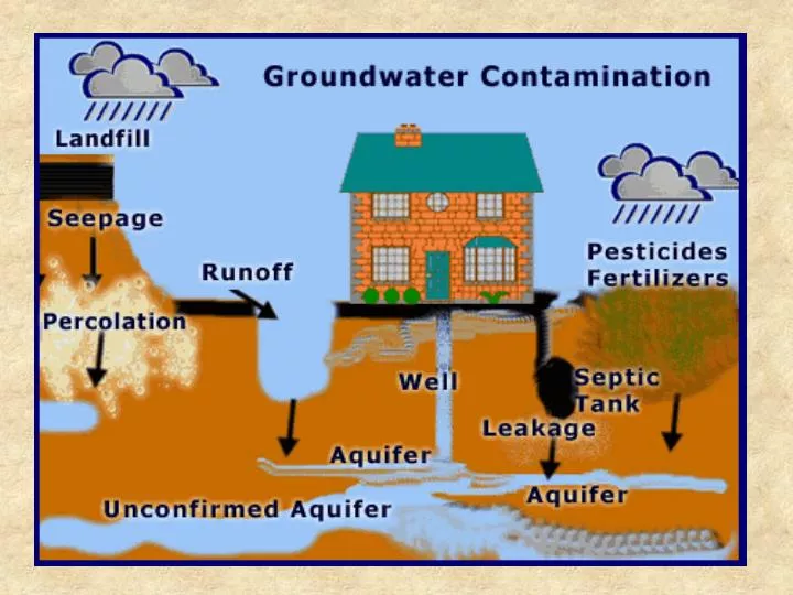
Groundwater Flow • Groundwater velocity • Depends on permeability and hydraulic gradient (slope of water table) • Ranges from 100 m/day to mm/day • A good round number: 1 ft/day • Groundwater pollution is a function of the type of contaminant and the medium into which it is found.
Back to the Civil Action Case… Could the contaminants in the water have come from the named polluters and reached wells G & H prior to 1979?
Legend: H = municipal well H G = municipal well G U = Unifirst Properties G = W.R. Grace B = Beatrice (Riley Tannery) red = outcrop of fractured schist pink (Qgm) = ground moraine (mixtures of sand-silt-clay) beige with blue plant symbols (Qsd) = wetland deposits (mixtures of peat-sand-silt) white (Qo) = glacial outwash (mixtures of sand and gravel with silt) yellow (Qf) = artificial fill
This geologic cross-section is much more detailed than what is expected from the assignment, however…
Groundwater flow is perpendicular to the water-table contours.
Area is introduced into the equation to determine discharge. The slope of the groundwatertable is equal to the change in elevation between two reference points on the water table divided by the horizontal distance between these reference points. Darcy’s Law relates the velocity of groundwater flow to the slope of the water table (hydraulic head) and the hydraulic conductivity (permeability). Darcy’s Law can be written mathematically where: Velocity of groundwater flow = hydraulic conductivity x hydraulic gradient.