Download
1 / 23
230 likes | 405 Vues
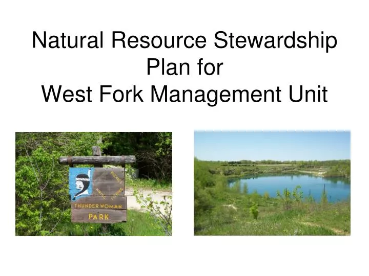
Natural Resource Stewardship Plan for West Fork Management Unit. The West Fork Management Unit is comprised of the following areas: Thunderwoman Park Turkey Ridge Wildlife Area West Fork Access Fisher Forest Shell Rock Access Flood buyout properties in Finchford.

E N D
Natural Resource Stewardship Plan forWest Fork Management Unit
The West Fork Management Unit is comprised of the following areas: • Thunderwoman Park • Turkey Ridge Wildlife Area • West Fork Access • Fisher Forest • Shell Rock Access • Flood buyout properties in Finchford
Description of West Fork Unit • Located in northwest corner of county near Finchford and Janesville. • Encompasses approx. 575.28 acres of public ground. • Located along the West Fork of Cedar River and also Shell Rock River. • Primarily floodplain forest except for Turkey Ridge Wildlife Area which contains upland prairie and timber. • Contains features such as an old quarry pond, primitive tent camping, steel suspension bridge, and flood buyouts parcels.
Thunderwoman Park as seen in 1930’s Iowa Geographic Map Server, ISU
5 primary factors emphasizing the need • for a NRSP: • Provide overall “picture” of the unit and to develop a “road map” for future management decisions. • The decline of Species of Greatest Conservation Need (SGCN) and common species. • Loss of habitat diversity and associated wildlife. • The loss of early successional forest stands and associated wildlife. • Public access availability for recreation purposes.
Primary Objectives of West Fork Plan • Objectives aim to address biodiversity, water quality and outdoor recreation. • Create and maintain a high diversity of habitat types for a variety of wildlife species including SGCN. (Wood Turtle) • Create large habitat blocks • Increase recreational opportunities and public access • Form partnerships to achieve objectives • On a state-wide basis, these objectives mirror current plans such as the Iowa • Wildlife Action Plan (IWAP) and Statewide Comprehensive Outdoor Recreation • Plan (SCORP) and locally the REAP and BHCCB Pathway plan.
Management Systems of West Fork Unit • Prairie/Grassland • Forest – (Upland and Floodplain) • Open Woodland/Savanna • Developed Areas • Aquatics • Flood Buyouts • Viewshed • Other
Prairie/Grassland • Comprises approx. 49 acres of the West Fork Unit • Includes NWSG (native warm season grasses) and also cool season species. • These systems provide critical habitat for grassland nesting bird species and butterflies which show a significant decline in past decades. (sedge wren, bobolink, regal fritillary, and dusted skipper) • Manage by mowing, haying, and prescribed burns. • Goals • Convert cool season to NWSG where appropriate. • Interseed forbs where necessary to diversify the prairie. • Maintain with mowing, fire, and haying on a rotational basis.
Forest • Characterized as at least 60% canopy cover with interlocking crowns. • Upland Forest – Comprises approx. 41 acres • Floodplain Forest – Comprises approx. 412 acres • Forest Management is divided into three categories: • Early Successional – high stem density (amercian woodcock, goldwing warbler) • Even Age – same age class (turkey, deer, wood ducks, salamanders) • Uneven Age – various age classes (kentucky warbler, pileated woodpecker) • Goals • Stand map West Fork Unit with Stare Forester. • Write forest management plan. • All three categories represented within the unit. Early Successional habitat
Forest Management “Each stage of a forest is utilized by wildlife. During the first 15-20 years, the stand will be used by many of the same species as an early successional stand. Whereas a 20-60 year old stand will be used by canopy nesters as well as ground nesting birds. As the stand matures in the 60-125 years old range, a final compilation of birds will be found such as the pileated woodpecker, red-shouldered hawk, and prothonotary warbler.”
Open Woodland/Savanna • Characterized as open stand of tree species with 25-60% canopy cover • Comprises approx. 7 acres of West Fork Unit • Oak trees along with herbaceous ground species typically represent this management system. • Typically managed by prescribed fire and mowing/cutting. • Long-eared owl, smooth green snake • Goals • Map areas • Disturb areas by periodic cutting, mowing, and burning to maintain open canopy.
Developed Areas • Comprises approx. 20 acres of West Fork Unit • Includes parking areas, campgrounds, shelters, boat ramps, trails, roads, and shelters. • Management includes mowing, signage, and maintenance of facilities and public accesses. • Unit Ranger along with Exec. Director and Conservation Board determines allocation of resources to maintain developed areas. • Goals • Uniform designation for all areas (wildlife area, preserve, refuge, park) • Signage reflect designations. • Boat ramp along West Fork Cedar • Close off a section of Thunderwoman Park Road near bridge.
Flood Buyouts • Comprises 6 lots totaling 29.78 acres the BHCCB will manage • Management may include mowing, neighborhood gardens, green space. • Determined on a site-by-site basis and in accordance to flood buyout regulations.
Aquatics • Comprises approx. 98 acres in the West Fork Unit • Includes main river channels, lakes, ponds, and main oxbows. • Excellent fishing, hunting, and trapping along with SGCN such as the osprey, bald eagle, wood thrush, wood turtle, and american brook lamprey. • Goals • Improve public access/recreation (fishing, hunting, kayaking, water access) • Provide “buffers” for SGCN such as wood turtle or other species. • Improve water quality with land management practices.
Viewshed • Definition - An element of the landscape which viewed from an aesthetic, biological, historical, or cultural viewpoint has inherent qualities to be preserved determined by those who view it. • These may include trails (including water trail) “right of ways,” naturally scenic bluffs/valleys, and unique wildlife habitats. • Viewsheds will be taken into consideration when planning and carrying out management recommendations in the West Fork Unit understanding that a viewshed could have many meanings for many people.
Other • Comprises approx. 17 acres in the West Fork Unit. • Characterized as heavily disturbed due to past land usage and usually contain low quality soils with little to no vegetation cover or biodiversity. • Goals: • Add soil profile and seed with native species. • Interseed prairie or tree species into existing habitat to increase diversity.
Plan Recommendations • High Priorities 1) Continue land reclamation of Turkey Ridge Wildlife Area. 2) Designation of areas (Wildlife Area, Park, Refuge, Significant Natural Area, State Preserve, Access) 3) Inventory signs and change according to designation or acquisition requirements. 4) Incorporate flood buyouts into system. 5) Boat ramp along West Fork of Cedar. 6) Close section of road through south side of Thunderwoman. Maintain parking lot at suspension bridge and water access. 7) Parking lot off Newell Rd.
Notable Info. Upland – 16% of entire unit Lowland – 84% of entire unit • Upland Forest – 7% of unit • Floodplain Forest – 76% of unit
QUESTIONS? Jim Weimer, Wildlife Conservationist Black Hawk County Conservation Board Email: jweimer@co.black-hawk.ia.us Ph: 319-433-7275