Download
1 / 15
150 likes | 352 Vues
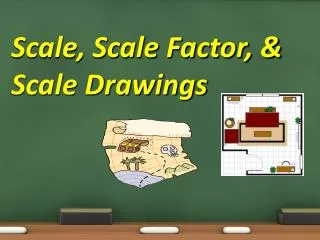
NR 322: Scale and Resolution. Jim Graham & Alex Daniels Fall 2010 Chapter 2. Scale. Scale is the scale of the map relative to the true size of the items on the map e.g 1:750,000 1 unit on the map is equivalent to 750,000 units on the earth Small scale vs Large scale Which number is larger

E N D
NR 322: Scale and Resolution Jim Graham & Alex Daniels Fall 2010 Chapter 2
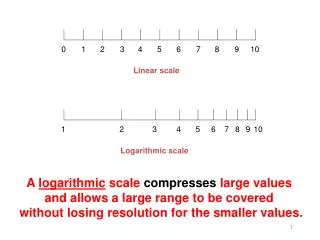
Scale • Scale is the scale of the map relative to the true size of the items on the map • e.g 1:750,000 • 1 unit on the map is equivalent to 750,000 units on the earth • Small scale vs Large scale • Which number is larger • 1 / 750,000 or 1 / 2
Misunderstood Terminology • Small Scale = Large Extent • Think of the divisions on the scale being small • Miles are smaller at small scale • Large Scale = Small Extent • Think of the divisions on the scale being big • Miles are larger at large scale • Recommendation: • Use Large Extent or Small Extent • Use Low Resolution or High Resolution
Scale can vary on a map • What is the scale in kilometers on a Geographic Projection map?
Scale can Vary • What is the scale on a google earth map?
Resolution • Resolution is the ability to resolve detail • We mostly refer to Spatial Resolution • For Rasters/Grids/Digital Photos this means the size of the pixels. • What distance on the ground does one pixel represent? 30 Meters
Resolution • High resolution is awesome, why don't we make everything 1m data or better? • The number of pixels increases exponentially as you increase spatial res. Resolution x 2 Pixels x 4
High Resolution ~ Big Files • Rasters and photos can get really big really fast. • Civilian satellites now can take satellite photos as high as 41 cm resolution • i³ in Fort Collins has 1m Satellite Photos that take 300 Gigabytes for just one area.
Low spatial resolution • Low resolution averages data
Accuracy and Precision • Accuracy is how close something is to the true value • Precision is how close of a measurement you can make • High accuracy doesn't mean high precision