Download
1 / 29
300 likes | 442 Vues
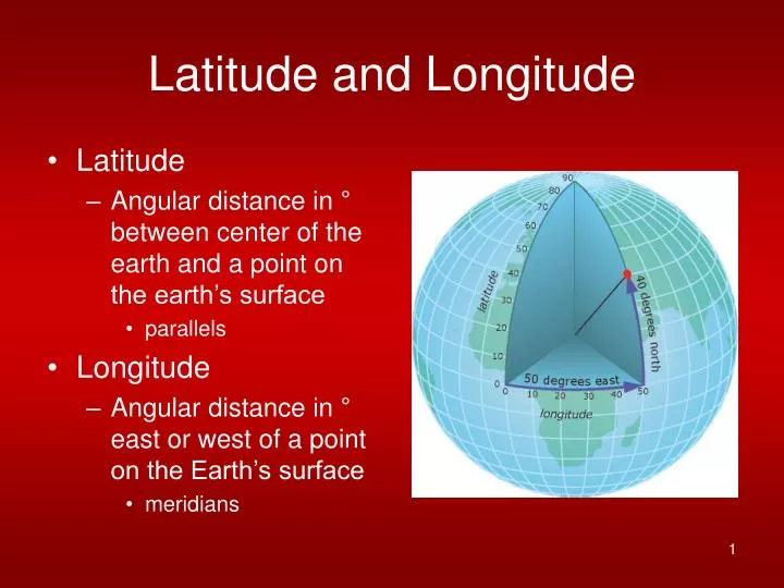
Latitude and Longitude. Latitude Angular distance in ° between center of the earth and a point on the earth’s surface parallels Longitude Angular distance in ° east or west of a point on the Earth’s surface meridians. LAT AND LONG.

E N D
Latitude and Longitude • Latitude • Angular distance in ° between center of the earth and a point on the earth’s surface • parallels • Longitude • Angular distance in ° east or west of a point on the Earth’s surface • meridians
LAT AND LONG • LATITUDE- MEASURES N AND S OF EQUATOR (0 TO 90°) BUT RUNS E AND W • LONGITUDE MEASURES E AND W OF PRIME MERIDIAN (O TO 180°) BUT RUNS N AND S
LATITUDE AND LONGITUDE 30°N EQUATOR 0° NEW ORLEANS 30°N 90°W 90° W 0°
Lat and Long Distances • Latitude • 69.13 miles (111.23 km) between each degree of latitude • Longitude • Varies by latitude • 69 miles at equator only • 59.9 miles at 30° • 34.6 miles at 60°
Lat and Long estimation • Latitude • Can be estimated using the north star (Polaris), or Southern Cross • Longitude • Very tricky • 1700’s difference between fixed clock and ship clock
International Date Line SEPARATES ONE DAY FROM THE NEXT WHERE THE NEW DAY STARTS ANY LOCATION EAST OF OUR TIME ZONE UP TO 180° E IS AHEAD OF US ANY LOCATION WEST OF US UP TO THE DATE LINE (180°) IS BEHIND US Earth’s rotational speed is approximately 15° longitude/hour So 24 time zones TIME ZONES
UTC or Z time London 5 hours ahead 6 on ST DST New DST Not in Arizona, Hawaii Indiana? Now observes DST Keeping Time
Map Projections • Graticule → flat sheet of paper • 3D to 2D • distortion in 4 main properties • major – pertains to all areas • conformality (shape) • equivalence (area & scale) • minor – pertains to only 1 or 2 points • equidistant (distance) • azimuthal (direction)
Conformality (shape) retention of correct angles requirements meridians & parallels cross at right angles misleading small areas VS large areas Equivalence (area) is lost Equivalence (area) unit area on map = same square unit on globe surface characteristics right angle crossing is lost shape distorted Shape vs Area
Minor Properties • Equidistant (distance) • measure from center • others area are incorrect (significant amount) • equivalence (area) is lost • DO NOT measure distance on a map showing a large area unless it is equidistant
Minor Properties and Other • Azimuthal (direction) • true directions from 1 central point • others inaccurate • can preserve 1 other property • Other • Compromise • does not preserve any of the 4 main properties
Map Projections • 4 general classes • planar (azimuthal) • cylindrical • Conic • oval • and miscellaneous
Planar Projections (Azimuthal) • Flat sheet of paper • @ pole – polar aspect (simplest); • least distortion • @ mid-latitude – oblique aspect; • @ equator – equatorial aspect • Azimuthal projection • air navigational • hemispheres • No (minimal) modifications
Lambert Azimuthal Equal Area • Map large ocean areas SOURCE: Peter H. Dana, Department of Geography, University of Texas at Austin, 1995
Oblique Aspect Orthographic Projection • Perspective views of hemispheres. SOURCE: Peter H. Dana, Department of Geography, University of Texas at Austin, 1995
Cylindrical Projections • Tangent to line(s) on sphere • normal @ equator • Characteristics • meridians do not converge at poles • space parallels further apart • smaller area – shape preserved • Uses • atlases • map of the world
Behrmann Cylindrical Equal-Area SOURCE: Peter H. Dana, Department of Geography, University of Texas at Austin, 1995
Peters Projection SOURCE: Peter H. Dana, Department of Geography, University of Texas at Austin, 1995
Mercator Projection • Marine navigation • rhumb line
Miller Cylindrical Projection • Avoids scale exaggerations of the Mercator • shape & area distorted • true direction along equator SOURCE: Peter H. Dana, Department of Geography, University of Texas at Austin, 1995
Conic Projections • Cone enveloped around sphere • normal – cone is tangent along a chosen parallel • Area and shape preserved • Simple Conic & Polyconic • Uses: • areas w/ east-west extent • National Atlas of the United States of America
SOURCE: Peter H. Dana, Department of Geography, University of Texas at Austin, 1995
Conic Polyconic
Albers Equal Area Conic SOURCE: Peter H. Dana, Department of Geography, University of Texas at Austin, 1995
Miscellaneous Projections • Unprojected Maps • distortion • scale, • distance, • area, & • shape • increases toward the poles
SOURCE: Peter H. Dana, Department of Geography, University of Texas at Austin, 1995 N. America: Unprojected Latitude and Longitude World: Unprojected Latitude and Longitude SOURCE: Peter H. Dana, Department of Geography, University of Texas at Austin, 1995
Choosing a Map Projection • 1st step is to determine: • location • size • shape • These 3 determine where the area to be mapped falls in relation to the projections distortion • country in the tropics – cylindrical projection • country in the temperate zone – conical projection • polar area – planar projection
Choosing a Map Projection (2) • These global zones map into the areas in each projection where distortion is lowest: • Cylindricals are true at the equator and distortion increases toward the poles. • Conics are true along some parallel somewhere between the equator and a pole and distortion increases away from this standard. • Planar are true only at their center point, but generally distortion is worst at the edge of the map. • Can make other modifications