Download
1 / 18
180 likes | 314 Vues
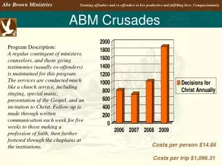
ABM February 2013. David Provis & Werner Hennecke. ABM Strategic Directions 2012-16. Promoting integrated coastal planning including responses to climate challenges Enhancing management of coastal assets and infrastructure Promoting ecological health of marine areas and the coast

E N D
ABM February 2013 David Provis & Werner Hennecke
ABM Strategic Directions 2012-16 • Promoting integrated coastal planning including responses to climate challenges • Enhancing management of coastal assets and infrastructure • Promoting ecological health of marine areas and the coast • Encouraging sustainable and equitable recreation and social uses • Enhanced understanding of economic, social and environmental values and benefits • Refining and improving our organisational approach
Promoting integrated coastal planning • Focus: • Comprehensive coastal processes and erosion mapping, hazard and risk assessment for the entire bay • Comprehensive future climate assessments and access to improved data including up-to-date flood and inundation data and detailed mapping • Consistent and effective planning policy, controls, indemnity, monitoring, tools, training and resources • Requirements: • Identify needs for good planning -> science? • High quality data collected over sufficiently long period of time • Modelling of range of hazard scenarios • Mapping of scenario outputs.
Enhancing management of coastal assets and infrastructure • Focus: • Coastal infrastructure improvements, including renewal and new works that are adaptive and innovative • Comprehensive beach nourishment approaches and cooperative erosion control measures • Drainage, sewerage and stormwater quality improvements through coordinated and integrated coastal and water management approaches • Requirements: • Understanding of (condition of) assets along the coast, ranging from natural to built and infrastructure assets, both, land and marine-based. • Strategic planning for asset maintenance • Assessment of natural (coastal & estuarine) processes affecting the coast, now and under conditions of a warmer climate with more frequent and more severe events affecting the coast • Understand process requiring beach nourishment & erosion control • Investigate if ‘cause’ can be addressed rather than the impacts
Economic, social and environmental values and benefits • Focus • Better understanding the values and pressures on coastal Crown land and protecting and enhancing these areas • Better understanding costs-benefits, value of ecosystem services, net community benefit concepts which support effective decision making • Supporting and promoting the preparation and application of detailed local plans along the coast • Supporting sustainable and safe, port and shipping related services, commercial activities, appropriate local water transport options and tourism • Requirements • Recognition of the geographic area in question (PPB) and its significance for economy and recreation • Liaison with key Crown land stakeholders and encourage cooperation and exchange of information between them • Gather sufficient understanding to prepare and apply detailed local plans
Refining and improving our organisational approach • Focus • Providing capacity-building and technical skills opportunities • Requirements • Improve skills within council • Provide and communicate effectively technical background and relevant documentation to key decision makers and technical staff (eg, Engineers Australia handbooks) • Be a source of relevant and reliable information
THIS PROJECT: Capacity Building in Local Coastal GovernmentUnderstanding physical processes shaping the coast • Aims: • Progress understanding of processes shaping coast (past and present) • Progress understanding of level of resistance of different types of coast to coastal processes • Progress understanding of potential effects of human interference • Progress understanding of potential effects of climate change • Requirements: • Understand and document key issues faced by land managers • Collate relevant available information to improve understanding of those issues • Use information to develop and employ tools to monitor and better understand present and future behavior of the coast • Capacity building and provision of technical skills in easily understandable ways
Beach processes vs. resistance of coast to processes • Onshore / offshore • Longshore • Shore rotation • Soft shoreline (sandy, muddy) • Hard shoreline (rock) • Protection / human interference
Improving our understanding of processes shaping the coast Land Ocean Change • Shore type • Hard/Soft sand • Muddy • Rocky • … Coastal processes & Response of coast (short, long-term change) • Weather/Climate • Sea level • Waves • Currents • Storms • Assets • Natural • Infrastructure • Cultural • … Durationof event • Future • More frequent • More significant • Change in pattern Data & Knowledgeto address change • Protection/Maintenance • Structure (condition) • Re-nourish (cost / frequency) • Retreat • Other …
Sediment transport • Waves meeting a beach at an angle will tend to move sediment along the beach Beach Sediment Transport Wave Direction Wave crests
Sediment transport (cont.) • When there is barrier, sediment builds up, but only to the angle of the incoming waves. Beach Sediment Transport Wave Direction Wave crests
Primary requirements • Understand processes driving change at present prior to adding complexity of uncertain future (climate change) • What are key questions / priority issues? • What information is available (past and present)? • What information is assumed NOT to be available? (information brokering by ABM with support from Cardno) • What information is clearly not available but is vital for understanding the issues and should have been collected? • Future Tasks • Develop mostly suitable option(s) to address individual issues
(Further) development of a coastal (spatial) information system • Collation of all spatial and non-spatial information in a GIS, including DSE Future Coasts data and data held by state and local government • Integration of newly collected data • Integration of models in GIS • Dissemination of information • Reports • Maps • Google Earth files
Data / Information sources • LiDAR (topographic / bathymetric) • Shoreline change (eg, surveys, LiDAR, aerial photography, oblique photos, etc.) • Beach type / sand size / profile etc. • Geology / geomorphology • Available erodible (sand) volume • Beach re-nourishment (volume, frequency) • Assets (tangible, intangible); height above projected level of impact • Low lying areas (inundation; road cut off etc.) • Protection structures incl height & condition • Weather / climate / ocean data (wind, waves, currents – seasonal, annual decadal, etc.) • Significant past events and weather conditions at the time