Download
1 / 40
430 likes | 625 Vues
Lao PDR REPORT Ninth Session of the Forum on Regional Climate Monitoring, Assessment and Prediction for Asia (FOCRAII) “ Current Status of Climate monitoring and Long - range Weather Forecast in Lao PDR 08 – 10 April 2013 Beijing, China by: Mr. Vanhdy DOUANGMALA

E N D
Lao PDR REPORT Ninth Session of the Forum on Regional Climate Monitoring, Assessment and Prediction for Asia (FOCRAII) “Current Status of Climate monitoring and Long - range Weather Forecast in Lao PDR 08 – 10 April 2013 Beijing, China by: Mr.Vanhdy DOUANGMALA Department of Meteorology and Hydrology , Lao PDR
Outline • Introduction • Current status of facilities and services • Hydro–Meteorological Network and data exchange • Natural disasters in Lao PDR • Tropical Cyclone Monitoring • Long-range weather forecast in Lao PDR
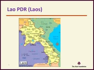
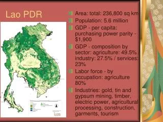
Lao PDR is located at the SE ofAsia Total areas: 236.800 Km2 Population: 5.9 million (2007’s statistics) Rural population: 69 % density: 25 people/km2 Average annual population growth rate: 2.1% Introduction • GDP per capita ( US$ , 2006) : 674 • Number of provinces : 17 • The main River is MEKONG • Length of 1. 865 kmflow through Laos • There are 13 major tributaries
The distribution of mean annual rainfall over the Lao PDR shows: the highest rainfalls of more than 3000 mm/year occur in the upper of central, also in central of southern regions. and the lowest less than 1500 mm/year localized in the northern region. Climate of Lao PDR The Rainfall Climate of Lao PDR Annual average Isohyets (1988–2007)
Current Status of Facilities and Services • MTSAT-1R • Located in headquarter • MTSAT-VIS • MTSAT-IR1 • MTSAT-IR2 • MTSAT-IR3 • MTSAT-IR4 • Renew every 30 minute • Doppler weather Radar • Located in headquarter • C-band • Intensity mode 400 km • Doppler mode 120 km
Doppler Weather RADAR 8th Floor 6th Floor Equipment:Operation, Control & Maintenance Observation & Forecasting 1stFloor
High Data Rate Spread Spectrum Transceiver (SST) Hi-speed Data TX & RX of 54Mbps 2.4GHz, Wireless Link (Point to Point) Main targeted Service For Safety Air Navigation Radar Tower Site DMH Headquarters Air Traffic Control Tower Site International Airport (Wattay)
FENGYUNCAST FengYunCast,C- band Ground Receiving Station Architecture At initial stage, DMH Lao PDR has only installed and operated the Weather Monitoring Subsystem (Upper part), but the future improvement plan will cover the Environmental Monitoring Sub-system (Lower part).
► Data Sharing Topology via VSAT Data center at Beijing Data center at Vientiane e-mail / Internet e-mail / Internet Dedicated Link to be established Waveform data Real time (C E A’s VSAT) Station 2 A E I C and Other Centers Station 1
METEOROLOGICAL NETWORK: - Main synoptic station = 17 - Secondary synoptic station =33 (monthly data recording only). - Rain gauges = 113 stations. HYDROLOGICAL NETWORK: - Staff gauges = 109 stations - Discharge = 49 stations C – Band Doppler Radar MTSAT 1R receiving station at DMH FENGYUN Cast Satellite Receiving Station Hydro - meteorological Network in Laos
Data collection at DMH • At national level : • All domestic stations transmit their observed, raw data encoded format to DMH by SSB HF transceiver and public telephone . These data are serves for weather and flood forecast and some selected data are exchanged regionally via GTS network of WMO
International level • Data from other countries can be selected by GTS link from Bangkok RTH in order to fulfill the task of weather forecast and warning on Hydro-meteorological severe event.
Tropical Cyclone Monitoring Various observational data were applied to reveal tropical cyclone monitoring such as: - Meteorological observation data - Weather maps - Satellite imageries - Doppler Radar data - Utilize the typhoon forecast and NWP Products from ECWMF, RSMC, (JMA) Tokyo, CMA, KMA, Hong Kong and other centre trough GTS and Internet.
Forecast & Warning Dissemination in Laos Department of Meteorology & Hydrology http://dmhlao.etllao.com WMO GTS Network LNMC Mass Media TV Radio News Provincial Hydro – Meteo Stations Prime Minister’s Office MAF Provincial TV Radio MONRE Aviation. Intl. Airport NDMC ( NDMO) Line ministries concerned Local Authorities Electricity Hydro– power Provincial Agriculture and Forestry Services PDMC DDMC People in affecting areas M I H Districts & villages affected areas Village Disaster Prevention Private companies
Natural disasters in Lao PDR • The main natural disasters in Lao PDR are drought and flood. Flood usually occurs in rapid succession when the Inter Tropical Convergence Zone (ITCZ) which is the forward edge of the southwest monsoon or when two or more tropical cyclones disturbances. • The occurrence of series extreme weather disturbances in Lao PDR consists as follow: • Local storms (whirlwind) • Drought • Flood • Local Heavy Rain • Torrential rains (flash flood) • Typhoon • Landslide • Earthquake
Land slide From heavy rainfall Land slide From heavy rainfall Figure. 11 Landslide pictures at Oudomxay province on August 2005 Figure.12 The MTSAT-1R infrared channel (i) TS Xangsane 0615 on 01 October 2006 and flood impacts by TS Xangsane at Samakkhixai district (ii) (Attapeu province) Figure.13 Households affected at Mahaxay district (Khamuane province) on Aug. 2005
TYPHOON KETSANA (0915) AFFECTED AREAS IASC joint assessment 19 - 24 October. World Bank post disaster recovery assessment looking at longer term infrastructure assistance from 20 October for 2 weeks.
Overall affected by TY Ketsana on 29 Sep. 2009 • Province : 5 • District : 43 • Village : 822 • Population : 272.943 people • Dead : 28 • Missing : 1 • Injured : 94 • Household : 52.547 HHs affected; Displaced Household : 10,670. • Rice fields : 31,967 hectares of rice and crop fields were damaged • 3.178 houses affected; 1.194 houses damaged completely. • Schools: 91. Hospitals: 10. Irrigation: 144. Roads: 47 Total damage 58 million USD( Data source: NDMO MLSW , February 2010)
DMH National Disaster Management Framework • Framework
The major forms of weather phenomenon related in to flooding in Laos are: • An average 3.4 Typhoons of various intensities best track over Laos per annum • Some Typhoon landing to Indochina , the precipitation system of TC is maintained over Laos and caused torrential rain and big floods • Strong S W winds containing large amount of water vapor blows from Bay Bengal and gulf of Thailand in to Laos produce heavy rainfall caused flash flood. • The transition of ITCZ move toward east on South China Sea and approach Indochina peninsula in June to September produce heavy rainfall. • On period 1966 – 2008 Laos experienced 31 floods, notable floods occurs every 1.4 years on average and every 5.7 years occurs large floods . These large floods caused by combination of TCs and strong SW monsoon from Bay Bengal. • The slopes of the mountains are key component, which generate the draining down rapidly from upstream through the rivers in to the low laying area (urban cities) during passage of Typhoon
Monthly frequency of Tropical Cyclones Best Tracks over Laos (1971 – 2000) 30 25 24 20 18 17 15 14 10 10 8 5 1 1 Apr Jul Oct Jan May Jun Aug Nov Dec Sep Feb Mar 1 2 3 4 5 6 7 8 9 10 11 12
Monthly frequency of Tropical Cyclone Best Tracks over Laos from (1991- 2004) and ( 2005 – 2009 ) 1991- 2004 2005 - 2009 The monthly maximum (%) frequency of TCs Best Tracks over Laos observed during Aug. (1991–2004) about 30.4 % = 7 numbers The monthly maximum frequency of TCs Best Tracks over Laos observed during Sep.(2005 –2009) .
TS, STS or TY --------- TD YY/NN Identification Year / number • There are 23 numbers of TCs Best Tracks over Laos ( 1991- 2004) • During August (1991- 2004) about 7 numbers of TCs passed through Laos • In August mostly the TCs tracked in to Central part of Laos 9509 9715 9111 9613 0011 0110 9312 Source data: Annual report of the RSMC Tokyo Tropical Best Tracks TROPICAL CYCLONE TRACKS AUGUST ( 1991- 2004 )
Forecaster Support System • DATA HANDLING • Data transmission and data collection from different sources • decodes observations and plotting • Analysis , Briefing and forecasts • DATA VISUALISATION • User configurable display of Observations, Radar, Satellite • User configurable display of Weather Model Data • Multiple layer overlays • PRODUCT GENERATION • Using Dream Weaver to create a statistic web page of meteorological and Hydrological information. • Incorporates with mass - media in publishing of meteorological and Hydrological information and Early Warnings to users
Synergie Version 3.4.0 for Met. Service of Laos T 850 Chart ( Forecast for 24 , 48 and 72 hrs ) Surface Automatic drawing Upper air Charts 850 & 200 mb ( Forecast for 24 , 48 and 72 hrs ) Model Parameter Overlay NWP products from ECMWF for Severe Weather monitoring and forecasting in Laos
National Outreach – MRC Flash Flood Guidance Flash Flood Guidance System implementation in MRC member countries , (Cambodia , Lao PDR , Thailand and Vietnam ) through funding from USAID office of US Foreign Disaster Assistance ( OFDA) • Forecaster interface • Designed for quick access and easy navigation • to regional and country products
National Outreach – MRC FFG Flash flood Guidance • Hourly , 3 - hourly and 6 – hourly flash flood guidance ( mm ) for Laos • The value indicate the total volume of rainfall over the given duration which is just enough to cause bank full flow in the draining stream. • Rainfall volume of the same duration grater than the FFG likelihood of over bank flows at the draining stream outlet. • This product appropriate to use in real time forecast s of rainfall to estimate the risk of flash flooding. • Updated wit soil moisture. Merged mean a real precipitation MRCFFG System Design catchments delineation
Long-range weather Forecast in Lao PDR • Divided into 4 parts forecast: northeast, north-western, central and southern parts • Used statistical and dynamic method • Utilized climate information and prediction from ECMWF,JMA,CMA, KMA and other centre
Monthly and Seasonal rainfall forecast • Use long term rainfall data series and Sea-surface temperature anomalies from (Central Eastern Pacific and Indian Oceans sea-surface temperature anomalies)to analyze the data by FlowCast and Scopic Model which developed from Climate change Center of excellence, Environment protection Agency (Australia). • This Model provided out Look of Monthly rainfall and Temperature situation station by station. And Update every Month.
Three Monthly Rainfall and Temperature Forecast for MAM 2013