Download
1 / 13
130 likes | 284 Vues
Automating Aerial Imaging. Christopher Lippitt Grant Fraley. The Beginning. SDSU CESAR TerraPan Labs Spinoff of CESAR Camera + Velcro + RC Airplane Portable, flexible, remote sensing “Plan-Fly-Map” . SDSU CESAR. UAV. Image Management. F-Planar: Plan. Interactive flight planning

E N D
Automating Aerial Imaging Christopher Lippitt Grant Fraley
The Beginning • SDSU CESAR • TerraPan Labs • Spinoff of CESAR • Camera + Velcro + RC Airplane • Portable, flexible, remote sensing • “Plan-Fly-Map” SDSU CESAR UAV Image Management
F-Planar: Plan • Interactive flight planning • Automated waypoint generation • Supports any frame camera • Output to UAV autopilot • Output to KML, GPX, and others for manned flight SDSU CESAR UAV Image Management
LOUIS: Fly • Autonomous unmanned imaging system • 30 min duration with ~ 2sq. mile coverage at ~7cm • RGB, UV, NIR 10 megapixel sensor (3648x2736) • Optically stabilized Leica Lens • GPS + inertial data • Laptop ground control station • 2.4 GHZ Remote Control (RC) • Week long training on RC piloting and system operation SDSU CESAR UAV Image Management
Bloodhound: Map • Directifi • Rapid orthocorrection desktop software • Bloodhound • High precision mosaic and terrain generation in the “cloud” • 1-2 pixel horizontal accuracy • ~2 pixel vertical accuracy • Fully automatic SDSU CESAR UAV Image Management
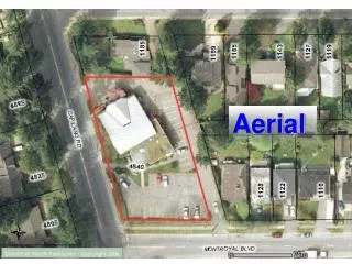
Bloodhound: Map Example map: Mean projection error 0.865278 pixels, 0.6 mile coverage, 5cm resolution SDSU CESAR UAV Image Management
Bloodhound: Map Example map: Mean projection error 0.865278 pixels, 0.6 mile coverage, 5cm resolution SDSU CESAR UAV Image Management
FAA & UAVs in National Airspace • FAA Certificate of Authorization (COA) • Issued for 1 year, can ‘renew’ certificate once • Currently available to Government agencies only • State, local, and Federal agencies • State Universities • Law enforcement, first responders • Application assistance available SDSU CESAR UAV Image Management
TerraPan Labs: Moving Forward • Managing multi-temporal archives of imagery • Post-earthquake change analysis project • Monterrey Naval Post-graduate School • SDSU • TerraPan Labs • Interactive data viewer • On-the-fly change analysis • Visual management of enormous image databases SDSU CESAR UAV Image Management
ImageTank • Extending the web-based model of tiles and zoom levels • Layers of data with movable ordering • Handles temporal or overlapping imagery • Breaking free of the single mosaic • On-the-fly analysis and visualization of results SDSU CESAR UAV Image Management
ImageTank • Subscription-based cloud service for hosting and processing of imagery • Social (public) or private sharing of views into your database • Low resource footprint for municipalities and organizations SDSU CESAR UAV Image Management
ImageTank: Comments? • Imagery management solutions • Sharing of imagery publicly or privately • Collaborative analysis • IT Resources (storage, security) SDSU CESAR UAV Image Management
Questions? More info: Lippitt@TerraPanLabs.com Fraley@TerraPanLabs.com www.TerraPanLabs.com Facebook.com/TerraPanLabs Twitter.com/TerraPanLabs