Download
1 / 28
350 likes | 554 Vues
Jochen Kerkmann Satellite Meteorologist, Training Officer jochen.kerkmann@eumetsat.int www.eumetsat.int Contributors: D. Rosenfeld (HUJ), I. Lensky (HUJ) J. Prieto (EUM), D. Lindsey (CIRA) K. Kollath & M. Putsay (HMS) P. Watts & M. Koenig (EUM).

E N D
Jochen Kerkmann Satellite Meteorologist, Training Officer jochen.kerkmann@eumetsat.int www.eumetsat.int Contributors: D. Rosenfeld (HUJ), I. Lensky (HUJ) J. Prieto (EUM), D. Lindsey (CIRA) K. Kollath & M. Putsay (HMS) P. Watts & M. Koenig (EUM) UNDERSTANDING CONVECTIVE CLOUDS THROUGH THE EYES OF (MSG)Cloud Particle Size
Observing Cloud Particle Size MFG: not possible ( only cloud thickness and cloud top temperature) • MSG: possible ( 2 window channels) • NIR1.6 and IR3.9r channels (day) • IR3.9 - IR10.8 BTD (day & night (warm clouds)) • IR8.7 – IR10.8
Reflection of Solar Radiation • Reflection at NIR1.6 and IR3.9 is sensitive to cloud phase and very sensitive to particle size • Higher reflection from water droplets than from ice particles • During daytime, clouds with small water droplets (St, Sc) are much darker than ice clouds(inverted image) Figure by COMET
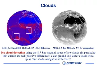
Difference IR3.9 - IR10.8: Cloud Particle Size Maputo Large Ice Particles (+26/+35 K) Small Ice Particles (+65/+73 K) MSG-1, 6 November 2004, 12:00 UTC, Difference IR3.9 - IR10.8 Range: -5 K (black) to +70 K (white), Gamma = 0.5
Observed IR3.9 - IR10.8 BTD for Opaque Ice Clouds Cloud Top Temperature -70°C -60°C -50°C IR3.9 Refl. 10 8 6 4 2 0 78 68 56 72 62 50 65 55 43 58 47 35 47 37 25 0 0 0 IR3.9 - IR10.8 brightness temperature difference depends on both:cloud particle size and cloud top temperature (and sun/satellite viewing angles)
Where do small ice particles form ? • in Cb clouds with strong updrafts • in Cb clouds with cold (high) cloud base (short time from cloud base to spontaneous freezing level) • in mountain wave and Pileus clouds • in highly “polluted” clouds • generally: in ice clouds that form rapidly
Updraft Effect “Updraft” Effect This idea follows from results from multiple papers by D. Rosenfeld, and Heymsfield et al. (2005)
„Cloud Depth“ Effect This idea follows from results from multiple papers by D. Rosenfeld, and Heymsfield et al. (2005)
Particle Size seen in Day Convective Storms RGB Maputo Thick Ice Cloud (large ice) Thick Ice Cloud (small ice) MSG-1, 6 November 2004, 12:00 UTC
RGB 05-06, 04-09, 03-01 ("Day Convective Storms") devised by: J. Kerkmann Recommended Range and Enhancement: Beam Channel Range Gamma Red WV6.2 - WV7.3 -35 … +5 K 1.0 Green IR3.9 - IR10.8 -5 … +60 K 0.5 Blue NIR1.6 - VIS0.6 -75 … +25 % 1.0
Colour Interpretation Deep precipitating cloud (precip. not necessarily reaching the ground) - high-level cloud - large ice particles Deep precipitating cloud (Cb cloud with strong updrafts and severe weather)* - high-level cloud - small ice particles *or thick, high-level lee cloudiness with small ice particles Thin Cirrus cloud (large ice particles) Thin Cirrus cloud (small ice particles) Ocean Land
Comparison RGB Convection vs RGB Nat. Colours 1. Large ice (dissipating storm) 2. Small ice (strong updrafts, large hail) 2 1 RGB Convection RGB Nat. Colours MSG-1, 29 June 2006, 12:00 UTC
Small ice (high IR3.9r of 6-7%) • Long-living storm system • Convective outflow boundary • Overshooting tops • Gravity waves • Radial Ci 12:15 UTC(animation 2/7)
IR3.9-IR10.8 depends on both HRV +radar Convective Storms RGB: G=IR3.9-IR10.8 IR3.9refl IR10.8
IR3.9-IR10.8 depends on both HRV +radar Convective Storms RGB: G=IR3.9-IR10.8 IR3.9refl IR10.8
Comparison RGB 02,04r,09 vs RGB 05-06,04-09,03-01 RGB 02, 04r ,09 RGB 05-06, 04-09, 03-01 better identification of young, severe storms MSG-1, 13 June 2003, 12:00 UTC
Small Ice Particles in Clouds with Cold Base Cb Cloud (small ice, IR3.9r=16%) MSG-2, 3 April 2008, 12:30 UTC
Small Ice Particles in “Polluted” Clouds Thick Ice Cloud (small ice) dust outbreak MSG-1, 22 February 2007, 12:00 UTC
Small Ice Particles in High-level Lee Cloudiness Very cold clouds(lee cloudiness) withsmall ice particles MSG-1, 19 March 2007, 08:00 UTC RGB WV6.2-WV7.3, IR3.9-IR10.8, NIR1.6-VIS0.6 (RGB Convection)
Small Ice Particles in isolated High-level Wave Cloud Mountain wave cloud withsmall ice particles MSG-2, 11 April 2008, 11:00 UTC Metop-A, AVHRR, 8:49 UTC
Small Ice Particles in Pileus Clouds André Simon, Mária Putsay, ÁkosHorváth: Is the appearance of this yellow spot connected to the Pileus? 15:27 UTC Pileus cloud Balatonalmádi
Summary (for thick, cold ice clouds, day) Small Large NIR1.6 high Refl. (40-50%) low Refl. (30%) IR3.9r high Refl. (5-10%) low Refl. (1-2%) IR3.9 - IR10.8 large pos. (40-75 K) pos. (20-30 K) Day Microphys. RGB Convection RGB